Estimated Value: $387,000 - $574,000
--
Bed
--
Bath
--
Sq Ft
4,530
Sq Ft Lot
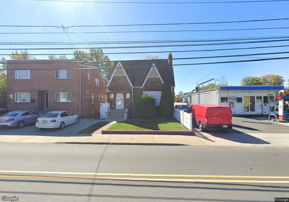
About This Home
This home is located at 2672 Morris Ave, Union, NJ 07083 and is currently estimated at $511,495. 2672 Morris Ave is a home located in Union County with nearby schools including Battle Hill Elementary School, Burnet Middle School, and Union High School.
Ownership History
Date
Name
Owned For
Owner Type
Purchase Details
Closed on
Aug 23, 2006
Sold by
Padovano Michael
Bought by
Freeland Vernon
Current Estimated Value
Home Financials for this Owner
Home Financials are based on the most recent Mortgage that was taken out on this home.
Original Mortgage
$342,000
Interest Rate
8.59%
Mortgage Type
Adjustable Rate Mortgage/ARM
Purchase Details
Closed on
Aug 30, 1996
Sold by
Padovano Mary
Bought by
Padovano Michael and Padovano Jerry
Purchase Details
Closed on
Aug 20, 1996
Sold by
Padovano Mary and Padovano Michael
Bought by
Padovano Mary
Create a Home Valuation Report for This Property
The Home Valuation Report is an in-depth analysis detailing your home's value as well as a comparison with similar homes in the area
Home Values in the Area
Average Home Value in this Area
Purchase History
| Date | Buyer | Sale Price | Title Company |
|---|---|---|---|
| Freeland Vernon | $360,000 | -- | |
| Padovano Michael | -- | -- | |
| Padovano Mary | -- | -- |
Source: Public Records
Mortgage History
| Date | Status | Borrower | Loan Amount |
|---|---|---|---|
| Previous Owner | Freeland Vernon | $342,000 |
Source: Public Records
Tax History Compared to Growth
Tax History
| Year | Tax Paid | Tax Assessment Tax Assessment Total Assessment is a certain percentage of the fair market value that is determined by local assessors to be the total taxable value of land and additions on the property. | Land | Improvement |
|---|---|---|---|---|
| 2025 | $10,393 | $46,500 | $18,000 | $28,500 |
| 2024 | $10,076 | $46,500 | $18,000 | $28,500 |
| 2023 | $10,076 | $46,500 | $18,000 | $28,500 |
| 2022 | $9,726 | $46,500 | $18,000 | $28,500 |
| 2021 | $9,490 | $46,500 | $18,000 | $28,500 |
| 2020 | $9,301 | $46,500 | $18,000 | $28,500 |
| 2019 | $9,176 | $46,500 | $18,000 | $28,500 |
| 2018 | $9,020 | $46,500 | $18,000 | $28,500 |
| 2017 | $8,886 | $46,500 | $18,000 | $28,500 |
| 2016 | $8,669 | $46,500 | $18,000 | $28,500 |
| 2015 | $8,526 | $46,500 | $18,000 | $28,500 |
| 2014 | $8,335 | $46,500 | $18,000 | $28,500 |
Source: Public Records
Map
Nearby Homes
- 2636 Frederick Terrace
- 980 Moessner Ave
- 960 Moessner Ave
- 2641 Burns Place
- 2785 Larchmont Rd
- 2615 Burns Place
- 1042 Battle Hill Terrace
- 1071 Battle Hill Terrace
- 2 Bashford-B Unit B
- 8 Bashford Ave Unit 8
- 2670 Bancroft Ave
- 2505 Girard Place
- 2620 Eleanor Terrace
- 920 Peach Tree Rd
- 888 Peach Tree Rd
- 798 Pinewood Rd
- 1080 Gruber Ave
- 2535 Standish Ave
- 1114 Elker Rd
- 30 Washington Ave
- 2668 Morris Ave
- 987 Liberty Ave
- 985 Liberty Ave
- 983 Liberty Ave
- 2639 Frederick Terrace
- 986 Liberty Ave
- 984 Liberty Ave
- 2643 Frederick Terrace
- 2660 Morris Ave
- 2631 Frederick Terrace
- 2701 Morris Ave
- 973 Liberty Ave
- 982 Liberty Ave
- 2627 Frederick Terrace
- 989 Moessner Ave
- 969 Liberty Ave
- 2705 Morris Ave
- 985 Moessner Ave
- 2644 Frederick Terrace
- 2623 Frederick Terrace