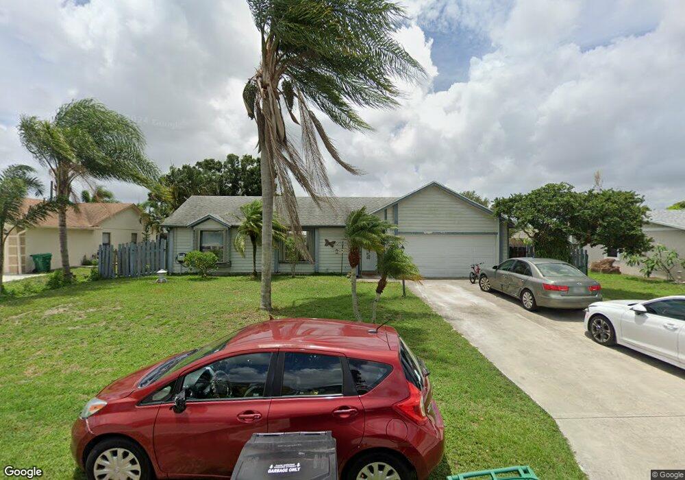
268 SW Aubudon Ave Port Saint Lucie, FL 34984
Canal Pointe NeighborhoodEstimated Value: $345,000 - $370,000
3
Beds
2
Baths
1,495
Sq Ft
$238/Sq Ft
Est. Value
About This Home
This home is located at 268 SW Aubudon Ave, Port Saint Lucie, FL 34984 and is currently estimated at $355,346, approximately $237 per square foot. 268 SW Aubudon Ave is a home located in St. Lucie County with nearby schools including Floresta Elementary School, Morningside Elementary School, and Northport K-8 School.
Ownership History
Date
Name
Owned For
Owner Type
Purchase Details
Closed on
Nov 23, 2011
Sold by
Luciano Mark
Bought by
Luciano Margaret
Current Estimated Value
Purchase Details
Closed on
Jun 19, 1996
Sold by
Gullusci Frank N and Gullusci Patricia A
Bought by
Luciano Mark and Luciano Margaret F
Home Financials for this Owner
Home Financials are based on the most recent Mortgage that was taken out on this home.
Original Mortgage
$56,400
Outstanding Balance
$3,620
Interest Rate
8.05%
Estimated Equity
$351,726
Create a Home Valuation Report for This Property
The Home Valuation Report is an in-depth analysis detailing your home's value as well as a comparison with similar homes in the area
Home Values in the Area
Average Home Value in this Area
Purchase History
| Date | Buyer | Sale Price | Title Company |
|---|---|---|---|
| Luciano Margaret | -- | None Available | |
| Luciano Mark | $78,000 | -- |
Source: Public Records
Mortgage History
| Date | Status | Borrower | Loan Amount |
|---|---|---|---|
| Open | Luciano Mark | $56,400 |
Source: Public Records
Tax History Compared to Growth
Tax History
| Year | Tax Paid | Tax Assessment Tax Assessment Total Assessment is a certain percentage of the fair market value that is determined by local assessors to be the total taxable value of land and additions on the property. | Land | Improvement |
|---|---|---|---|---|
| 2024 | $1,371 | $253,200 | $130,000 | $123,200 |
| 2023 | $1,371 | $76,395 | $0 | $0 |
| 2022 | $1,279 | $74,170 | $0 | $0 |
| 2021 | $1,202 | $72,010 | $0 | $0 |
| 2020 | $1,209 | $71,016 | $0 | $0 |
| 2019 | $1,214 | $69,420 | $0 | $0 |
| 2018 | $1,163 | $68,126 | $0 | $0 |
| 2017 | $1,209 | $107,700 | $28,000 | $79,700 |
| 2016 | $1,210 | $110,500 | $21,600 | $88,900 |
| 2015 | $1,223 | $85,800 | $14,000 | $71,800 |
| 2014 | $1,184 | $70,644 | $0 | $0 |
Source: Public Records
Map
Nearby Homes
- 2410 SW Bayshore Blvd
- 279 SW Statler Ave
- 2385 SW Mountwell St
- 171 SW Glenwood Dr
- 2509 SW Cooper Ln
- 2445 SW Falcon Cir
- 2458 SW Hinchman St
- 2433 SW Hinchman St
- 131 SW Essex Dr
- 2624 SW Harem Cir
- 272 SW Oakridge Dr
- 2613 SW Harem Cir
- 213 SW Chapman Ave
- 158 SW Port St Lucie Blvd
- 2473 SW Warwick St
- 2590 SW Hinchman St
- 201 SW Chapman Ave
- 154 SW Port St Lucie Blvd
- 13865 SE Blackwood Dr
- 142 SW Port Saint Lucie Blvd
- 274 SW Aubudon Ave
- 262 SW Aubudon Ave
- 256 SW Aubudon Ave
- 287 SW Airview Ave
- 295 SW Airview Ave
- 281 SW Airview Ave
- 278 SW Aubudon Ave
- 261 SW Aubudon Ave
- 267 SW Aubudon Ave
- 271 SW Aubudon Ave
- 273 SW Airview Ave
- 273 SW Airview Ave
- 2419 SW Bayshore Blvd
- 255 SW Aubudon Ave
- 250 SW Aubudon Ave
- 282 SW Aubudon Ave
- 265 SW Airview Ave
- 249 SW Aubudon Ave
- 249 SW Audubon Ave
- 268 SW Moselle Ave