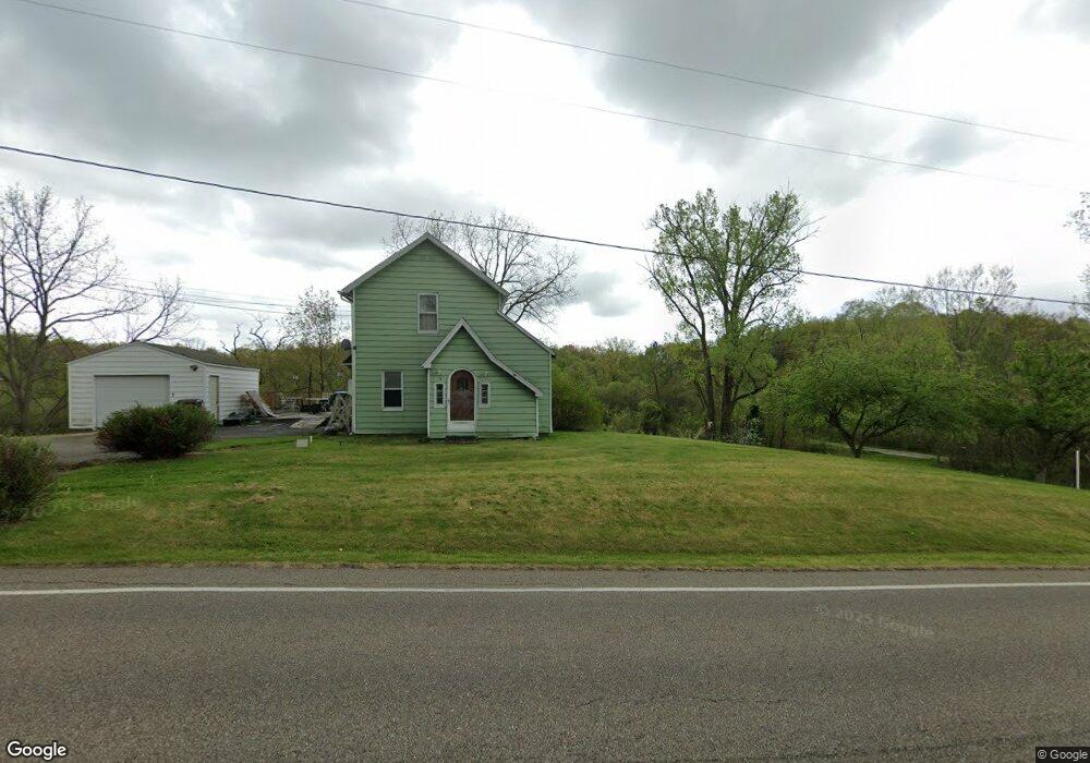
2680 Killian Rd Uniontown, OH 44685
Estimated Value: $185,000 - $217,000
2
Beds
2
Baths
1,404
Sq Ft
$142/Sq Ft
Est. Value
About This Home
This home is located at 2680 Killian Rd, Uniontown, OH 44685 and is currently estimated at $199,729, approximately $142 per square foot. 2680 Killian Rd is a home located in Summit County with nearby schools including Springfield High School, Chapel Hill Christian School-Green Campus, and Mayfair Christian School.
Ownership History
Date
Name
Owned For
Owner Type
Purchase Details
Closed on
Jan 18, 2002
Sold by
Morrison Jack
Bought by
Morrison Catherine
Current Estimated Value
Purchase Details
Closed on
Nov 3, 1998
Sold by
Baker Mondell W
Bought by
Morrison Jack and Morrison Catherine
Home Financials for this Owner
Home Financials are based on the most recent Mortgage that was taken out on this home.
Original Mortgage
$56,500
Interest Rate
6.72%
Mortgage Type
Balloon
Create a Home Valuation Report for This Property
The Home Valuation Report is an in-depth analysis detailing your home's value as well as a comparison with similar homes in the area
Home Values in the Area
Average Home Value in this Area
Purchase History
| Date | Buyer | Sale Price | Title Company |
|---|---|---|---|
| Morrison Catherine | -- | -- | |
| Morrison Jack | $95,000 | Midland Commerce Group |
Source: Public Records
Mortgage History
| Date | Status | Borrower | Loan Amount |
|---|---|---|---|
| Closed | Morrison Jack | $56,500 |
Source: Public Records
Tax History Compared to Growth
Tax History
| Year | Tax Paid | Tax Assessment Tax Assessment Total Assessment is a certain percentage of the fair market value that is determined by local assessors to be the total taxable value of land and additions on the property. | Land | Improvement |
|---|---|---|---|---|
| 2025 | $2,902 | $52,577 | $14,203 | $38,374 |
| 2024 | $2,902 | $52,577 | $14,203 | $38,374 |
| 2023 | $2,902 | $52,577 | $14,203 | $38,374 |
| 2022 | $2,841 | $44,566 | $10,602 | $33,964 |
| 2021 | $2,774 | $44,566 | $10,602 | $33,964 |
| 2020 | $2,734 | $44,560 | $10,600 | $33,960 |
| 2019 | $2,572 | $38,850 | $10,600 | $28,250 |
| 2018 | $2,469 | $38,850 | $10,600 | $28,250 |
| 2017 | $2,270 | $38,850 | $10,600 | $28,250 |
| 2016 | $2,291 | $34,290 | $10,600 | $23,690 |
| 2015 | $2,270 | $34,290 | $10,600 | $23,690 |
| 2014 | $2,242 | $34,290 | $10,600 | $23,690 |
| 2013 | $2,294 | $34,940 | $10,600 | $24,340 |
Source: Public Records
Map
Nearby Homes
- 2575 Myersville Rd
- 2424 Lyndon Dr
- 2512 Twin Lakes Dr
- 1830 B St
- 3540 Bushwillow Dr
- 2941 Sweitzer Rd
- 2771 Superior Dr
- 2944 Sunset Dr
- 13792 Amodio Ave NW
- 1821 Myersville Rd
- 2840 Canton Rd
- 2737 Gowanda Dr
- 1605 Pawnee Blvd
- 3355 Overlook Dr
- 3979 Northdale St NW
- 13170 Crestview Cir NW
- 2667 Spade Rd
- 3771 Edison St NW
- 2690 Mayfair Rd
- 0 Killian Rd Unit 5145777
- 2207 Waterbury Dr
- 2190 Waterbury Dr
- 2651 Killian Rd
- 2191 Waterbury Dr
- 2715 Killian Rd
- 2650 Killian Rd
- 2641 Killian Rd
- 2644 Canaan Dr
- 2175 Waterbury Dr
- 2731 Killian Rd
- 2620 Killian Rd
- 2634 Canaan Dr
- 2631 Killian Rd
- 2624 Canaan Dr
- 2743 Killian Rd
- 2159 Waterbury Dr
- 2621 Killian Rd
- 2218 Manor Rd
- 2616 Canaan Dr
- 2208 Manor Rd