
Seller's Agent in 2025
Kevin Majeski
Carpenter, REALTORS®
(317) 537-7115
98 in this area
157 Total Sales
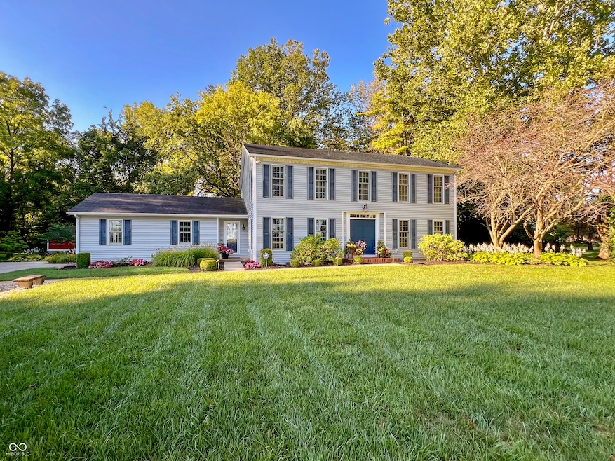
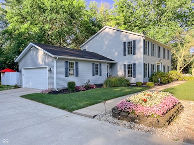
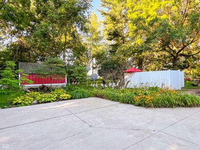

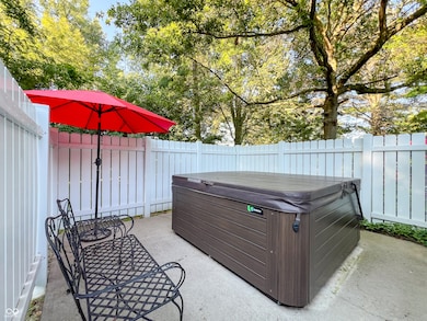
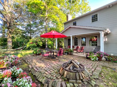
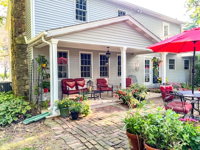
Gorgeous! This beautifully renovated 4-Bed, 3.5 Bath home sits on 1.8 acres surrounded by mature trees, offering the perfect blend of modern updates and a peaceful country setting. The spacious property offers privacy, tranquility, and plenty of room for outdoor activities-perfect for making lasting memories with loved ones. The Foyer showcases a stunning staircase complemented by an elegant wall treatment. The home's sprawling layout provides exceptional versatility, seamlessly connecting rooms to create an effortless flow, perfect for entertaining with ease. The Living Room is bright and spacious enough for large gatherings. The Dining Room features a stone fireplace and ample space, making it perfect for family gatherings or dinner parties. The heart of the home is the impressive Kitchen offering stainless-steel appliances, granite countertops, a built-in buffet hutch, and a center island with a stunning handcrafted wooden countertop-a perfect setting for morning coffee or meals on the go. The adjacent Family Room is just the right size for cozy movie nights or watching the big game. The Main Level also features a Half Bath and Laundry Room. Upstairs are 4 bedrooms, each with plenty of closet space & neutral colors. The primary suite offers an updated en-suite bathroom with a step-in shower. The remaining 3 bedrooms are generously sized, each offering a unique highlight. One features a private balcony! All share the full bath situated in the hallway. But that's not all... the finished basement expands this home's living space with a spacious bonus room and guest quarters, complete with a full bathroom and a fully functional mini-kitchen! The home's exterior is just as impressive, featuring a serene backyard with a private hot tub, covered patio, vibrant flower beds, fire pit, & mature trees for shade. There's also a mini-storage barn & a two-car garage for plenty of storage. With its ideal location, gorgeous updates, and charming details, this home has it all.
Last Agent to Sell the Property
Carpenter, REALTORS® License #RB15000010 Listed on: 07/04/2025
| Date | Type | Sale Price | Title Company |
|---|---|---|---|
| Quit Claim Deed | -- | Absolute Title Inc | |
| Warranty Deed | -- | Absolute Title Inc | |
| Interfamily Deed Transfer | -- | None Available |
| Date | Status | Loan Amount | Loan Type |
|---|---|---|---|
| Open | $340,000 | New Conventional |
| Date | Event | Price | List to Sale | Price per Sq Ft |
|---|---|---|---|---|
| 07/30/2025 07/30/25 | Sold | $425,000 | 0.0% | $116 / Sq Ft |
| 07/07/2025 07/07/25 | Pending | -- | -- | -- |
| 07/04/2025 07/04/25 | For Sale | $425,000 | -- | $116 / Sq Ft |
| Year | Tax Paid | Tax Assessment Tax Assessment Total Assessment is a certain percentage of the fair market value that is determined by local assessors to be the total taxable value of land and additions on the property. | Land | Improvement |
|---|---|---|---|---|
| 2025 | $1,999 | $179,900 | $22,400 | $157,500 |
| 2024 | $1,999 | $179,900 | $22,400 | $157,500 |
| 2023 | $1,836 | $164,100 | $21,300 | $142,800 |
| 2022 | $1,779 | $160,400 | $20,300 | $140,100 |
| 2021 | $1,613 | $146,900 | $20,100 | $126,800 |
| 2020 | $1,618 | $146,000 | $18,700 | $127,300 |
| 2019 | $911 | $146,100 | $18,700 | $127,400 |
| 2018 | $1,365 | $136,900 | $18,700 | $118,200 |
| 2017 | $1,137 | $124,800 | $18,200 | $106,600 |
| 2016 | $973 | $120,800 | $17,800 | $103,000 |
| 2014 | $907 | $113,900 | $16,700 | $97,200 |
| 2013 | $907 | $118,800 | $16,700 | $102,100 |
Seller's Agent in 2025
Kevin Majeski
Carpenter, REALTORS®
(317) 537-7115
98 in this area
157 Total Sales
B
Buyer's Agent in 2025
Brittney White
RE/MAX Real Estate Solutions
(765) 623-9892
25 in this area
44 Total Sales
Source: MIBOR Broker Listing Cooperative®
MLS Number: 22047881
APN: 48-07-21-400-007.000-029
Disclaimer: Certain information contained herein is derived from information provided by parties other than Homes.com. All information provided is deemed reliable, but is not guaranteed to be accurate and should be independently verified.
![]() Based on information submitted to the MLS GRID. All data is obtained from various sources and may not have been verified by broker or MLS GRID. Supplied Open House Information is subject to change without notice. All information should be independently reviewed and verified for accuracy. Properties may or may not be listed by the office/agent presenting the information. Some IDX listings have been excluded from this website.
Based on information submitted to the MLS GRID. All data is obtained from various sources and may not have been verified by broker or MLS GRID. Supplied Open House Information is subject to change without notice. All information should be independently reviewed and verified for accuracy. Properties may or may not be listed by the office/agent presenting the information. Some IDX listings have been excluded from this website.