Estimated Value: $575,000 - $740,711
4
Beds
3
Baths
--
Sq Ft
5,401
Sq Ft Lot
About This Home
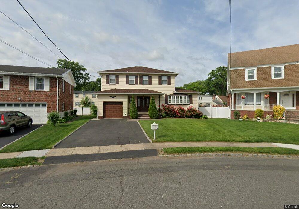
This home is located at 2683 Hawthorne Ave, Union, NJ 07083 and is currently estimated at $648,428. 2683 Hawthorne Ave is a home located in Union County with nearby schools including Hannah Caldwell Elementary School, Burnet Middle School, and Union High School.
Ownership History
Date
Name
Owned For
Owner Type
Purchase Details
Closed on
Feb 28, 2011
Sold by
Degrazio Michele
Bought by
Estivene Sabine
Current Estimated Value
Home Financials for this Owner
Home Financials are based on the most recent Mortgage that was taken out on this home.
Original Mortgage
$329,431
Outstanding Balance
$231,194
Interest Rate
5.25%
Mortgage Type
FHA
Estimated Equity
$417,234
Purchase Details
Closed on
Nov 30, 1995
Sold by
Loeffler Charles A and Loeffler Florence
Bought by
Degrazio Joseph
Create a Home Valuation Report for This Property
The Home Valuation Report is an in-depth analysis detailing your home's value as well as a comparison with similar homes in the area
Home Values in the Area
Average Home Value in this Area
Purchase History
| Date | Buyer | Sale Price | Title Company |
|---|---|---|---|
| Estivene Sabine | $338,000 | Title Consulting Services Ll | |
| Degrazio Joseph | $185,000 | -- |
Source: Public Records
Mortgage History
| Date | Status | Borrower | Loan Amount |
|---|---|---|---|
| Open | Estivene Sabine | $329,431 |
Source: Public Records
Tax History Compared to Growth
Tax History
| Year | Tax Paid | Tax Assessment Tax Assessment Total Assessment is a certain percentage of the fair market value that is determined by local assessors to be the total taxable value of land and additions on the property. | Land | Improvement |
|---|---|---|---|---|
| 2025 | $12,360 | $55,300 | $21,100 | $34,200 |
| 2024 | $11,983 | $55,300 | $21,100 | $34,200 |
| 2023 | $11,983 | $55,300 | $21,100 | $34,200 |
| 2022 | $11,567 | $55,300 | $21,100 | $34,200 |
| 2021 | $11,286 | $55,300 | $21,100 | $34,200 |
| 2020 | $11,061 | $55,300 | $21,100 | $34,200 |
| 2019 | $10,912 | $55,300 | $21,100 | $34,200 |
| 2018 | $10,727 | $55,300 | $21,100 | $34,200 |
| 2017 | $10,568 | $55,300 | $21,100 | $34,200 |
| 2016 | $10,310 | $55,300 | $21,100 | $34,200 |
| 2015 | $10,139 | $55,300 | $21,100 | $34,200 |
| 2014 | $9,912 | $55,300 | $21,100 | $34,200 |
Source: Public Records
Map
Nearby Homes
- 2641 Burns Place
- 2620 Eleanor Terrace
- 2615 Burns Place
- 1071 Battle Hill Terrace
- 2 Bashford-B Unit B
- 2535 Standish Ave
- 1042 Battle Hill Terrace
- 8 Bashford Ave Unit 8
- 2785 Larchmont Rd
- 1239 Rony Rd
- 1214 Carlton Terrace
- 2510 Crane Place
- 980 Moessner Ave
- 2636 Frederick Terrace
- 2505 Girard Place
- 1114 Elker Rd
- 960 Moessner Ave
- 1163 Burnet Ave
- 1270 Carlton Terrace
- 1080 Gruber Ave
- 2687 Hawthorne Ave
- 2679 Hawthorne Ave
- 2647 Burns Place
- 2643 Burns Place
- 2651 Burns Place
- 2691 Hawthorne Ave
- 2675 Hawthorne Ave
- 2668 Hawthorne Ave
- 2655 Burns Place
- 2659 Burns Place
- 2671 Hawthorne Ave
- 2664 Hawthorne Ave
- 1103 Liberty Ave
- 2633 Leslie St
- 1107 Liberty Ave
- 2667 Hawthorne Ave
- 1095 Liberty Ave
- 2660 Hawthorne Ave
- 2630 Leslie St
- 1113 Liberty Ave