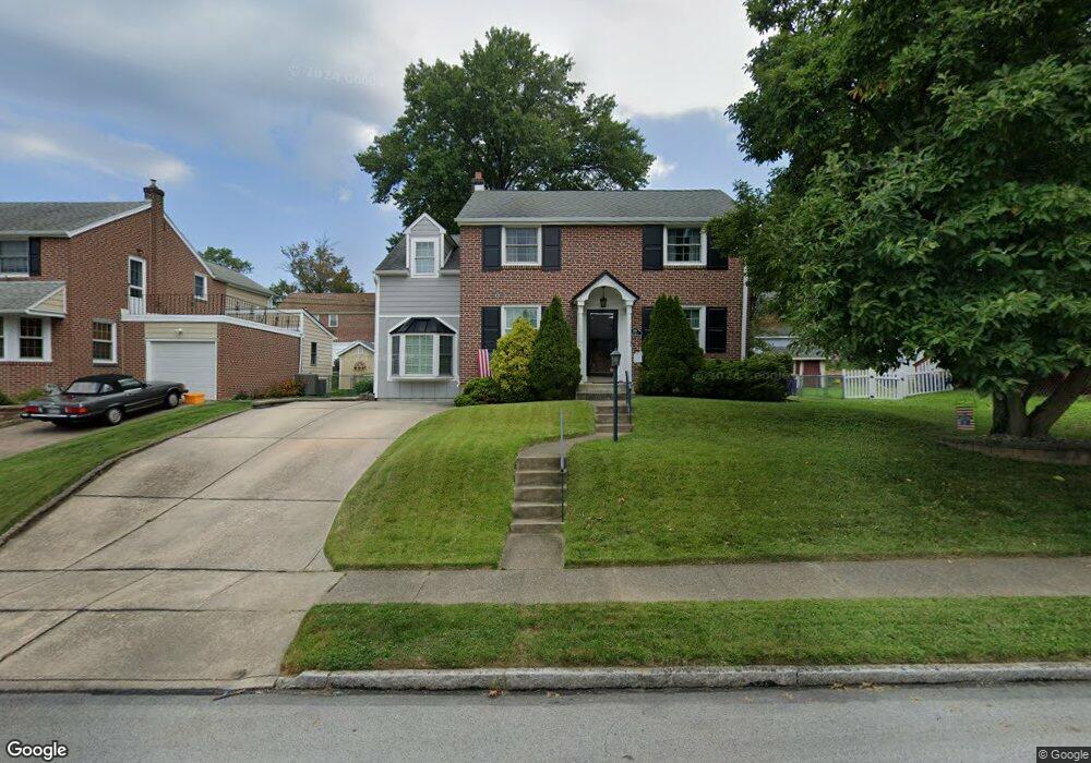
269 Sunnybrook Rd Springfield, PA 19064
Estimated Value: $550,000 - $645,000
4
Beds
3
Baths
2,807
Sq Ft
$212/Sq Ft
Est. Value
About This Home
This home is located at 269 Sunnybrook Rd, Springfield, PA 19064 and is currently estimated at $596,362, approximately $212 per square foot. 269 Sunnybrook Rd is a home located in Delaware County with nearby schools including Springfield High School, St Francis Of Assisi School, and Holy Cross School.
Ownership History
Date
Name
Owned For
Owner Type
Purchase Details
Closed on
Sep 28, 1998
Sold by
Septor Nelson C
Bought by
Smith William J and Smith Jean A
Current Estimated Value
Home Financials for this Owner
Home Financials are based on the most recent Mortgage that was taken out on this home.
Original Mortgage
$152,000
Outstanding Balance
$33,250
Interest Rate
6.89%
Estimated Equity
$563,112
Create a Home Valuation Report for This Property
The Home Valuation Report is an in-depth analysis detailing your home's value as well as a comparison with similar homes in the area
Home Values in the Area
Average Home Value in this Area
Purchase History
| Date | Buyer | Sale Price | Title Company |
|---|---|---|---|
| Smith William J | $160,000 | T A Title Insurance Company |
Source: Public Records
Mortgage History
| Date | Status | Borrower | Loan Amount |
|---|---|---|---|
| Open | Smith William J | $152,000 |
Source: Public Records
Tax History
| Year | Tax Paid | Tax Assessment Tax Assessment Total Assessment is a certain percentage of the fair market value that is determined by local assessors to be the total taxable value of land and additions on the property. | Land | Improvement |
|---|---|---|---|---|
| 2025 | $9,849 | $350,400 | $95,500 | $254,900 |
| 2024 | $9,849 | $350,400 | $95,500 | $254,900 |
| 2023 | $9,483 | $350,400 | $95,500 | $254,900 |
| 2022 | $9,278 | $350,400 | $95,500 | $254,900 |
| 2021 | $14,369 | $350,400 | $95,500 | $254,900 |
| 2020 | $7,852 | $173,290 | $45,910 | $127,380 |
| 2019 | $7,668 | $173,290 | $45,910 | $127,380 |
| 2018 | $7,558 | $173,290 | $0 | $0 |
| 2017 | $7,383 | $173,290 | $0 | $0 |
| 2016 | $951 | $173,290 | $0 | $0 |
| 2015 | $970 | $173,290 | $0 | $0 |
| 2014 | $970 | $173,290 | $0 | $0 |
Source: Public Records
Map
Nearby Homes
- 173 Rambling Way
- 226 Lynbrooke Rd
- 29 School Ln
- 120 W Springfield Rd
- 514 Springview Ln
- 332 Franklin Ave
- 472 Larchwood Rd
- 227 E Leamy Ave
- 838 West Ave
- 220 N Rolling Rd
- 624 E Springfield Rd
- 207 N Bishop Ave
- 233 N Bishop Ave
- 364 S Rolling Rd
- 114 Providence Rd
- 978 Westfield Rd
- 401 N Sycamore Ave
- 238 Westpark Ln
- 412 N Rolling Rd
- 343 Westpark Ln
- 263 Sunnybrook Rd
- 275 Sunnybrook Rd
- 262 Ridgewood Rd
- 268 Ridgewood Rd
- 270 Sunnybrook Rd
- 257 Sunnybrook Rd
- 276 Sunnybrook Rd
- 264 Sunnybrook Rd
- 250 Ridgewood Rd
- 301 Sunnybrook Rd
- 258 Sunnybrook Rd
- 300 Ridgewood Rd
- 251 Sunnybrook Rd
- 300 Sunnybrook Rd
- 291 Avon Rd
- 244 Ridgewood Rd
- 295 Avon Rd
- 285 Avon Rd
- 261 Ridgewood Rd
- 307 Sunnybrook Rd
Your Personal Tour Guide
Ask me questions while you tour the home.