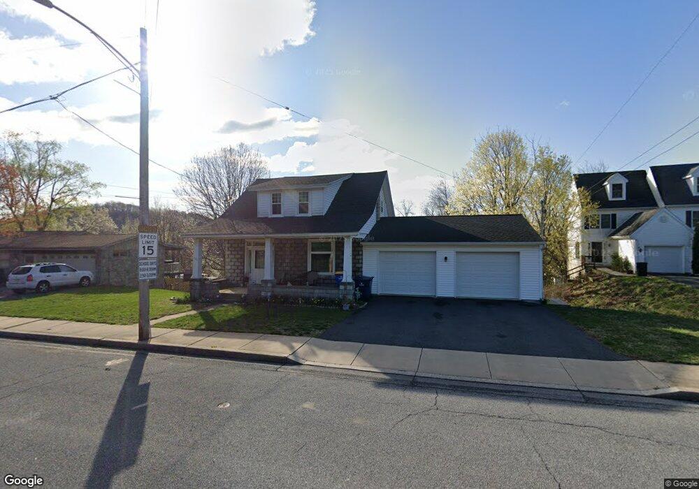
269 W Main St Adamstown, PA 19501
Estimated Value: $278,000 - $298,048
3
Beds
1
Bath
1,329
Sq Ft
$218/Sq Ft
Est. Value
About This Home
This home is located at 269 W Main St, Adamstown, PA 19501 and is currently estimated at $289,262, approximately $217 per square foot. 269 W Main St is a home located in Lancaster County with nearby schools including Cocalico Senior High School, Gehmans Mennonite School, and Trostle Hill School.
Ownership History
Date
Name
Owned For
Owner Type
Purchase Details
Closed on
May 1, 2003
Sold by
Weinhold Randy T
Bought by
Weinhold Randy T and Weinhold Susan M
Current Estimated Value
Home Financials for this Owner
Home Financials are based on the most recent Mortgage that was taken out on this home.
Original Mortgage
$74,500
Interest Rate
5.93%
Mortgage Type
Purchase Money Mortgage
Purchase Details
Closed on
Dec 31, 1996
Bought by
Weinhold Randy T
Create a Home Valuation Report for This Property
The Home Valuation Report is an in-depth analysis detailing your home's value as well as a comparison with similar homes in the area
Home Values in the Area
Average Home Value in this Area
Purchase History
| Date | Buyer | Sale Price | Title Company |
|---|---|---|---|
| Weinhold Randy T | -- | -- | |
| Weinhold Randy T | $87,900 | -- |
Source: Public Records
Mortgage History
| Date | Status | Borrower | Loan Amount |
|---|---|---|---|
| Closed | Weinhold Randy T | $74,500 |
Source: Public Records
Tax History Compared to Growth
Tax History
| Year | Tax Paid | Tax Assessment Tax Assessment Total Assessment is a certain percentage of the fair market value that is determined by local assessors to be the total taxable value of land and additions on the property. | Land | Improvement |
|---|---|---|---|---|
| 2025 | $4,024 | $160,000 | $52,300 | $107,700 |
| 2024 | $4,024 | $160,000 | $52,300 | $107,700 |
| 2023 | $3,931 | $160,000 | $52,300 | $107,700 |
| 2022 | $3,828 | $160,000 | $52,300 | $107,700 |
| 2021 | $3,828 | $160,000 | $52,300 | $107,700 |
| 2020 | $3,828 | $160,000 | $52,300 | $107,700 |
| 2019 | $3,783 | $160,000 | $52,300 | $107,700 |
| 2018 | $2,809 | $160,000 | $52,300 | $107,700 |
| 2017 | $3,614 | $124,400 | $31,100 | $93,300 |
| 2016 | $3,614 | $124,400 | $31,100 | $93,300 |
| 2015 | $776 | $100,500 | $24,100 | $76,400 |
| 2014 | $2,064 | $100,500 | $24,100 | $76,400 |
Source: Public Records
Map
Nearby Homes
- 102 Evergreen Rd
- 93 E Main St
- 303 W Swartzville Rd
- 82 Scenic Dr
- 17 W Kestrel Dr
- 2145 Old Lancaster Pike
- 17 Sanderling Dr
- 122 Witmer Rd
- 20 Hill Rd
- 770 Mohns Hill Rd
- 297 Orchard Rd
- 136 Martin Dr
- 27 Lausch Rd
- 310 Mail Route Rd
- 211 Kocher Rd
- 256 W Valley Rd
- 1175 W Swartzville Rd
- 346 Aplomado St
- Westbrooke Plan at Hawk Valley Estates
- Callahan Plan at Hawk Valley Estates
- 10 Adamstown Rd
- 10 Adamstown Rd Unit L5
- 257 W Main St
- 301 W Main St
- 303 W Main St
- 301 W Maint St
- 305 W Main St
- 253 W Main St
- 307 W Main St
- 309 W Main St
- 247 W Main St
- 313 W Main St
- 315 W Main St
- 243 W Main St
- 317 W Main St
- 64 Misty Meadows
- 64 Misty Meadow Dr
- 319 W Main St
- 319 W Main St
- 62 Misty Meadows