Estimated Value: $331,149 - $344,000
3
Beds
3
Baths
1,784
Sq Ft
$188/Sq Ft
Est. Value
About This Home
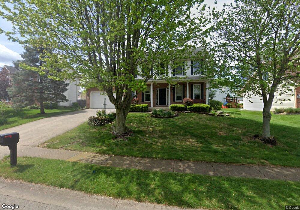
This home is located at 2695 Walnut Ridge Dr, Troy, OH 45373 and is currently estimated at $335,537, approximately $188 per square foot. 2695 Walnut Ridge Dr is a home located in Miami County with nearby schools including Concord Elementary School, Van Cleve Elementary School, and Troy Junior High School.
Ownership History
Date
Name
Owned For
Owner Type
Purchase Details
Closed on
Dec 4, 2019
Sold by
Sato Yuji and Sato Junko
Bought by
Looker Thomas L and Looker Pamela J
Current Estimated Value
Purchase Details
Closed on
Aug 15, 2003
Sold by
Schaefer Kenneth L and Schaefer Sandra E
Bought by
Sato Yuji and Sato Junko
Purchase Details
Closed on
Dec 2, 2002
Sold by
Altenburger Scott R and Altenburger Kay A
Bought by
Schaefer Kenneth L and Schaefer Sandra E
Purchase Details
Closed on
May 31, 1996
Sold by
Kegley Glennis
Bought by
Attenburger Scott R and Attenburger Kay A
Create a Home Valuation Report for This Property
The Home Valuation Report is an in-depth analysis detailing your home's value as well as a comparison with similar homes in the area
Home Values in the Area
Average Home Value in this Area
Purchase History
| Date | Buyer | Sale Price | Title Company |
|---|---|---|---|
| Looker Thomas L | $198,000 | None Available | |
| Sato Yuji | $168,500 | -- | |
| Schaefer Kenneth L | $180,000 | -- | |
| Attenburger Scott R | $159,000 | -- |
Source: Public Records
Tax History Compared to Growth
Tax History
| Year | Tax Paid | Tax Assessment Tax Assessment Total Assessment is a certain percentage of the fair market value that is determined by local assessors to be the total taxable value of land and additions on the property. | Land | Improvement |
|---|---|---|---|---|
| 2024 | $3,248 | $81,800 | $12,950 | $68,850 |
| 2023 | $3,248 | $81,800 | $12,950 | $68,850 |
| 2022 | $2,732 | $81,800 | $12,950 | $68,850 |
| 2021 | $2,425 | $68,150 | $10,780 | $57,370 |
| 2020 | $2,427 | $68,150 | $10,780 | $57,370 |
| 2019 | $2,387 | $68,150 | $10,780 | $57,370 |
| 2018 | $2,103 | $57,200 | $11,660 | $45,540 |
| 2017 | $2,123 | $57,200 | $11,660 | $45,540 |
| 2016 | $2,093 | $57,200 | $11,660 | $45,540 |
| 2015 | $2,015 | $52,960 | $10,780 | $42,180 |
| 2014 | $2,015 | $52,960 | $10,780 | $42,180 |
| 2013 | $2,028 | $52,960 | $10,780 | $42,180 |
Source: Public Records
Map
Nearby Homes
- 2765 Silver Maple Ct
- 445 Wisteria Dr
- 660 Wisteria Dr
- 203 Boone Dr
- 0 Lincolnshire Unit 939331
- 2215 Merrimont Dr
- 1701 Chevington Chase
- 2065 S Co Road 25a
- 1117 Honeydew Dr
- 1216 Wind Rock Ct
- 2015 Merrimont Dr
- 768 Stonehenge Dr
- Spruce Plan at Summit Landing
- Norway Plan at Summit Landing
- Chestnut Plan at Summit Landing
- Juniper Plan at Summit Landing
- Palmetto Plan at Summit Landing
- Ashton Plan at Summit Landing
- Empress Plan at Summit Landing
- Ironwood Plan at Summit Landing
- 2711 Walnut Ridge Dr
- 2675 Walnut Ridge Dr
- 2875 Red Oak Cir
- 2861 Red Oak Cir
- 2659 Walnut Ridge Dr
- 2690 Walnut Ridge Dr
- 2885 Red Oak Cir
- 2678 Walnut Ridge Dr
- 2851 Red Oak Cir
- 2706 Walnut Ridge Dr
- 2664 Walnut Ridge Dr
- 2643 Walnut Ridge Dr
- 2901 Red Oak Cir
- 2805 Silver Maple Ct
- 2765 Walnut Ridge Dr
- 2650 Walnut Ridge Dr
- 2633 Walnut Ridge Dr
- 2860 Red Oak Cir
- 2785 Walnut Ridge Dr
- 2882 Red Oak Cir