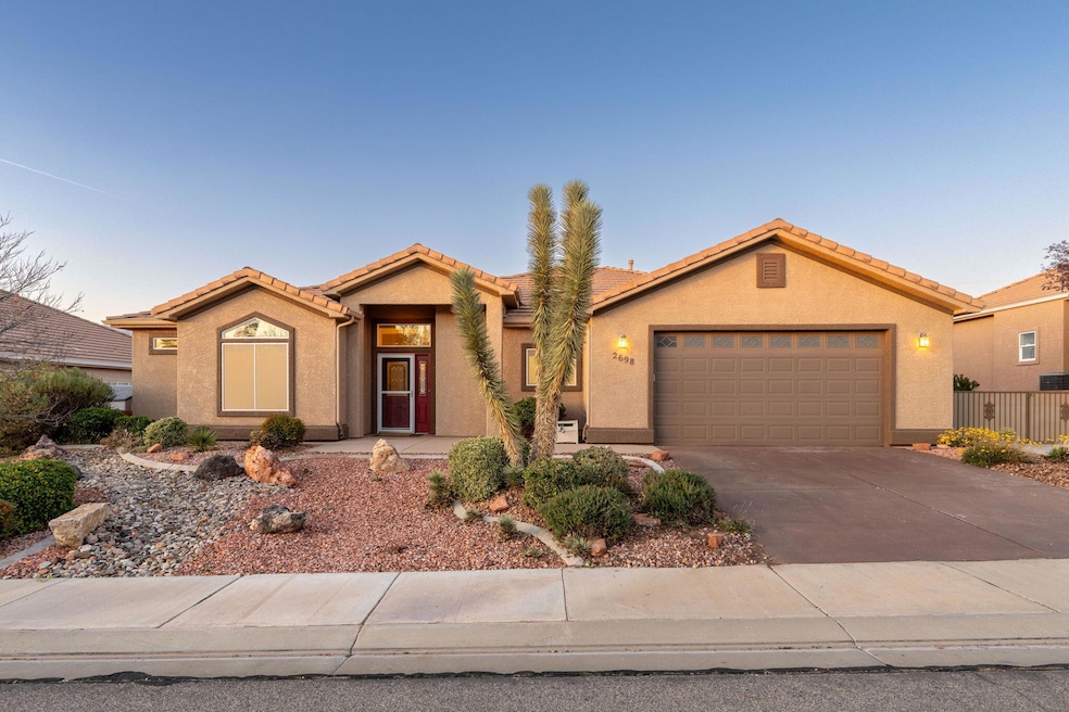
2698 W 510 N Hurricane, UT 84737
Estimated payment $2,770/month
Highlights
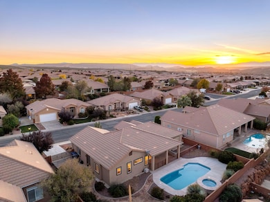
- Heated In Ground Pool
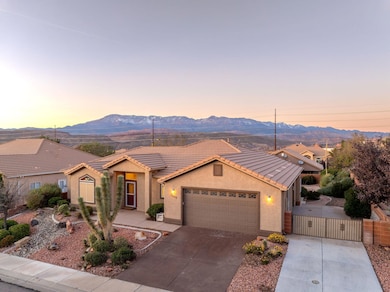
- Mountain View
- No HOA
- RV Access or Parking
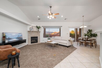
- Vaulted Ceiling
- Covered Patio or Porch
About This Home
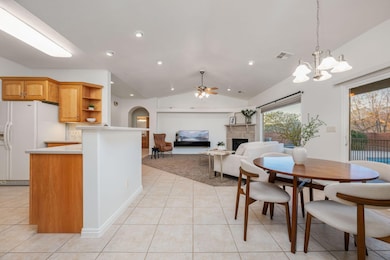
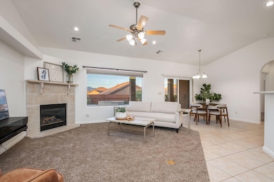
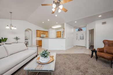
We know you've got your ultimate house-hunting wish list... and this one doesn't just check the boxes — it nails them. Affordable, move-in ready, a private pool & spa, RV parking, and Pine Valley views all come together in a home that makes life easy from day one! Inside, everything feels fresh thanks to brand-new paint throughout (ceilings, walls, trim, and doors) and new carpet in the living room and bedrooms. All the updates are already done — just unpack and enjoy. The backyard might be your favorite part: fully landscaped, completely low-maintenance (no lawn mower needed), and thoughtfully designed with color and texture year-round. A gated, covered patio adds an extra layer of safety for pets and little ones near the pool, while a separate flagstone patio surrounded by greenery creates the perfect spot for a fire pit or quiet evenings outside. And yes there's RV parking, giving you space for toys, trailers, and whatever adventure calls next. Even better, there's no HOA, so you get the freedom to actually use it. The three-bedroom, two-bath layout includes surprisingly roomy bathrooms, extra storage throughout, and a built-in Murphy bed for guests or flexible work-from-home space. Even the Washer and dryer are included, saving you time and money from the start. A home that gives you everything you were hoping for without compromise. (The buyer is responsible to verify all listing information to the buyer's own satisfaction.)
Listing Agent
KW Ascend Keller Williams Realty License #11334177-SA Listed on: 11/28/2025

Home Details
Home Type
- Single Family
Est. Annual Taxes
- $1,966
Year Built
- Built in 2006
Lot Details
- 8,276 Sq Ft Lot
- Landscaped
- Sprinkler System
Parking
- Attached Garage
- Garage Door Opener
- RV Access or Parking
Home Design
- Slab Foundation
- Tile Roof
- Stucco Exterior
Interior Spaces
- 1,631 Sq Ft Home
- 1-Story Property
- Central Vacuum
- Vaulted Ceiling
- Ceiling Fan
- Gas Fireplace
- Mountain Views
Kitchen
- Free-Standing Range
- Microwave
- Dishwasher
- Disposal
Bedrooms and Bathrooms
- 3 Bedrooms
- Walk-In Closet
- 2 Bathrooms
- Bathtub With Separate Shower Stall
- Garden Bath
Laundry
- Dryer
- Washer
Pool
- Heated In Ground Pool
- Fiberglass Pool
- Spa
- Fence Around Pool
Outdoor Features
- Covered Patio or Porch
Schools
- Hurricane Elementary School
- Hurricane Middle School
- Hurricane High School
Utilities
- Central Air
- Heating System Uses Natural Gas
Community Details
- No Home Owners Association
- Sky Ridge Subdivision
Listing and Financial Details
- Assessor Parcel Number H-SKRS-7-G27
Map
Home Values in the Area
Average Home Value in this Area
Tax History
| Year | Tax Paid | Tax Assessment Tax Assessment Total Assessment is a certain percentage of the fair market value that is determined by local assessors to be the total taxable value of land and additions on the property. | Land | Improvement |
|---|---|---|---|---|
| 2025 | $1,917 | $257,235 | $59,400 | $197,835 |
| 2023 | $1,946 | $261,085 | $55,000 | $206,085 |
| 2022 | $1,985 | $249,645 | $52,250 | $197,395 |
| 2021 | $1,906 | $354,300 | $65,000 | $289,300 |
| 2020 | $1,763 | $306,300 | $50,000 | $256,300 |
| 2019 | $1,682 | $283,500 | $45,000 | $238,500 |
| 2018 | $1,664 | $144,210 | $0 | $0 |
| 2017 | $1,622 | $135,245 | $0 | $0 |
| 2016 | $1,592 | $128,590 | $0 | $0 |
| 2015 | $1,519 | $118,195 | $0 | $0 |
| 2014 | $1,509 | $122,100 | $0 | $0 |
Property History
| Date | Event | Price | List to Sale | Price per Sq Ft |
|---|---|---|---|---|
| 11/28/2025 11/28/25 | For Sale | $495,000 | -- | $303 / Sq Ft |
Purchase History
| Date | Type | Sale Price | Title Company |
|---|---|---|---|
| Interfamily Deed Transfer | -- | None Available | |
| Interfamily Deed Transfer | -- | Southern Utah Title Co | |
| Warranty Deed | -- | Southern Utah Title Co | |
| Warranty Deed | -- | Southern Utah Title Co |
Source: Washington County Board of REALTORS®
MLS Number: 25-267055
APN: 0775935
Disclaimer: Certain information contained herein is derived from information provided by parties other than Homes.com. All information provided is deemed reliable, but is not guaranteed to be accurate and should be independently verified.
![]() All information should be verified by the recipient and none is guaranteed as accurate by ARMLS
All information should be verified by the recipient and none is guaranteed as accurate by ARMLS
Listing Information presented by local MLS brokerage: Ten-X, local REALTOR®- Arlene Richardson - (888)-952-6393
- 2691 W 625 N Unit 4
- 2691 W 625 N Unit 2
- 2687 W 625 N Unit 2
- 2681 W 625 N Unit 3
- 2690 W 625 N
- 2688 W 625 N
- 2686 W 625 N
- 2684 W 625 N
- 2669 W 570 N
- 648 N 2740 W
- Sierra Nevada Plan at Eagle Pointe At The Front Nine
- Cumberland Plan at Eagle Pointe At The Front Nine
- Kilauea Plan at Eagle Pointe At The Front Nine
- Olympic 2 Plan at Eagle Pointe At The Front Nine
- Kenai Plan at Eagle Pointe At The Front Nine
- Mt. Nebo Plan at Eagle Pointe At The Front Nine
- Mauna Loa 2 Plan at Eagle Pointe At The Front Nine
- Kilauea 2 Plan at Eagle Pointe At The Front Nine
- Denali Plan at Eagle Pointe At The Front Nine
- Pine Valley Plan at Eagle Pointe At The Front Nine
- 508 N 2480 W
- 485 N 2170 W
- 286 S 1930 W
- 310 S 1930 W
- 983 W State St
- 489 N 530 W
- 3364 W 2490 S Unit ID1250633P
- 3273 W 2530 S Unit ID1250638P
- 4077 Gritton St
- 1545 S Ash Creek Dr
- 128 N Lone Rock Dr Unit A-303
- 3020 Silver Reef Dr
- 1 Rainbow Ln
- 3212 S 4900 W
- 3252 S 4900 W
- 1358 S Pole Creek Ln
- 190 N Red Stone Rd
- 1165 E Bulloch St
- 626 N 1100 E
- 45 N Red Trail Ln