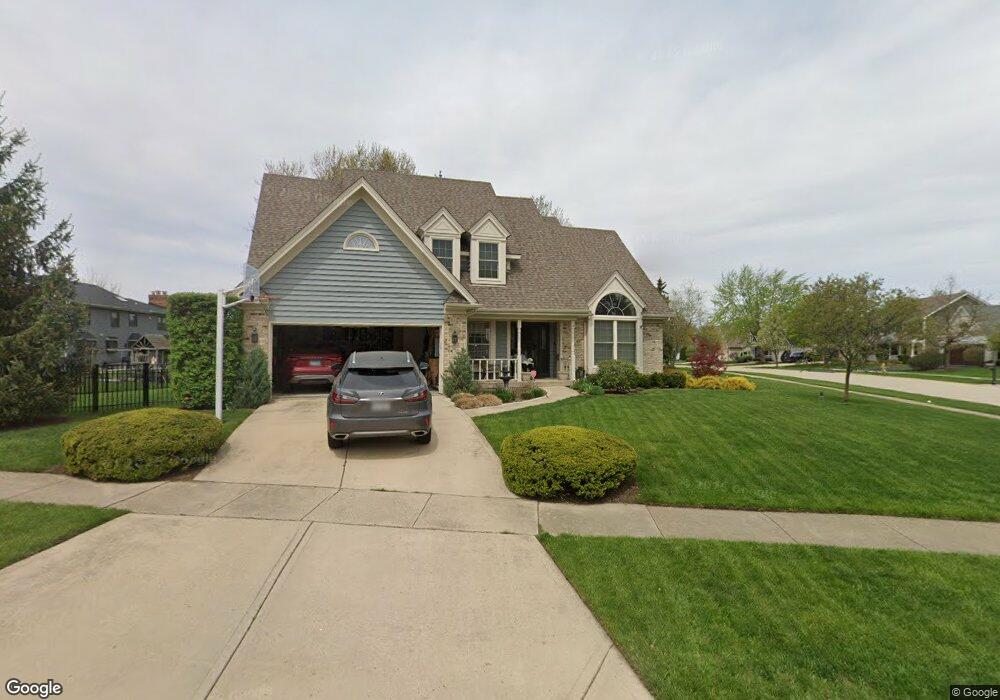
26W070 Pheasant Ct Carol Stream, IL 60188
Estimated Value: $713,000 - $732,000
4
Beds
3
Baths
2,805
Sq Ft
$258/Sq Ft
Est. Value
About This Home
This home is located at 26W070 Pheasant Ct, Carol Stream, IL 60188 and is currently estimated at $723,973, approximately $258 per square foot. 26W070 Pheasant Ct is a home located in DuPage County with nearby schools including Pleasant Hill Elementary School, Monroe Middle School, and Wheaton North High School.
Ownership History
Date
Name
Owned For
Owner Type
Purchase Details
Closed on
Mar 10, 2003
Sold by
Reichard David P and Reichard Karen L
Bought by
Tucker Mark C and Tucker Kathleen A
Current Estimated Value
Purchase Details
Closed on
Jun 27, 1994
Sold by
Gibbs Ronald J and Gibbs Donna S
Bought by
Reichard David P and Reichard Karen L
Home Financials for this Owner
Home Financials are based on the most recent Mortgage that was taken out on this home.
Original Mortgage
$180,000
Interest Rate
7.87%
Create a Home Valuation Report for This Property
The Home Valuation Report is an in-depth analysis detailing your home's value as well as a comparison with similar homes in the area
Home Values in the Area
Average Home Value in this Area
Purchase History
| Date | Buyer | Sale Price | Title Company |
|---|---|---|---|
| Tucker Mark C | $412,000 | Ctic | |
| Reichard David P | $307,500 | -- |
Source: Public Records
Mortgage History
| Date | Status | Borrower | Loan Amount |
|---|---|---|---|
| Previous Owner | Reichard David P | $180,000 |
Source: Public Records
Tax History Compared to Growth
Tax History
| Year | Tax Paid | Tax Assessment Tax Assessment Total Assessment is a certain percentage of the fair market value that is determined by local assessors to be the total taxable value of land and additions on the property. | Land | Improvement |
|---|---|---|---|---|
| 2024 | $11,327 | $195,302 | $51,756 | $143,546 |
| 2023 | $10,813 | $179,770 | $47,640 | $132,130 |
| 2022 | $10,714 | $169,890 | $45,020 | $124,870 |
| 2021 | $10,119 | $165,860 | $43,950 | $121,910 |
| 2020 | $9,961 | $164,310 | $43,540 | $120,770 |
| 2019 | $9,726 | $159,970 | $42,390 | $117,580 |
| 2018 | $10,317 | $167,370 | $39,950 | $127,420 |
| 2017 | $10,117 | $161,200 | $38,480 | $122,720 |
| 2016 | $9,953 | $154,760 | $36,940 | $117,820 |
| 2015 | $9,852 | $147,640 | $35,240 | $112,400 |
| 2014 | $9,572 | $141,520 | $37,120 | $104,400 |
| 2013 | $9,253 | $141,940 | $37,230 | $104,710 |
Source: Public Records
Map
Nearby Homes
- 26W185 Meadowview Ct
- 1N153 Mission Ct
- 26W137 Prestwick Ln
- 1N100 Harriet St
- 26W130 Prestwick Ln
- 26W181 Grand Ave
- 0N 634 Knollwood Dr
- 1N599 Golf View Ln
- 1N607 Golf View Ln
- 26W199 Klein Creek Dr
- 0N632 Gables Blvd
- 26W237 Pinehurst Dr
- 26W036 Klein Creek Dr Unit 36
- 0N510 Gary Ave
- S045 Pleasant Hill Rd
- 0N337 Herrick Dr
- 0N642 Alta Ln
- 25W277 Doris Ave
- 27W130 W Street Charles Rd
- Lot 2 W Street Charles Rd
- 1N050 Partridge Dr
- 1N051 Falcon Trail
- 1N020 Partridge Dr Unit 1
- 1N060 Partridge Dr
- 1N041 Partridge Dr
- 1N031 Partridge Dr
- 26W075 Pheasant Ct
- 1N061 Falcon Trail
- 1N051 Partridge Dr
- 1N021 Partridge Dr
- 1N104 Partridge Dr
- 1N061 Partridge Dr
- 1N061 Partridge Dr
- 1N010 Partridge Dr
- 1N103 Falcon Trail
- 26W103 Pheasant Ct
- 26W120 Pheasant Ct
- 1N054 Falcon Trail
- 1N042 Timothy Ln
- 1N101 Partridge Dr