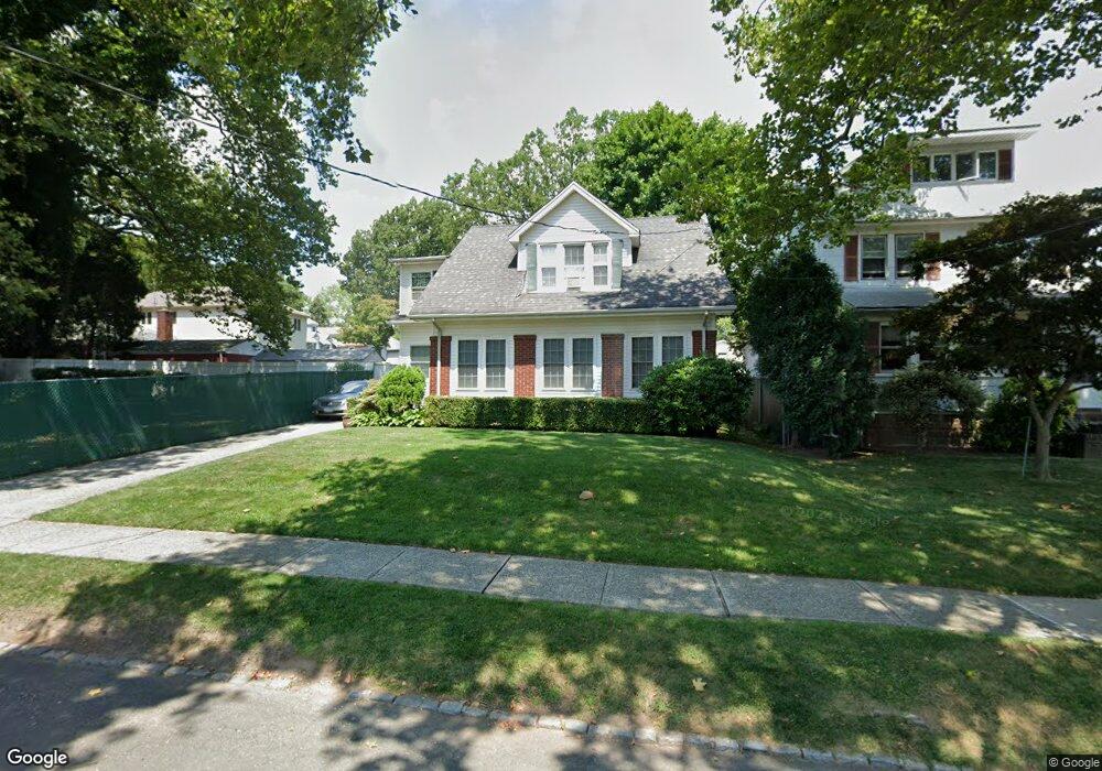
27 Amelia Ct Staten Island, NY 10310
Randall Manor NeighborhoodEstimated Value: $725,768 - $798,000
3
Beds
2
Baths
1,800
Sq Ft
$427/Sq Ft
Est. Value
About This Home
This home is located at 27 Amelia Ct, Staten Island, NY 10310 and is currently estimated at $769,192, approximately $427 per square foot. 27 Amelia Ct is a home located in Richmond County with nearby schools including P.S. 45 John Tyler, Is 61 William A Morris, and Curtis High School.
Ownership History
Date
Name
Owned For
Owner Type
Purchase Details
Closed on
Nov 27, 2007
Sold by
Mcvey Edward
Bought by
Jusino Ramon and Jusino Ann M
Current Estimated Value
Home Financials for this Owner
Home Financials are based on the most recent Mortgage that was taken out on this home.
Original Mortgage
$265,000
Outstanding Balance
$167,734
Interest Rate
6.3%
Mortgage Type
Purchase Money Mortgage
Estimated Equity
$601,458
Purchase Details
Closed on
Nov 1, 2002
Sold by
Mcvey Edward and Werring Mcvey Joan M
Bought by
Mcvey Edward
Home Financials for this Owner
Home Financials are based on the most recent Mortgage that was taken out on this home.
Original Mortgage
$175,000
Interest Rate
6.19%
Mortgage Type
Purchase Money Mortgage
Create a Home Valuation Report for This Property
The Home Valuation Report is an in-depth analysis detailing your home's value as well as a comparison with similar homes in the area
Home Values in the Area
Average Home Value in this Area
Purchase History
| Date | Buyer | Sale Price | Title Company |
|---|---|---|---|
| Jusino Ramon | $465,000 | None Available | |
| Mcvey Edward | -- | -- |
Source: Public Records
Mortgage History
| Date | Status | Borrower | Loan Amount |
|---|---|---|---|
| Open | Jusino Ramon | $265,000 | |
| Previous Owner | Mcvey Edward | $175,000 |
Source: Public Records
Tax History Compared to Growth
Tax History
| Year | Tax Paid | Tax Assessment Tax Assessment Total Assessment is a certain percentage of the fair market value that is determined by local assessors to be the total taxable value of land and additions on the property. | Land | Improvement |
|---|---|---|---|---|
| 2025 | $5,893 | $46,320 | $7,017 | $39,303 |
| 2024 | $5,905 | $41,640 | $7,486 | $34,154 |
| 2023 | $5,606 | $29,002 | $6,526 | $22,476 |
| 2022 | $5,175 | $43,620 | $10,140 | $33,480 |
| 2021 | $5,455 | $38,580 | $10,140 | $28,440 |
| 2020 | $5,358 | $36,480 | $10,140 | $26,340 |
| 2019 | $5,066 | $36,900 | $10,140 | $26,760 |
| 2018 | $4,629 | $24,168 | $8,024 | $16,144 |
| 2017 | $4,348 | $22,800 | $10,140 | $12,660 |
| 2016 | $4,407 | $23,595 | $9,632 | $13,963 |
| 2015 | $3,826 | $22,260 | $8,460 | $13,800 |
| 2014 | $3,826 | $21,524 | $8,180 | $13,344 |
Source: Public Records
Map
Nearby Homes
- 110 Kissel Ave
- 144 Bard Ave Unit 25b
- 160 Bard Ave Unit 6A
- 154 Bard Ave Unit 14A
- 188 Davis Ave
- 21 Elizabeth Ave
- 16 Howard Ct
- 11 Curtis Ct
- 154 Pelton Ave
- 4 Brentwood Ave
- 44 Westbury Ave
- 163 Bement Ave
- 70 Elm St
- 84 Elm St
- 125 Tysen St
- 148 Clinton Ave
- 152 Clinton Ave
- 699 Henderson Ave
- 230 Fillmore St
- 126 Cassidy Place Unit H2