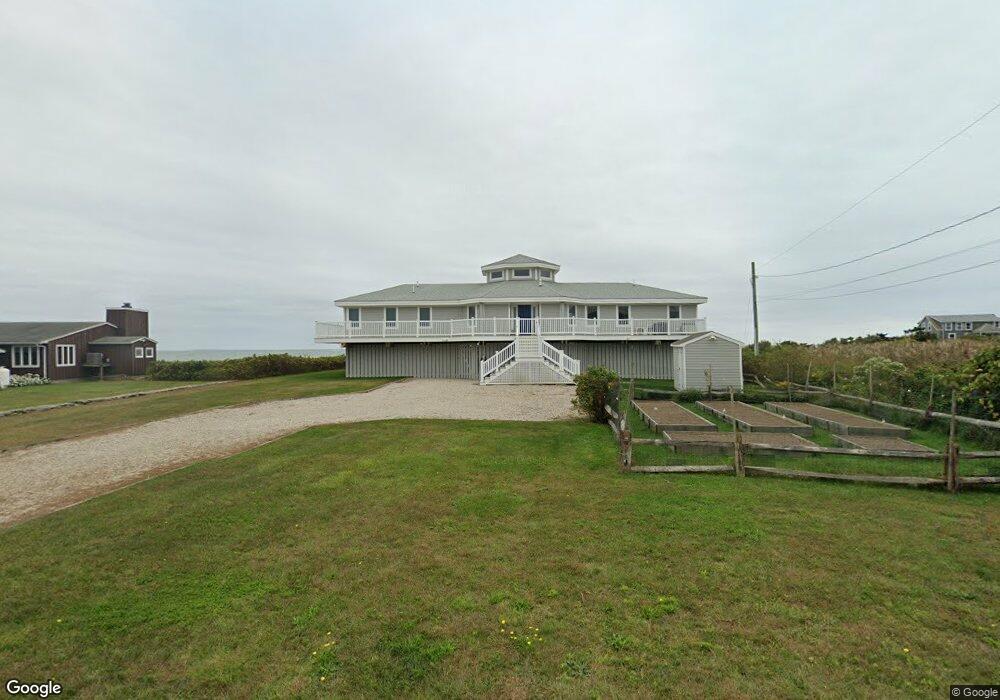
27 Atlantic Ave Westport, MA 02790
Acoaxet NeighborhoodEstimated Value: $2,824,000 - $3,322,233
3
Beds
1
Bath
2,291
Sq Ft
$1,316/Sq Ft
Est. Value
About This Home
This home is located at 27 Atlantic Ave, Westport, MA 02790 and is currently estimated at $3,015,078, approximately $1,316 per square foot. 27 Atlantic Ave is a home located in Bristol County with nearby schools including Alice A. Macomber Primary School, Westport Elementary School, and Westport Middle-High School.
Ownership History
Date
Name
Owned For
Owner Type
Purchase Details
Closed on
Sep 16, 2011
Sold by
Judith A Roth Ret
Bought by
Roth Ft
Current Estimated Value
Purchase Details
Closed on
Dec 3, 2009
Sold by
Roth Judith A
Bought by
Judith A Roth Ret
Purchase Details
Closed on
Aug 8, 1997
Sold by
Saunders Albert D and Saunders Valerie J
Bought by
Roth Bruce L
Home Financials for this Owner
Home Financials are based on the most recent Mortgage that was taken out on this home.
Original Mortgage
$425,000
Interest Rate
7.38%
Create a Home Valuation Report for This Property
The Home Valuation Report is an in-depth analysis detailing your home's value as well as a comparison with similar homes in the area
Home Values in the Area
Average Home Value in this Area
Purchase History
| Date | Buyer | Sale Price | Title Company |
|---|---|---|---|
| Roth Ft | -- | -- | |
| Judith A Roth Ret | -- | -- | |
| Roth Bruce L | $535,000 | -- |
Source: Public Records
Mortgage History
| Date | Status | Borrower | Loan Amount |
|---|---|---|---|
| Previous Owner | Roth Bruce L | $422,000 | |
| Previous Owner | Roth Bruce L | $425,000 | |
| Previous Owner | Roth Bruce L | $425,000 |
Source: Public Records
Tax History Compared to Growth
Tax History
| Year | Tax Paid | Tax Assessment Tax Assessment Total Assessment is a certain percentage of the fair market value that is determined by local assessors to be the total taxable value of land and additions on the property. | Land | Improvement |
|---|---|---|---|---|
| 2025 | $20,891 | $2,804,200 | $1,928,000 | $876,200 |
| 2024 | $18,152 | $2,348,200 | $1,786,300 | $561,900 |
| 2023 | $17,739 | $2,173,900 | $1,701,200 | $472,700 |
| 2022 | $17,567 | $2,071,600 | $1,701,200 | $370,400 |
| 2021 | $3,480 | $1,916,900 | $1,546,500 | $370,400 |
| 2020 | $15,638 | $1,855,100 | $1,484,700 | $370,400 |
| 2019 | $15,413 | $1,863,700 | $1,484,700 | $379,000 |
| 2018 | $15,207 | $1,861,300 | $1,594,600 | $266,700 |
| 2017 | $16,173 | $2,029,200 | $1,771,700 | $257,500 |
| 2016 | $16,797 | $2,123,500 | $1,889,900 | $233,600 |
| 2015 | $16,597 | $2,092,900 | $1,889,900 | $203,000 |
Source: Public Records
Map
Nearby Homes
- 304 Brayton Point Rd
- 189 Brayton Point Rd
- 19 Seabury Ln
- 255 John Dyer Rd
- 18 Old Barn Rd
- 1881 Main Rd
- 0 Reed Rd (Ss)
- 128 Maple Ave
- 1580 Main Rd
- 245 John Dyer Rd
- 1702J Drift Rd
- 505 Long Hwy
- 1702 Drift Rd
- 141 S Of Commons Rd
- 1346 Main Rd Unit B
- 0 Willow Ave
- 17 Quail Trail
- 116 Amy Hart Path
- 238-242 E Beach Rd
- 536 W Main Rd
- 31 Atlantic Ave
- 5 Atlantic Ave
- 20 Atlantic Ave
- 42 Atlantic Ave
- 42 Atlantic Ave
- 18 Atlantic Ave
- 39 Atlantic Ave
- 12 Atlantic Ave
- 13 Atlantic Ave
- 8 Atlantic Ave
- 12 Lakeside Ave Unit 14
- 46 Hillside Rd
- 52 Hillside Rd
- 2 Atlantic Ave
- 20 Lakeside Ave
- 278 Howland Rd
- 43 Hillside Rd
- 0 Atlantic Ave
- 55 Hillside Rd
- 36 Hillside Rd