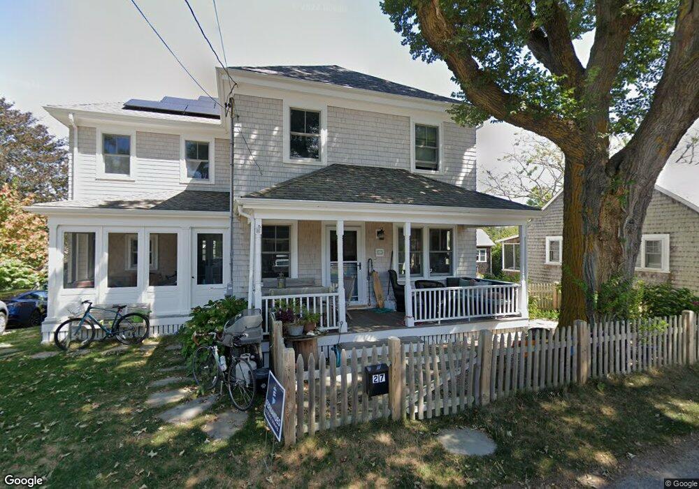
27 Bar Neck Rd Falmouth, MA 2543
Woods Hole NeighborhoodEstimated Value: $1,550,000 - $2,124,502
4
Beds
3
Baths
3,204
Sq Ft
$587/Sq Ft
Est. Value
About This Home
This home is located at 27 Bar Neck Rd, Falmouth, MA 2543 and is currently estimated at $1,879,626, approximately $586 per square foot. 27 Bar Neck Rd is a home located in Barnstable County with nearby schools including Mullen-Hall School, Lawrence School, and Morse Pond School.
Ownership History
Date
Name
Owned For
Owner Type
Purchase Details
Closed on
Jan 23, 2013
Sold by
Greene Amy L and Polk Jennifer
Bought by
Polk Jennifer and Greene Amy L
Current Estimated Value
Purchase Details
Closed on
Sep 5, 1997
Sold by
Zarker Jean Alice and Grinnell Caroline J
Bought by
27 Barn Neck Rd Rt and Greene
Create a Home Valuation Report for This Property
The Home Valuation Report is an in-depth analysis detailing your home's value as well as a comparison with similar homes in the area
Home Values in the Area
Average Home Value in this Area
Purchase History
| Date | Buyer | Sale Price | Title Company |
|---|---|---|---|
| Polk Jennifer | -- | -- | |
| Polk Jennifer | -- | -- | |
| 27 Barn Neck Rd Rt | $250,000 | -- | |
| 27 Barn Neck Rd Rt | $250,000 | -- |
Source: Public Records
Mortgage History
| Date | Status | Borrower | Loan Amount |
|---|---|---|---|
| Previous Owner | 27 Barn Neck Rd Rt | $207,200 | |
| Previous Owner | 27 Barn Neck Rd Rt | $225,000 | |
| Previous Owner | 27 Barn Neck Rd Rt | $150,000 |
Source: Public Records
Tax History Compared to Growth
Tax History
| Year | Tax Paid | Tax Assessment Tax Assessment Total Assessment is a certain percentage of the fair market value that is determined by local assessors to be the total taxable value of land and additions on the property. | Land | Improvement |
|---|---|---|---|---|
| 2025 | $9,127 | $1,554,800 | $726,000 | $828,800 |
| 2024 | $8,607 | $1,370,600 | $631,300 | $739,300 |
| 2023 | $6,178 | $892,800 | $631,300 | $261,500 |
| 2022 | $6,648 | $825,900 | $616,800 | $209,100 |
| 2021 | $6,555 | $771,200 | $590,000 | $181,200 |
| 2020 | $6,163 | $717,500 | $536,300 | $181,200 |
| 2019 | $6,127 | $715,800 | $536,300 | $179,500 |
| 2018 | $6,051 | $703,600 | $536,300 | $167,300 |
| 2017 | $5,961 | $698,800 | $536,300 | $162,500 |
| 2016 | $5,849 | $698,800 | $536,300 | $162,500 |
| 2015 | $5,723 | $698,800 | $536,300 | $162,500 |
| 2014 | $5,695 | $698,800 | $536,500 | $162,300 |
Source: Public Records
Map
Nearby Homes
- 5 Park Rd
- 14 School St
- 10 Quissett Ave
- 82 Harbor Hill Rd
- 54 Whitman Rd
- 533 Woods Hole Rd Unit B101
- 533 Woods Hole Rd Unit D101
- 533 Woods Hole Rd Unit B102
- 533 Woods Hole Rd Unit E202
- 533 Woods Hole Rd Unit E301
- 9 Strawberry Hill Rd
- 9 Strawberry Hill Rd
- 29 Wilson Rd
- 76 F r Lillie Rd
- 251 Woods Hole Rd
- 44 Carey Ln
- 87 Oyster Pond Rd
- 38 Landfall Unit 38
- 38 Landfall
- 27 Bar Neck Rd
- 25 Bar Neck Rd
- 31 Bar Neck Rd
- 31 Bar Neck Rd
- 34 Albatross St
- 38 Albatross St
- 32 Bar Neck Rd
- 28 Bar Neck Rd
- 28 Bar Neck Rd
- 26 Bar Neck Rd
- 10 Spencer Baird Rd
- 32 Bar Neck Rd
- 30 Albatross St
- 26 Albatross St
- 17 North St
- 33 Bar Neck Rd
- 16 Spencer Baird Rd
- 16 Spencer Baird Rd
- 27 Albatross St
- 40 Bar Neck Rd