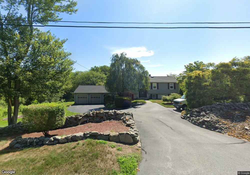
27 Blanding Rd Rehoboth, MA 02769
Estimated Value: $526,000 - $670,000
3
Beds
2
Baths
1,962
Sq Ft
$309/Sq Ft
Est. Value
About This Home
This home is located at 27 Blanding Rd, Rehoboth, MA 02769 and is currently estimated at $605,912, approximately $308 per square foot. 27 Blanding Rd is a home located in Bristol County with nearby schools including Dighton-Rehoboth Regional High School, St Margaret School, and Cedar Brook School.
Ownership History
Date
Name
Owned For
Owner Type
Purchase Details
Closed on
Feb 4, 2025
Sold by
Martel Steven G and Martel Karen L
Bought by
Steven G & K L Martel Irt and Martel
Current Estimated Value
Purchase Details
Closed on
Sep 4, 1997
Sold by
Zebro Anthony A and Zebro Ann F
Bought by
Benaski Debra
Purchase Details
Closed on
Oct 21, 1994
Sold by
Benaski Daniel J and Benaski Debra A
Bought by
Martel Steven G and Martel Karen L
Create a Home Valuation Report for This Property
The Home Valuation Report is an in-depth analysis detailing your home's value as well as a comparison with similar homes in the area
Home Values in the Area
Average Home Value in this Area
Purchase History
| Date | Buyer | Sale Price | Title Company |
|---|---|---|---|
| Steven G & K L Martel Irt | -- | None Available | |
| Steven G & K L Martel Irt | -- | None Available | |
| Benaski Debra | $55,000 | -- | |
| Benaski Debra | $55,000 | -- | |
| Martel Steven G | $161,000 | -- | |
| Martel Steven G | $161,000 | -- |
Source: Public Records
Mortgage History
| Date | Status | Borrower | Loan Amount |
|---|---|---|---|
| Previous Owner | Martel Steven G | $135,000 | |
| Previous Owner | Martel Steven G | $145,500 |
Source: Public Records
Tax History Compared to Growth
Tax History
| Year | Tax Paid | Tax Assessment Tax Assessment Total Assessment is a certain percentage of the fair market value that is determined by local assessors to be the total taxable value of land and additions on the property. | Land | Improvement |
|---|---|---|---|---|
| 2025 | $5,555 | $498,200 | $191,500 | $306,700 |
| 2024 | $5,335 | $469,600 | $191,500 | $278,100 |
| 2023 | $4,864 | $443,800 | $187,500 | $256,300 |
| 2022 | $4,864 | $383,900 | $179,100 | $204,800 |
| 2021 | $4,736 | $357,700 | $162,800 | $194,900 |
| 2020 | $4,355 | $331,900 | $162,800 | $169,100 |
| 2018 | $3,759 | $314,000 | $155,000 | $159,000 |
| 2017 | $3,717 | $295,900 | $155,000 | $140,900 |
| 2016 | $3,644 | $299,900 | $155,000 | $144,900 |
| 2015 | $3,492 | $283,700 | $147,800 | $135,900 |
| 2014 | $3,263 | $262,300 | $140,600 | $121,700 |
Source: Public Records
Map
Nearby Homes
- 9 Hidden Hills Dr
- 25 Lincoln St
- 23 Colonial Way
- 37 Colonial Way
- 824 Taunton Ave
- 16 Salisbury St
- 67 Wheeler St
- 181 Hope St
- 420 Chestnut St
- 0 Patterson St Unit 73348933
- 15 Hickory Ridge Rd
- 6 Running Stream Rd
- 181 Sherman Ave
- 0 Winter St
- 111 Summer St
- 42 Tee Jay Dr
- 20 School St
- 25 Pimental Dr
- 57 Redwood Ln
- 224 Arcade Ave
- 30 Blanding Rd
- 23 Blanding Rd
- 34 Blanding Rd
- 26 Blanding Rd
- 19 Blanding Rd
- 36 Blanding Rd
- 20 Blanding Rd
- 37 Blanding Rd Unit 39
- 15 Blanding Rd
- 570 Winthrop St
- 16 Blanding Rd
- 12 Blanding Rd
- 44 Blanding Rd
- 11 Blanding Rd
- 576 Winthrop St
- 578 Winthrop St
- 569 Winthrop St Unit 2
- 569 Winthrop St Unit 3
- 569 Winthrop St Unit 1
- 7 Blanding Rd