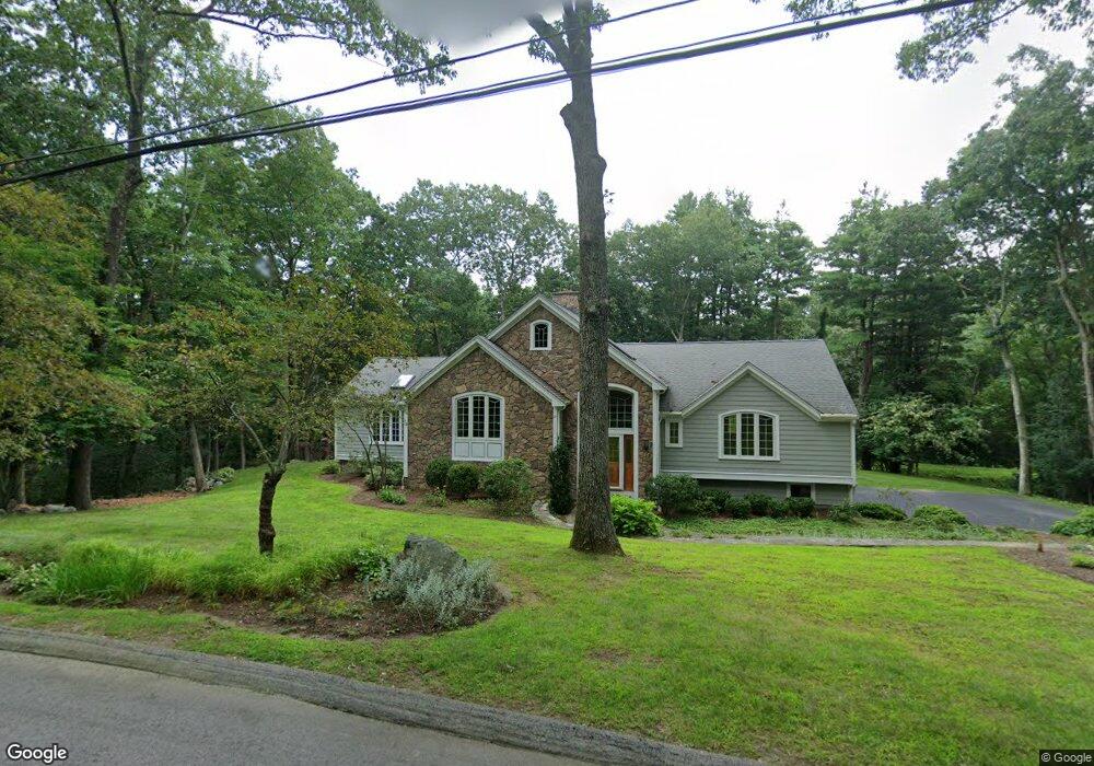
27 Clubhouse Ln Wayland, MA 01778
Estimated Value: $1,175,000 - $1,470,000
3
Beds
4
Baths
2,823
Sq Ft
$483/Sq Ft
Est. Value
About This Home
This home is located at 27 Clubhouse Ln, Wayland, MA 01778 and is currently estimated at $1,362,494, approximately $482 per square foot. 27 Clubhouse Ln is a home with nearby schools including Natick High School, Bennett-Hemenway (Ben-Hem) Elementary School, and Wilson Middle School.
Ownership History
Date
Name
Owned For
Owner Type
Purchase Details
Closed on
Aug 29, 2017
Sold by
Bourassa Peter and Bourassa Dorothy E
Bought by
Bourassa Dorothy E
Current Estimated Value
Purchase Details
Closed on
Jun 27, 1991
Sold by
Roberts Alan and Roberts Nancy
Bought by
Bourassa Peter and Bourassa Dorothy E
Create a Home Valuation Report for This Property
The Home Valuation Report is an in-depth analysis detailing your home's value as well as a comparison with similar homes in the area
Home Values in the Area
Average Home Value in this Area
Purchase History
| Date | Buyer | Sale Price | Title Company |
|---|---|---|---|
| Bourassa Dorothy E | -- | -- | |
| Bourassa Peter | $313,000 | -- |
Source: Public Records
Mortgage History
| Date | Status | Borrower | Loan Amount |
|---|---|---|---|
| Previous Owner | Bourassa Peter | $88,000 | |
| Previous Owner | Bourassa Peter | $26,000 | |
| Previous Owner | Bourassa Peter | $242,000 |
Source: Public Records
Tax History Compared to Growth
Tax History
| Year | Tax Paid | Tax Assessment Tax Assessment Total Assessment is a certain percentage of the fair market value that is determined by local assessors to be the total taxable value of land and additions on the property. | Land | Improvement |
|---|---|---|---|---|
| 2025 | $14,467 | $1,209,600 | $517,700 | $691,900 |
| 2024 | $13,862 | $1,130,700 | $489,100 | $641,600 |
| 2023 | $13,400 | $1,060,100 | $454,100 | $606,000 |
| 2022 | $12,700 | $952,000 | $408,900 | $543,100 |
| 2021 | $12,166 | $893,900 | $386,500 | $507,400 |
| 2020 | $11,937 | $877,100 | $369,700 | $507,400 |
| 2019 | $11,148 | $877,100 | $369,700 | $507,400 |
| 2018 | $11,498 | $881,100 | $352,900 | $528,200 |
| 2017 | $11,612 | $860,800 | $342,100 | $518,700 |
| 2016 | $11,613 | $855,800 | $342,100 | $513,700 |
| 2015 | $11,671 | $844,500 | $342,100 | $502,400 |
Source: Public Records
Map
Nearby Homes
- 17 Smokey Hill Rd
- 106 Willow Brook Dr Unit 106
- 8 Frost St
- 12 Nancy Rd
- 12 Cutting Cross Way
- 125 Woodridge Rd
- 18 Coltsway Unit 18
- 6 Steepletree Ln
- 1 Winter St
- 5 Brook Trail Rd
- 11 White Pine Knoll Rd
- 22 Fox Hill Dr
- 168 Beaver Rd
- 5 Upham Way Unit 5
- 9 Christina
- 286 Country Dr
- 606 Wisteria Way
- 35 Snake Brook Rd
- 7 Fox Hollow
- 8 Fox Hollow
- 23 Clubhouse Ln
- 29 Clubhouse Ln
- 28 Clubhouse Ln
- 32 Clubhouse Ln
- 32 Clubhouse Ln Unit 1
- 466 Commonwealth Rd
- 22 Clubhouse Ln
- 468 Commonwealth Rd
- 33 Clubhouse Ln
- 470 Commonwealth Rd(off Of)
- 21 Clubhouse Ln
- 470 Commonwealth Rd
- 472 Commonwealth Rd
- 20 Clubhouse Ln
- 19 Clubhouse Ln
- 15 Linn Ln
- 17 Clubhouse Ln
- 38 Clubhouse Ln
- 37 Clubhouse Ln
- 474 Commonwealth Rd