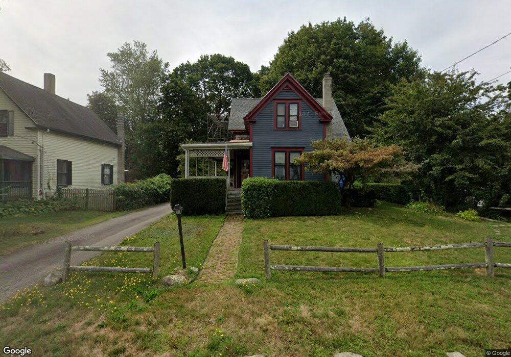
27 George St Rockland, MA 02370
Estimated Value: $476,000 - $579,000
3
Beds
2
Baths
1,158
Sq Ft
$442/Sq Ft
Est. Value
About This Home
This home is located at 27 George St, Rockland, MA 02370 and is currently estimated at $512,231, approximately $442 per square foot. 27 George St is a home located in Plymouth County with nearby schools including Rockland Senior High School, Calvary Chapel Academy, and Holy Family Elementary School.
Ownership History
Date
Name
Owned For
Owner Type
Purchase Details
Closed on
Dec 1, 1993
Sold by
Sullivan John P and Sullivan Darlene G
Bought by
Corbett Michael P and Corbett Eugenia M
Current Estimated Value
Home Financials for this Owner
Home Financials are based on the most recent Mortgage that was taken out on this home.
Original Mortgage
$117,000
Interest Rate
6.69%
Mortgage Type
Purchase Money Mortgage
Create a Home Valuation Report for This Property
The Home Valuation Report is an in-depth analysis detailing your home's value as well as a comparison with similar homes in the area
Home Values in the Area
Average Home Value in this Area
Purchase History
| Date | Buyer | Sale Price | Title Company |
|---|---|---|---|
| Corbett Michael P | $125,000 | -- |
Source: Public Records
Mortgage History
| Date | Status | Borrower | Loan Amount |
|---|---|---|---|
| Open | Corbett Michael P | $100,300 | |
| Closed | Corbett Michael P | $117,000 | |
| Previous Owner | Corbett Michael P | $20,000 | |
| Previous Owner | Corbett Michael P | $5,000 |
Source: Public Records
Tax History Compared to Growth
Tax History
| Year | Tax Paid | Tax Assessment Tax Assessment Total Assessment is a certain percentage of the fair market value that is determined by local assessors to be the total taxable value of land and additions on the property. | Land | Improvement |
|---|---|---|---|---|
| 2025 | $5,609 | $410,300 | $227,000 | $183,300 |
| 2024 | $5,445 | $387,300 | $214,100 | $173,200 |
| 2023 | $5,263 | $345,800 | $186,600 | $159,200 |
| 2022 | $5,043 | $301,100 | $162,200 | $138,900 |
| 2021 | $4,657 | $269,500 | $147,500 | $122,000 |
| 2020 | $4,496 | $256,900 | $140,500 | $116,400 |
| 2019 | $4,394 | $245,200 | $133,800 | $111,400 |
| 2018 | $4,185 | $229,700 | $133,800 | $95,900 |
| 2017 | $3,966 | $214,600 | $126,800 | $87,800 |
| 2016 | $3,818 | $206,500 | $121,900 | $84,600 |
| 2015 | $3,760 | $197,600 | $113,900 | $83,700 |
| 2014 | $3,596 | $196,100 | $111,700 | $84,400 |
Source: Public Records
Map
Nearby Homes
- 94-96 Crescent St
- 23 Payson Ave
- 44 Albion St
- 440 Market St
- 49 Liberty St
- 45-47 Park St
- 149 Concord St
- 103 Grove St Unit 337
- 3 Kasey Ln Unit 3
- 122 Reed St
- 119 Grove St Unit 223
- 119 Grove St Unit 238
- 225 W Water St
- 59 Spring St
- 21 Archer Rd
- 354 Webster St
- 4 Phillips St
- 17-23 Dyer St Unit 17
- 5 Clark Rd
- 86 Damon Rd