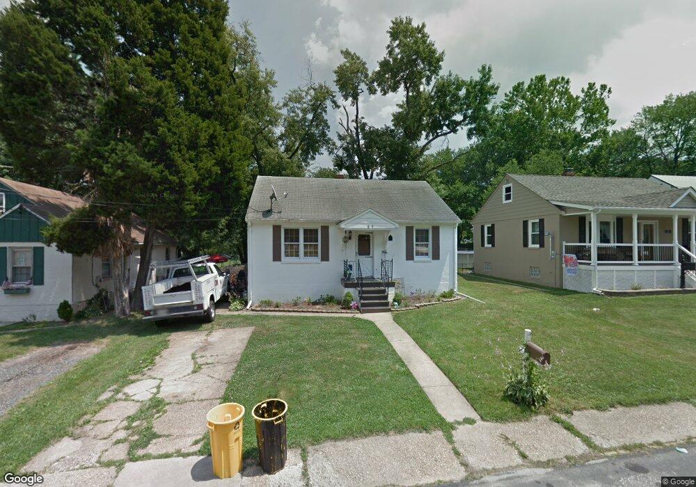
27 Hampton Rd Linthicum Heights, MD 21090
Estimated Value: $357,972 - $402,000
Studio
1
Bath
1,344
Sq Ft
$281/Sq Ft
Est. Value
About This Home
This home is located at 27 Hampton Rd, Linthicum Heights, MD 21090 and is currently estimated at $377,743, approximately $281 per square foot. 27 Hampton Rd is a home located in Anne Arundel County with nearby schools including Overlook Elementary School, Lindale Middle School, and North County High School.
Ownership History
Date
Name
Owned For
Owner Type
Purchase Details
Closed on
Jun 9, 2004
Sold by
Rupprecht Ryan S
Bought by
Russell Tracey A
Current Estimated Value
Purchase Details
Closed on
Apr 12, 1999
Sold by
Hall Steven M
Bought by
Rupprecht Ryan S and Rupprecht Naomi F
Purchase Details
Closed on
Apr 26, 1993
Sold by
Harman Lydia E
Bought by
Hall Steven M
Home Financials for this Owner
Home Financials are based on the most recent Mortgage that was taken out on this home.
Original Mortgage
$96,900
Interest Rate
7.38%
Create a Home Valuation Report for This Property
The Home Valuation Report is an in-depth analysis detailing your home's value as well as a comparison with similar homes in the area
Home Values in the Area
Average Home Value in this Area
Purchase History
| Date | Buyer | Sale Price | Title Company |
|---|---|---|---|
| Russell Tracey A | $198,000 | -- | |
| Rupprecht Ryan S | $115,000 | -- | |
| Hall Steven M | $102,000 | -- |
Source: Public Records
Mortgage History
| Date | Status | Borrower | Loan Amount |
|---|---|---|---|
| Previous Owner | Hall Steven M | $96,900 | |
| Closed | Rupprecht Ryan S | -- |
Source: Public Records
Tax History
| Year | Tax Paid | Tax Assessment Tax Assessment Total Assessment is a certain percentage of the fair market value that is determined by local assessors to be the total taxable value of land and additions on the property. | Land | Improvement |
|---|---|---|---|---|
| 2025 | $2,613 | $286,900 | $151,800 | $135,100 |
| 2024 | $2,613 | $274,433 | $0 | $0 |
| 2023 | $2,530 | $261,967 | $0 | $0 |
| 2022 | $2,355 | $249,500 | $136,800 | $112,700 |
| 2020 | $2,230 | $231,967 | $0 | $0 |
| 2019 | $2,191 | $223,200 | $108,400 | $114,800 |
| 2018 | $2,237 | $220,567 | $0 | $0 |
| 2017 | $2,075 | $217,933 | $0 | $0 |
| 2016 | -- | $215,300 | $0 | $0 |
| 2015 | -- | $215,300 | $0 | $0 |
| 2014 | -- | $215,300 | $0 | $0 |
Source: Public Records
Map
Nearby Homes
- 31 Governors Gate Ln
- 404 Carl Ave
- 451 Susan Ct
- 100 Governors Gate Ln
- 6028 Belle Grove Rd
- P298 & P263 Nursery Rd
- 312 Elizabeth Ave
- 5904 Belle Grove Rd
- 145 Shenandoah Ave
- 307 Key Ave
- 300 Twin Oaks Rd
- 312 N Hammonds Ferry Rd
- 518 N Rd
- 105 Michael Ave
- 2773 Yarnall Rd
- 2752 Norfen Rd
- 4435 Scotia Rd
- 4415 Norfen Rd
- 5722 Howard Dr
- 715 Hammonds Ln
Your Personal Tour Guide
Ask me questions while you tour the home.