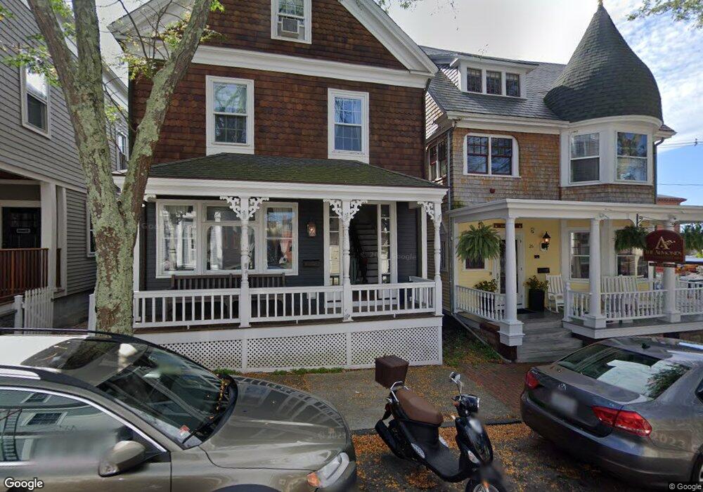
27 Pelham St Newport, RI 02840
Historic Hill NeighborhoodEstimated Value: $963,000 - $1,137,000
4
Beds
2
Baths
1,647
Sq Ft
$656/Sq Ft
Est. Value
About This Home
This home is located at 27 Pelham St, Newport, RI 02840 and is currently estimated at $1,080,375, approximately $655 per square foot. 27 Pelham St is a home located in Newport County with nearby schools including Rogers High School, St Michael's Country Day School, and St George's School.
Ownership History
Date
Name
Owned For
Owner Type
Purchase Details
Closed on
Feb 5, 2018
Sold by
Pivotal Enterprises 1
Bought by
Pelham 191 Llc
Current Estimated Value
Purchase Details
Closed on
Mar 19, 2014
Sold by
Drolet 3Rd William A and Donnellan Thomas P
Bought by
Pivotal Enterprises 1
Purchase Details
Closed on
Mar 12, 2013
Sold by
Pivotal Enterprises 1
Bought by
Drolet 3Rd William A and Donnellan Thomas P
Purchase Details
Closed on
May 8, 2000
Sold by
Helme Jay E and Helme Nancy G
Bought by
Donnellan Thomas P and Drolet William A
Create a Home Valuation Report for This Property
The Home Valuation Report is an in-depth analysis detailing your home's value as well as a comparison with similar homes in the area
Home Values in the Area
Average Home Value in this Area
Purchase History
| Date | Buyer | Sale Price | Title Company |
|---|---|---|---|
| Pelham 191 Llc | -- | -- | |
| Pivotal Enterprises 1 | -- | -- | |
| Drolet 3Rd William A | -- | -- | |
| Donnellan Thomas P | $215,000 | -- |
Source: Public Records
Mortgage History
| Date | Status | Borrower | Loan Amount |
|---|---|---|---|
| Previous Owner | Donnellan Thomas P | $230,533 | |
| Previous Owner | Donnellan Thomas P | $212,000 | |
| Previous Owner | Donnellan Thomas P | $107,500 |
Source: Public Records
Tax History Compared to Growth
Tax History
| Year | Tax Paid | Tax Assessment Tax Assessment Total Assessment is a certain percentage of the fair market value that is determined by local assessors to be the total taxable value of land and additions on the property. | Land | Improvement |
|---|---|---|---|---|
| 2025 | $7,912 | $910,600 | $349,900 | $560,700 |
| 2024 | $7,485 | $910,600 | $349,900 | $560,700 |
| 2023 | $5,884 | $593,100 | $228,800 | $364,300 |
| 2022 | $5,700 | $593,100 | $228,800 | $364,300 |
| 2021 | $5,534 | $593,100 | $228,800 | $364,300 |
| 2020 | $5,007 | $487,100 | $217,900 | $269,200 |
| 2019 | $5,007 | $487,100 | $217,900 | $269,200 |
| 2018 | $4,763 | $476,800 | $217,900 | $258,900 |
| 2017 | $4,076 | $363,600 | $155,800 | $207,800 |
| 2016 | $3,974 | $363,600 | $155,800 | $207,800 |
| 2015 | $3,880 | $363,600 | $155,800 | $207,800 |
| 2014 | $4,079 | $338,200 | $132,400 | $205,800 |
Source: Public Records
Map
Nearby Homes
- 26 Franklin St
- 75 Pelham St Unit B
- 130 Spring St Unit 132
- 50 School St Unit 7
- 75 Mary St
- 30 Brewer St Unit 3
- 10 Barney St Unit 102
- 10 Barney St Unit 107
- 10 Barney St Unit 101
- 10 Barney St Unit U106
- 12 Mount Vernon St Unit 5
- 24 Brown and Howard Wharf Unit 301
- 28 Young St
- 34 Bull St
- 8 Cottage St Unit 2
- 31 Coddington St Unit 24
- 27 Soar Way
- 24 Old Beach Rd
- 33 Kay St
- 102 Broadway Unit 2B
- 25 Pelham St
- 29 Pelham St
- 32 Green St
- 34 Green St
- 34 Green St Unit 1
- 35 Pelham St Unit 4G
- 35 Pelham St Unit A
- 35 Pelham St Unit PHE
- 35 Pelham St Unit B
- 35 Pelham St Unit D
- 35 Pelham St Unit C
- 35 Pelham St Unit PHW
- 35 Pelham St Unit 3G
- 35 Pelham St Unit 2G
- 35 Pelham St Unit 1G
- 35 Pelham St Unit E+3G
- 35 Pelham St
- 35 Pelham St Unit B+1G
- 35 Pelham St Unit A -1G
- 35 Pelham St Unit PHW 4G