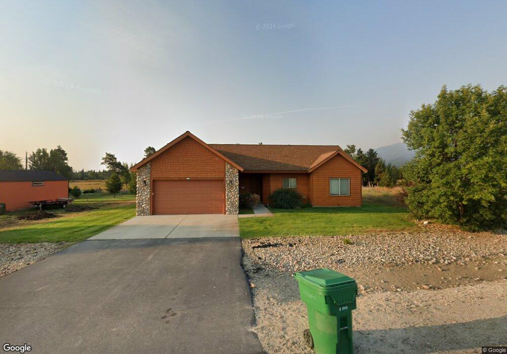
27 Price St Donnelly, ID 83615
Estimated Value: $462,000 - $521,000
3
Beds
1
Bath
1,716
Sq Ft
$286/Sq Ft
Est. Value
About This Home
This home is located at 27 Price St, Donnelly, ID 83615 and is currently estimated at $490,797, approximately $286 per square foot. 27 Price St is a home with nearby schools including Donnelly Elementary School and McCall-Donnelly High School.
Ownership History
Date
Name
Owned For
Owner Type
Purchase Details
Closed on
Jun 6, 2012
Sold by
Taggart Lava Rock Llc
Bought by
Taggart Steven L
Current Estimated Value
Purchase Details
Closed on
Aug 23, 2006
Sold by
Timberline Development Llc
Bought by
Taggart Steven L
Home Financials for this Owner
Home Financials are based on the most recent Mortgage that was taken out on this home.
Original Mortgage
$156,000
Interest Rate
6.22%
Mortgage Type
New Conventional
Create a Home Valuation Report for This Property
The Home Valuation Report is an in-depth analysis detailing your home's value as well as a comparison with similar homes in the area
Home Values in the Area
Average Home Value in this Area
Purchase History
| Date | Buyer | Sale Price | Title Company |
|---|---|---|---|
| Taggart Steven L | -- | None Available | |
| Taggart Steven L | -- | -- |
Source: Public Records
Mortgage History
| Date | Status | Borrower | Loan Amount |
|---|---|---|---|
| Previous Owner | Taggart Steven L | $156,000 |
Source: Public Records
Tax History Compared to Growth
Tax History
| Year | Tax Paid | Tax Assessment Tax Assessment Total Assessment is a certain percentage of the fair market value that is determined by local assessors to be the total taxable value of land and additions on the property. | Land | Improvement |
|---|---|---|---|---|
| 2025 | $1,210 | $437,895 | $28,181 | $409,714 |
| 2023 | $1,210 | $494,461 | $29,075 | $465,386 |
| 2022 | $1,337 | $439,642 | $29,075 | $410,567 |
| 2021 | $1,234 | $259,215 | $22,366 | $236,849 |
| 2020 | $1,192 | $209,077 | $29,413 | $179,664 |
| 2019 | $1,018 | $163,277 | $28,012 | $135,265 |
| 2018 | $1,008 | $152,749 | $28,507 | $124,242 |
| 2017 | $1,080 | $149,762 | $31,420 | $118,342 |
| 2016 | $977 | $132,722 | $25,000 | $107,722 |
| 2015 | $859 | $109,914 | $0 | $0 |
| 2013 | -- | $106,968 | $0 | $0 |
Source: Public Records
Map
Nearby Homes
- 16 Buckskin Dr
- 22 Charters Dr
- 13078 Hill House Loop
- 13111 Cameron Dr
- 13076 Hill House Loop
- 13091 Hill House Loop
- 13098 Hill House Loop
- 106 Forest Place
- Lot 4 Hideout Dr Unit 4
- Lot 6 Hideout Dr Unit 6
- 24 Mangum Cir Unit 1
- 20 #5 W Mangum Cir Unit 5
- 20 Mangum Cir Unit 8
- 24 Mangum Dr Unit # 1 Unit 1
- 120 Forest Place
- 13038 Hill House Loop
- 35 1 Mangum Cir
- 126 Forest Place
- 35 Mangum Cir Unit 1
- 32 Mangum Cir Unit 3