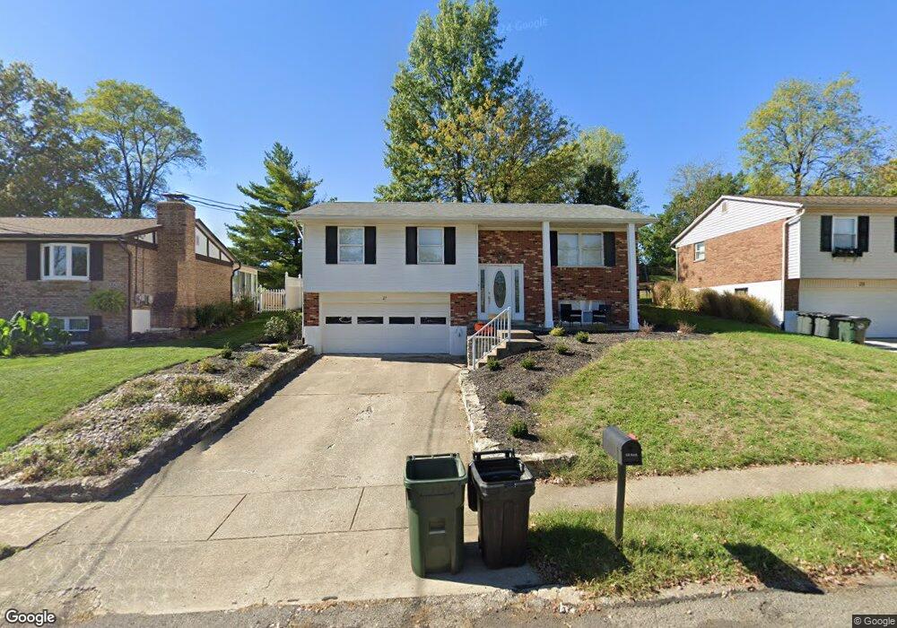
27 Stacy Ln Fort Thomas, KY 41075
Estimated Value: $359,000 - $391,000
3
Beds
2
Baths
1,560
Sq Ft
$238/Sq Ft
Est. Value
About This Home
This home is located at 27 Stacy Ln, Fort Thomas, KY 41075 and is currently estimated at $371,302, approximately $238 per square foot. 27 Stacy Ln is a home located in Campbell County with nearby schools including Highlands Middle School, Highlands High School, and St. Catherine of Siena School.
Ownership History
Date
Name
Owned For
Owner Type
Purchase Details
Closed on
Dec 6, 2023
Sold by
Craft David Alan and Craft Deborah
Bought by
Edgar Laura and Edgar Matthew
Current Estimated Value
Home Financials for this Owner
Home Financials are based on the most recent Mortgage that was taken out on this home.
Original Mortgage
$304,000
Outstanding Balance
$298,492
Interest Rate
7.79%
Mortgage Type
New Conventional
Estimated Equity
$72,810
Purchase Details
Closed on
Mar 11, 2010
Sold by
Craft Russell L and Craft Joan
Bought by
Craft David Alan
Home Financials for this Owner
Home Financials are based on the most recent Mortgage that was taken out on this home.
Original Mortgage
$80,000
Interest Rate
4.97%
Mortgage Type
New Conventional
Create a Home Valuation Report for This Property
The Home Valuation Report is an in-depth analysis detailing your home's value as well as a comparison with similar homes in the area
Home Values in the Area
Average Home Value in this Area
Purchase History
| Date | Buyer | Sale Price | Title Company |
|---|---|---|---|
| Edgar Laura | $320,000 | American Homeland Title | |
| Edgar Laura | $320,000 | American Homeland Title | |
| Craft David Alan | -- | None Available |
Source: Public Records
Mortgage History
| Date | Status | Borrower | Loan Amount |
|---|---|---|---|
| Open | Edgar Laura | $304,000 | |
| Closed | Edgar Laura | $304,000 | |
| Previous Owner | Craft David Alan | $80,000 |
Source: Public Records
Tax History
| Year | Tax Paid | Tax Assessment Tax Assessment Total Assessment is a certain percentage of the fair market value that is determined by local assessors to be the total taxable value of land and additions on the property. | Land | Improvement |
|---|---|---|---|---|
| 2025 | $1,232 | $320,000 | $45,000 | $275,000 |
| 2024 | $1,232 | $320,000 | $45,000 | $275,000 |
| 2023 | $1,284 | $325,000 | $45,000 | $280,000 |
| 2022 | $1,360 | $325,000 | $45,000 | $280,000 |
| 2021 | $724 | $160,000 | $40,000 | $120,000 |
| 2020 | $737 | $160,000 | $40,000 | $120,000 |
| 2019 | $743 | $160,000 | $40,000 | $120,000 |
| 2018 | $733 | $160,000 | $40,000 | $120,000 |
| 2017 | $662 | $142,100 | $40,000 | $102,100 |
| 2016 | $630 | $142,100 | $0 | $0 |
| 2015 | $640 | $142,100 | $0 | $0 |
| 2014 | $627 | $142,100 | $0 | $0 |
Source: Public Records
Map
Nearby Homes
- 57 E Kimberly Dr
- 42 E Kimberly Dr
- 31 Broadview Place
- 23 Beechwood Place
- 1859 Riverpointe Ct Unit 5
- 535 Riverpointe Dr Unit 4
- 814 Rossford Run
- 17 Harrison Ave
- 319 Rossford Ave
- 315 Rossford Ave
- 718 Belle Ridge Loop Unit 14
- 714 Belle Ridge Loop Unit 13
- 1226 5th Ave
- 706 Belle Ridge Loop Unit 11
- 861 Belle Ridge Loop
- 868 Belle Ridge Loop
- 872 Belle Ridge Loop
- 880 Belle Ridge Loop
- 1210 4th Ave
- 1028 5th Ave
Your Personal Tour Guide
Ask me questions while you tour the home.