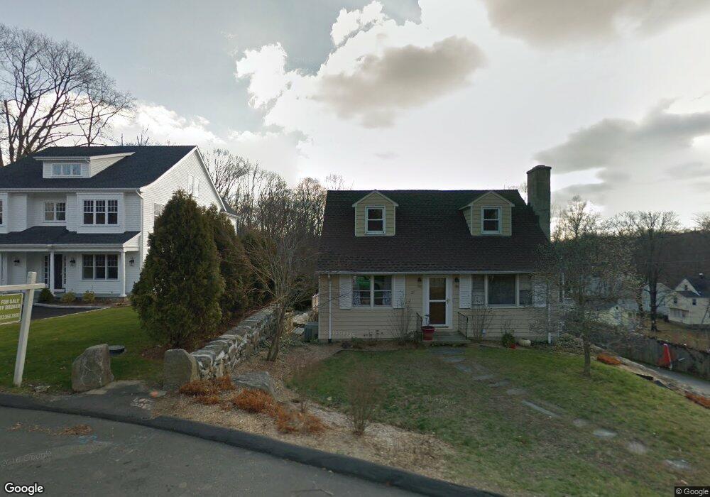
27 Strawberry Hill Rd New Canaan, CT 06840
Estimated Value: $924,000 - $1,113,000
3
Beds
2
Baths
1,248
Sq Ft
$830/Sq Ft
Est. Value
About This Home
This home is located at 27 Strawberry Hill Rd, New Canaan, CT 06840 and is currently estimated at $1,035,577, approximately $829 per square foot. 27 Strawberry Hill Rd is a home located in Fairfield County with nearby schools including East Elementary School, Saxe Middle School, and New Canaan High School.
Ownership History
Date
Name
Owned For
Owner Type
Purchase Details
Closed on
May 30, 1997
Sold by
Ryan Anthony F and Miller-Ryan Linda
Bought by
Miller-Smith Barbara G
Current Estimated Value
Purchase Details
Closed on
Jan 3, 1995
Sold by
Chappa Merlyn T
Bought by
Ryan Anthony F and Miller Ryan Linda
Home Financials for this Owner
Home Financials are based on the most recent Mortgage that was taken out on this home.
Original Mortgage
$160,000
Interest Rate
7.5%
Mortgage Type
Unknown
Create a Home Valuation Report for This Property
The Home Valuation Report is an in-depth analysis detailing your home's value as well as a comparison with similar homes in the area
Home Values in the Area
Average Home Value in this Area
Purchase History
| Date | Buyer | Sale Price | Title Company |
|---|---|---|---|
| Miller-Smith Barbara G | $250,000 | -- | |
| Ryan Anthony F | $200,000 | -- |
Source: Public Records
Mortgage History
| Date | Status | Borrower | Loan Amount |
|---|---|---|---|
| Previous Owner | Ryan Anthony F | $160,000 |
Source: Public Records
Tax History Compared to Growth
Tax History
| Year | Tax Paid | Tax Assessment Tax Assessment Total Assessment is a certain percentage of the fair market value that is determined by local assessors to be the total taxable value of land and additions on the property. | Land | Improvement |
|---|---|---|---|---|
| 2025 | $10,253 | $614,320 | $476,000 | $138,320 |
| 2024 | $9,915 | $614,320 | $476,000 | $138,320 |
| 2023 | $8,799 | $464,590 | $428,120 | $36,470 |
| 2022 | $8,535 | $464,590 | $428,120 | $36,470 |
| 2021 | $8,437 | $464,590 | $428,120 | $36,470 |
| 2020 | $8,437 | $464,590 | $428,120 | $36,470 |
| 2019 | $8,474 | $464,590 | $428,120 | $36,470 |
| 2018 | $7,796 | $442,750 | $396,410 | $46,340 |
| 2017 | $7,655 | $442,750 | $396,410 | $46,340 |
| 2016 | $7,481 | $442,750 | $396,410 | $46,340 |
| 2015 | $7,333 | $442,750 | $396,410 | $46,340 |
| 2014 | $7,129 | $442,750 | $396,410 | $46,340 |
Source: Public Records
Map
Nearby Homes
- 145 River St
- 61 Smith Ridge Rd
- 52 Garibaldi Ln
- 101 Parade Hill Rd
- 262 Brushy Ridge Rd
- 204 Parade Hill Rd
- 42 Forest St Unit A
- 240 Rosebrook Rd
- 60 East Ave
- 64 East Ave
- 15 Burtis Ave Unit Townhome D
- 15 Burtis Ave Unit West Penthouse B
- 15 Burtis Ave Unit East Penthouse C
- 15 Burtis Ave Unit Townhome A
- 15 Burtis Ave Unit East Plaza 203
- 180 Summer St
- 48 Brookwood Ln
- 122 Brookwood Ln
- 67 Carter St
- 197 Park St Unit 13
- 17 Strawberry Hill Rd
- 29 Strawberry Hill Rd
- 30 Strawberry Hill Rd
- 30 Strawberry Hill Rd Unit 1
- 147 River St
- 147-149 River St
- 153 River St
- 159 River St
- 34 Strawberry Hill Rd
- 139 River St
- 37 Strawberry Hill Rd
- 165 River St
- 144 Brushy Ridge Rd
- 10 Strawberry Hill Rd
- 10 Strawberry Hill Rd Unit 2
- 10 Strawberry Hill Rd Unit 1
- 31 Strawberry Hill Rd
- 7 Charles Place
- 149 River St Unit COTTA
- 149 River St