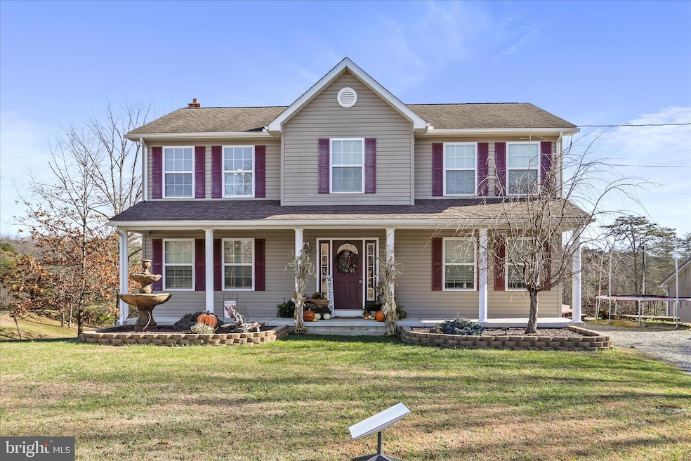

27 Towhee Hollow Springfield, WV 26763
Estimated payment $2,937/month
Highlights
- Popular Property
- Open Floorplan
- Wood Burning Stove
- View of Trees or Woods
- Deck
- Traditional Architecture
About This Home
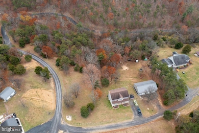
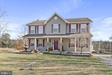
FORT ASHBY AREA HOME ON 5.66 ACRES WITH LARGE GARAGE & BEAUTIFUL VIEWS
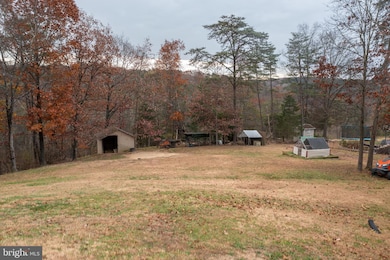
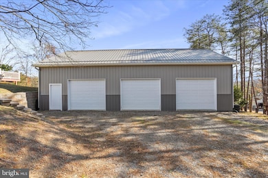
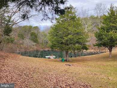
Welcome to 27 Towhee Hollow, a well-appointed property offering space, comfort, and a peaceful setting. Situated on 5.66 acres, this home features 4 bedrooms, 2.5 bathrooms, and plenty of room to enjoy both indoors and out. The main level includes a spacious family room with a propane fireplace, an eat-in kitchen, and a flexible room that can serve as a formal dining room or additional living space. A half bathroom with a laundry area adds convenience. Upstairs, you’ll find a spacious primary suite with a walk-in closet and attached full bathroom. Three additional bedrooms and another full bathroom complete the upper level. The unfinished basement provides great potential for future expansion or storage. Step outside to a deck overlooking the backyard and mountain views, perfect for relaxing or entertaining. The property also includes a large detached three-car garage with a walk-up attic—ideal for storage, hobbies, or workspace. With wooded trails for dirt bikes and the community pond and recreation area just around the corner, this home offers a great mix of privacy and outdoor enjoyment. Call today to schedule your showing—properties like this don’t come along often!
Listing Agent
(301) 268-7504 alittenmd@gmail.com Mountainside Home Realty License #WVB210300750 Listed on: 11/14/2025
Home Details
Home Type
- Single Family
Est. Annual Taxes
- $1,699
Year Built
- Built in 2009
Lot Details
- 5.66 Acre Lot
- Backs to Trees or Woods
- Property is zoned 101
HOA Fees
- $3 Monthly HOA Fees
Parking
- 3 Car Detached Garage
- Parking Storage or Cabinetry
- Front Facing Garage
- Driveway
Property Views
- Woods
- Mountain
Home Design
- Traditional Architecture
- Permanent Foundation
- Vinyl Siding
Interior Spaces
- 2,104 Sq Ft Home
- Property has 3 Levels
- Open Floorplan
- Fireplace
- Wood Burning Stove
- Dining Area
- Carpet
- Laundry on main level
- Attic
- Unfinished Basement
Kitchen
- Breakfast Area or Nook
- Eat-In Kitchen
- Kitchen Island
Bedrooms and Bathrooms
- 4 Bedrooms
- En-Suite Bathroom
- Walk-In Closet
Outdoor Features
- Deck
- Shed
- Outbuilding
- Porch
Utilities
- Forced Air Heating and Cooling System
- Heat Pump System
- Heating System Powered By Leased Propane
- Well
- Electric Water Heater
- On Site Septic
Community Details
- Greenwood Subdivision
Listing and Financial Details
- Assessor Parcel Number 04 32004900000000
Map
Home Values in the Area
Average Home Value in this Area
Tax History
| Year | Tax Paid | Tax Assessment Tax Assessment Total Assessment is a certain percentage of the fair market value that is determined by local assessors to be the total taxable value of land and additions on the property. | Land | Improvement |
|---|---|---|---|---|
| 2024 | $1,700 | $139,880 | $18,740 | $121,140 |
| 2023 | $1,670 | $135,860 | $18,740 | $117,120 |
| 2022 | $1,646 | $137,900 | $18,740 | $119,160 |
| 2021 | $1,646 | $137,900 | $18,740 | $119,160 |
| 2020 | $1,497 | $125,360 | $18,740 | $106,620 |
| 2019 | $1,497 | $125,360 | $18,740 | $106,620 |
| 2018 | $1,497 | $125,360 | $18,740 | $106,620 |
| 2017 | $1,423 | $119,180 | $18,740 | $100,440 |
| 2016 | $1,423 | $119,160 | $18,720 | $100,440 |
| 2015 | $1,423 | $119,220 | $18,720 | $100,500 |
| 2014 | $1,424 | $119,240 | $18,720 | $100,520 |
Property History
| Date | Event | Price | List to Sale | Price per Sq Ft |
|---|---|---|---|---|
| 11/14/2025 11/14/25 | For Sale | $529,900 | -- | $252 / Sq Ft |
Purchase History
| Date | Type | Sale Price | Title Company |
|---|---|---|---|
| Interfamily Deed Transfer | -- | Solidifi Title | |
| Deed | $26,000 | -- |
Mortgage History
| Date | Status | Loan Amount | Loan Type |
|---|---|---|---|
| Open | $170,000 | New Conventional |
Source: Bright MLS
MLS Number: WVMI2003820
APN: 04-32-00490000
Disclaimer: Certain information contained herein is derived from information provided by parties other than Homes.com. All information provided is deemed reliable, but is not guaranteed to be accurate and should be independently verified.
![]() The data relating to real estate for sale on this website appears in part through the BRIGHT Internet Data Exchange program, a voluntary cooperative exchange of property listing data between licensed real estate brokerage firms, and is provided by BRIGHT through a licensing agreement.
The data relating to real estate for sale on this website appears in part through the BRIGHT Internet Data Exchange program, a voluntary cooperative exchange of property listing data between licensed real estate brokerage firms, and is provided by BRIGHT through a licensing agreement.
Listing information is from various brokers who participate in the Bright MLS IDX program and not all listings may be visible on the site.
The property information being provided on or through the website is for the personal, non-commercial use of consumers and such information may not be used for any purpose other than to identify prospective properties consumers may be interested in purchasing.
Some properties which appear for sale on the website may no longer be available because they are for instance, under contract, sold or are no longer being offered for sale.
Property information displayed is deemed reliable but is not guaranteed.
Copyright 2025 Bright MLS, Inc.
- 144 Mark St
- 99 E Creek Run Loop
- 135 Mark St
- 10912 Frankfort Hwy
- 86 Fort Ashby Cemetery Rd
- Lot 45 Ashby Crest Estates
- 22 Meadow Way
- 79 Leon Dr
- Lot 44 Ashby Crest Estates
- Lot 27 Ashby Crest Estates
- 52 S Easy St
- 13531 Frankfort Hwy
- 2180 Old Smith Farm Rd
- 2525 Plum Run Rd
- 3970 Patterson Creek Village Pike
- 152 Acres Plum Run Rd
- 4019 Patterson Creek Village Pike
- Lot 16 Colonial Heights Dr
- 102 Bluffs Ridge Rd
- 13214 Oldtown Rd SE
- 215 E Elder St
- 328 Virginia Ave Unit A
- 307 Arch St
- 113 Grand Ave
- 108 Springdale St
- 36 Hawthorne Ave
- 759 Maryland Ave Unit 1
- 201 Spring St Unit Lower
- 201 Spring St Unit Upper
- 124-126 Greene St Unit 124 Basement
- 4 Altamont Terrace Unit 5
- 229 Baltimore Ave
- 328 Fayette St Unit 10
- 225 Charles St Unit A
- 12500 Old Willow Brook Rd SE
- 529 N Centre St Unit Rear
- 740 N Mechanic St
- 623 Columbia Ave Unit B
- 623 Columbia Ave Unit C
- 600 Franklin St
