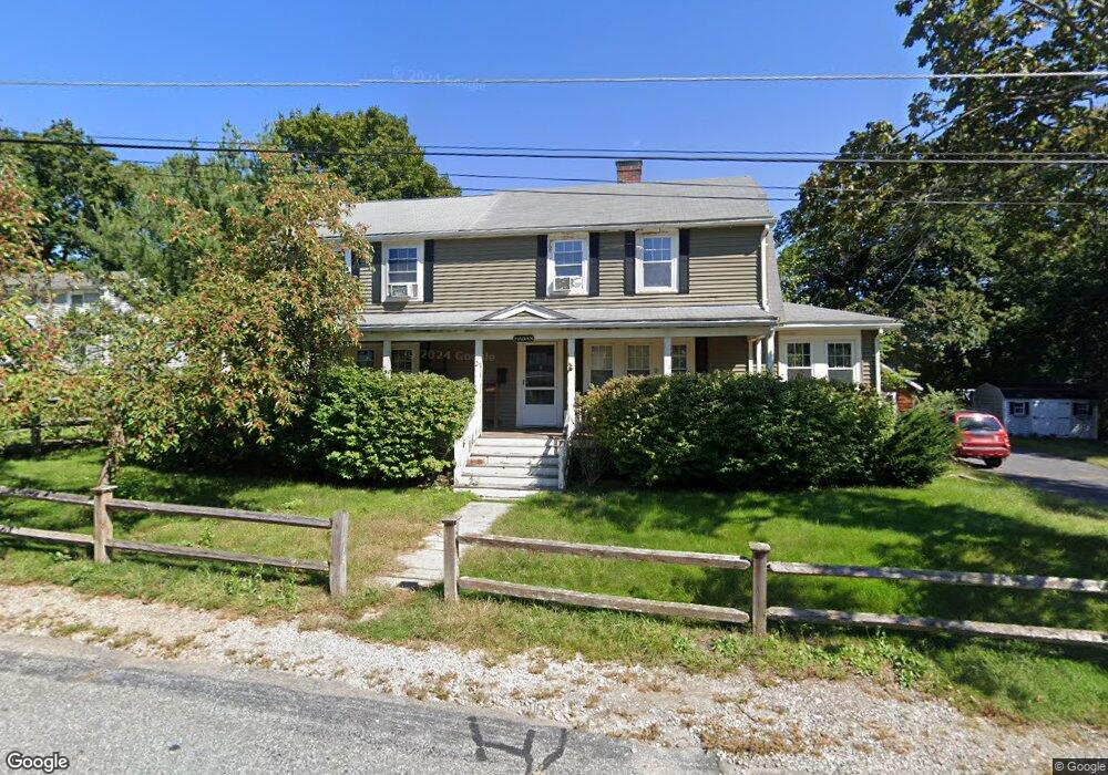
27 Vinald Rd Medfield, MA 02052
Estimated Value: $747,000 - $872,932
4
Beds
3
Baths
2,608
Sq Ft
$318/Sq Ft
Est. Value
About This Home
This home is located at 27 Vinald Rd, Medfield, MA 02052 and is currently estimated at $829,483, approximately $318 per square foot. 27 Vinald Rd is a home located in Norfolk County with nearby schools including Memorial School, Ralph Wheelock School, and Dale Street School.
Ownership History
Date
Name
Owned For
Owner Type
Purchase Details
Closed on
Feb 3, 2014
Sold by
Hagan Samantha R and Hagan Eric J
Bought by
Hagan Samantha R
Current Estimated Value
Purchase Details
Closed on
Mar 29, 1995
Sold by
Horan Richard F and Horan Nancy T
Bought by
Hagan Eric J and Hagan Samatha R
Purchase Details
Closed on
Mar 2, 1989
Sold by
Constatine Steven
Bought by
Horan Richard F
Create a Home Valuation Report for This Property
The Home Valuation Report is an in-depth analysis detailing your home's value as well as a comparison with similar homes in the area
Home Values in the Area
Average Home Value in this Area
Purchase History
| Date | Buyer | Sale Price | Title Company |
|---|---|---|---|
| Hagan Samantha R | -- | -- | |
| Hagan Samantha R | -- | -- | |
| Hagan Eric J | $163,000 | -- | |
| Hagan Eric J | $163,000 | -- | |
| Horan Richard F | $200,000 | -- | |
| Horan Richard F | $200,000 | -- |
Source: Public Records
Mortgage History
| Date | Status | Borrower | Loan Amount |
|---|---|---|---|
| Previous Owner | Horan Richard F | $220,000 | |
| Previous Owner | Horan Richard F | $154,000 |
Source: Public Records
Tax History
| Year | Tax Paid | Tax Assessment Tax Assessment Total Assessment is a certain percentage of the fair market value that is determined by local assessors to be the total taxable value of land and additions on the property. | Land | Improvement |
|---|---|---|---|---|
| 2025 | $9,735 | $705,400 | $359,900 | $345,500 |
| 2024 | $9,554 | $652,600 | $330,800 | $321,800 |
| 2023 | $9,344 | $605,600 | $314,300 | $291,300 |
| 2022 | $8,670 | $497,700 | $297,700 | $200,000 |
| 2021 | $8,486 | $477,800 | $289,500 | $188,300 |
| 2020 | $8,346 | $468,100 | $286,100 | $182,000 |
| 2019 | $8,283 | $463,500 | $277,900 | $185,600 |
| 2018 | $7,713 | $452,900 | $260,700 | $192,200 |
| 2017 | $7,548 | $446,900 | $254,700 | $192,200 |
| 2016 | $7,459 | $445,300 | $253,100 | $192,200 |
| 2015 | $7,141 | $445,200 | $246,700 | $198,500 |
| 2014 | $6,527 | $404,900 | $206,400 | $198,500 |
Source: Public Records
Map
Nearby Homes
- 13 Frairy St Unit 13
- 29 Vinald Rd
- 29 Vinald Rd Unit 1
- 24 Vinald Rd
- 30 Vinald Rd
- 34 Vinald Rd
- 15 Frairy St
- 18 Vinald Rd
- 12 Vinald Rd
- 14 Vinald Rd
- 12 Vinald Rd
- 14 Vinald Rd Unit 14
- 38 Vinald Rd
- 39 Vinald Rd
- 4 Vinald Rd
- 4 Vinald Rd
- 10 Mitchell St
- 29 Frairy St
- 29 Frairy St Unit 1
- 29 Frairy St Unit 1 or 2
Your Personal Tour Guide
Ask me questions while you tour the home.