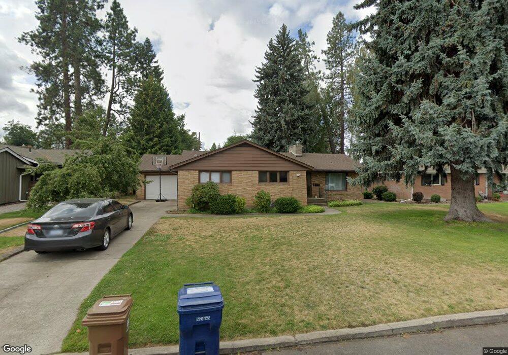
27 W 39th Ave Spokane, WA 99203
Comstock NeighborhoodEstimated Value: $497,000 - $603,000
2
Beds
2
Baths
1,436
Sq Ft
$392/Sq Ft
Est. Value
About This Home
This home is located at 27 W 39th Ave, Spokane, WA 99203 and is currently estimated at $562,908, approximately $391 per square foot. 27 W 39th Ave is a home located in Spokane County with nearby schools including Jefferson Elementary School, Sacajawea Middle School, and Lewis & Clark High School.
Ownership History
Date
Name
Owned For
Owner Type
Purchase Details
Closed on
Nov 30, 2011
Sold by
Mckerricher Boyd Patricia K
Bought by
Willow Properties Llc
Current Estimated Value
Purchase Details
Closed on
Dec 15, 2004
Sold by
C 1031 Properties Inc
Bought by
Mckerricher Patricia
Purchase Details
Closed on
Jun 25, 2004
Sold by
Bolkan Dorothy J
Bought by
C 1031 Properties Inc
Create a Home Valuation Report for This Property
The Home Valuation Report is an in-depth analysis detailing your home's value as well as a comparison with similar homes in the area
Home Values in the Area
Average Home Value in this Area
Purchase History
| Date | Buyer | Sale Price | Title Company |
|---|---|---|---|
| Willow Properties Llc | -- | None Available | |
| Mckerricher Patricia | -- | Pacific Nw Title | |
| C 1031 Properties Inc | $142,500 | Pacific Nw Title |
Source: Public Records
Tax History Compared to Growth
Tax History
| Year | Tax Paid | Tax Assessment Tax Assessment Total Assessment is a certain percentage of the fair market value that is determined by local assessors to be the total taxable value of land and additions on the property. | Land | Improvement |
|---|---|---|---|---|
| 2025 | $5,082 | $526,800 | $125,000 | $401,800 |
| 2024 | $5,082 | $512,500 | $100,000 | $412,500 |
| 2023 | $5,398 | $517,200 | $90,000 | $427,200 |
| 2022 | $4,774 | $552,400 | $81,000 | $471,400 |
| 2021 | $4,258 | $358,200 | $64,800 | $293,400 |
| 2020 | $4,089 | $331,400 | $64,800 | $266,600 |
| 2019 | $3,358 | $281,000 | $54,000 | $227,000 |
| 2018 | $3,648 | $262,300 | $50,000 | $212,300 |
| 2017 | $3,294 | $241,200 | $45,000 | $196,200 |
| 2016 | $2,957 | $211,800 | $45,000 | $166,800 |
| 2015 | $2,841 | $199,100 | $45,000 | $154,100 |
| 2014 | -- | $188,100 | $43,000 | $145,100 |
| 2013 | -- | $0 | $0 | $0 |
Source: Public Records
Map
Nearby Homes
- 17 W 31st Ave
- 504 E 41st Ave
- 3534 S Grand Blvd
- 3121 S Manito Blvd
- 3334 S Manito Blvd
- 3338 S Manito Blvd
- 3022 S Manito Blvd
- 3419 S Saxon Ct
- 3415 S Grand Blvd
- 3018 S Manito Blvd
- 19 W 29th Ave
- 2923 S Manito Blvd
- 106 E 29th Ave
- 803 E 39th Ave
- 3433 S High Dr
- 807 E 40th Ave
- 403 W 29th Ave Unit 403
- 704 E High Dr
- 904 E 40th Ave
- 208 W 28th Ave