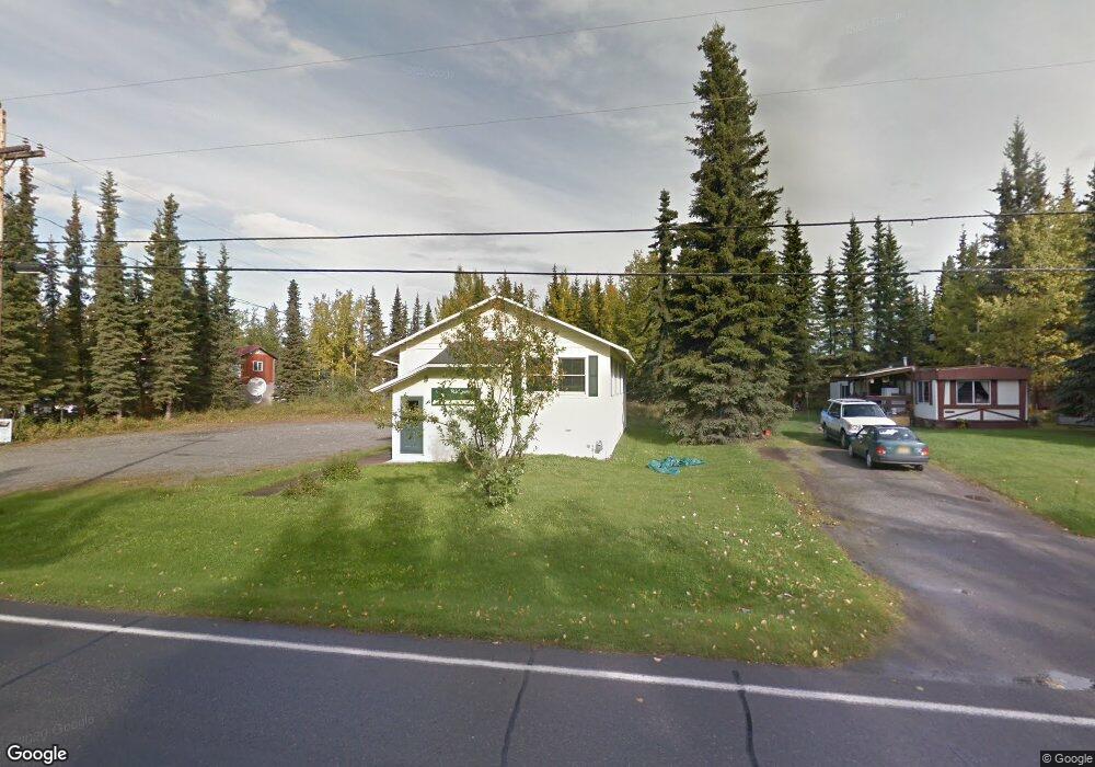
270 Banner Ln Soldotna, AK 99669
Estimated Value: $157,000 - $288,000
3
Beds
1
Bath
960
Sq Ft
$250/Sq Ft
Est. Value
About This Home
This home is located at 270 Banner Ln, Soldotna, AK 99669 and is currently estimated at $239,691, approximately $249 per square foot. 270 Banner Ln is a home located in Kenai Peninsula Borough with nearby schools including Redoubt Elementary School, Skyview Middle School, and Soldotna High School.
Ownership History
Date
Name
Owned For
Owner Type
Purchase Details
Closed on
Nov 17, 2003
Sold by
United States Of America
Bought by
Medley Alexander H
Current Estimated Value
Purchase Details
Closed on
Mar 18, 2003
Sold by
Dawson Norma J
Bought by
Rural Development
Purchase Details
Closed on
Mar 13, 2002
Sold by
Alt Dean A and Alt Wendy A
Bought by
Dawson Norma J
Home Financials for this Owner
Home Financials are based on the most recent Mortgage that was taken out on this home.
Original Mortgage
$19,100
Interest Rate
6.99%
Create a Home Valuation Report for This Property
The Home Valuation Report is an in-depth analysis detailing your home's value as well as a comparison with similar homes in the area
Home Values in the Area
Average Home Value in this Area
Purchase History
| Date | Buyer | Sale Price | Title Company |
|---|---|---|---|
| Medley Alexander H | -- | -- | |
| Rural Development | $83,950 | -- | |
| Dawson Norma J | -- | First American Title |
Source: Public Records
Mortgage History
| Date | Status | Borrower | Loan Amount |
|---|---|---|---|
| Previous Owner | Dawson Norma J | $19,100 | |
| Closed | Dawson Norma J | $76,400 |
Source: Public Records
Tax History Compared to Growth
Tax History
| Year | Tax Paid | Tax Assessment Tax Assessment Total Assessment is a certain percentage of the fair market value that is determined by local assessors to be the total taxable value of land and additions on the property. | Land | Improvement |
|---|---|---|---|---|
| 2025 | $1,460 | $195,500 | $42,600 | $152,900 |
| 2024 | $730 | $182,000 | $41,600 | $140,400 |
| 2023 | $1,328 | $165,600 | $37,800 | $127,800 |
| 2022 | $1,273 | $162,000 | $36,000 | $126,000 |
| 2021 | $1,135 | $148,100 | $26,700 | $121,400 |
| 2020 | $1,095 | $135,900 | $26,700 | $109,200 |
| 2019 | $1,123 | $139,300 | $24,300 | $115,000 |
| 2018 | $1,135 | $140,800 | $24,300 | $116,500 |
| 2017 | $1,023 | $134,400 | $24,300 | $110,100 |
| 2016 | $998 | $129,100 | $24,300 | $104,800 |
| 2015 | $994 | $126,400 | $24,300 | $102,100 |
| 2014 | $994 | $124,900 | $24,300 | $100,600 |
Source: Public Records
Map
Nearby Homes
- 327 Knight Dr
- 35839 Irons Ave
- 35841 Irons Ave
- 35870 Glory St
- 35868 Everwell Place
- 35856 Everwell Place
- 35840 Everwell Place
- 265 Charity Cir
- 36050 Irons Ave
- L42 N Aspen Dr
- 235 N Aspen Dr
- 000 Ridgewood Dr
- 366 Diane Ln
- 386 W Corral Ave
- 169 N Brentwood St
- 36060 Greenridge St
- L1 Kenai Spur Hwy
- 256 Upper Rosian Dr
- 253 Upper Rosian Dr
- 36420 Northern Lights Blvd