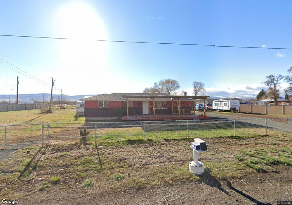
270 Coburn Loop Rd White Swan, WA 98952
Estimated Value: $310,582 - $357,000
4
Beds
2
Baths
1,536
Sq Ft
$213/Sq Ft
Est. Value
About This Home
This home is located at 270 Coburn Loop Rd, White Swan, WA 98952 and is currently estimated at $326,646, approximately $212 per square foot. 270 Coburn Loop Rd is a home located in Yakima County with nearby schools including Harrah Elementary School, Mount Adams Middle School, and White Swan High School.
Ownership History
Date
Name
Owned For
Owner Type
Purchase Details
Closed on
Sep 12, 2017
Sold by
Philip Darlene
Bought by
Stanton Dacie R
Current Estimated Value
Purchase Details
Closed on
Oct 1, 2013
Sold by
Confederated Tribes & Bands Of The Yakim
Bought by
Phillips Darlene
Purchase Details
Closed on
Jul 9, 2008
Sold by
Bobb Robert and Martinez Delores
Bought by
Confederated Tribes & Bands Of The Yakam
Create a Home Valuation Report for This Property
The Home Valuation Report is an in-depth analysis detailing your home's value as well as a comparison with similar homes in the area
Home Values in the Area
Average Home Value in this Area
Purchase History
| Date | Buyer | Sale Price | Title Company |
|---|---|---|---|
| Stanton Dacie R | -- | None Available | |
| Phillips Darlene | -- | Valley Title Guarantee | |
| Confederated Tribes & Bands Of The Yakam | $152,229 | None Available |
Source: Public Records
Tax History Compared to Growth
Tax History
| Year | Tax Paid | Tax Assessment Tax Assessment Total Assessment is a certain percentage of the fair market value that is determined by local assessors to be the total taxable value of land and additions on the property. | Land | Improvement |
|---|---|---|---|---|
| 2025 | $4,406 | $261,800 | $74,100 | $187,700 |
| 2023 | $2,207 | $126,800 | $25,400 | $101,400 |
| 2022 | $1,590 | $180,100 | $32,500 | $147,600 |
| 2021 | $5,544 | $180,300 | $25,000 | $155,300 |
| 2019 | $1,398 | $148,400 | $25,000 | $123,400 |
| 2018 | $1,053 | $108,000 | $25,000 | $83,000 |
| 2017 | $1,377 | $99,300 | $25,000 | $74,300 |
| 2016 | $238 | $96,800 | $24,900 | $71,900 |
| 2015 | $238 | $100,200 | $24,900 | $75,300 |
| 2014 | $238 | $80,700 | $24,900 | $55,800 |
| 2013 | $238 | $80,700 | $24,900 | $55,800 |
Source: Public Records
Map
Nearby Homes
- 331 1st St
- KNA 1st St
- 400 First St
- 401 Curtis St
- 403 Curtis St
- 41 Curtis St
- 31 Curtis St
- NKA Louden Rd
- 0 Louden Rd
- 1081 Tecumseh Rd
- 3500 Island Rd Unit N & S
- 3500 Island Rd Unit South
- 3500 Island Rd Unit North Parcel
- 3500 Island Rd Unit North
- 11334 Pumphouse Rd
- 41 Washington St
- NKA Fort Rd
- 14530 W Rutherford Rd
- 754 Kings Ln
- 14530 Rutherford Rd
- 230 Coburn Loop Rd
- 261 Coburn Loop Rd
- 320 Coburn Loop Rd
- 322 Coburn Loop Rd
- 340 Coburn Loop Rd
- 181 Coburn Loop Rd
- 321 Coburn Loop Rd
- 451 W White Swan Rd
- 341 Coburn Loop Rd
- 380 Coburn Loop Rd
- 80 Coburn Loop Rd
- 361 Coburn Loop Rd
- 50 Coburn Loop Rd
- 10 Coburn Loop Rd
- 421 Coburn Loop Rd
- 471 Coburn Loop Rd
- 503 Coburn Loop Rd
- 201 & 203 2nd St
- 230 2nd St
- 250 2nd St