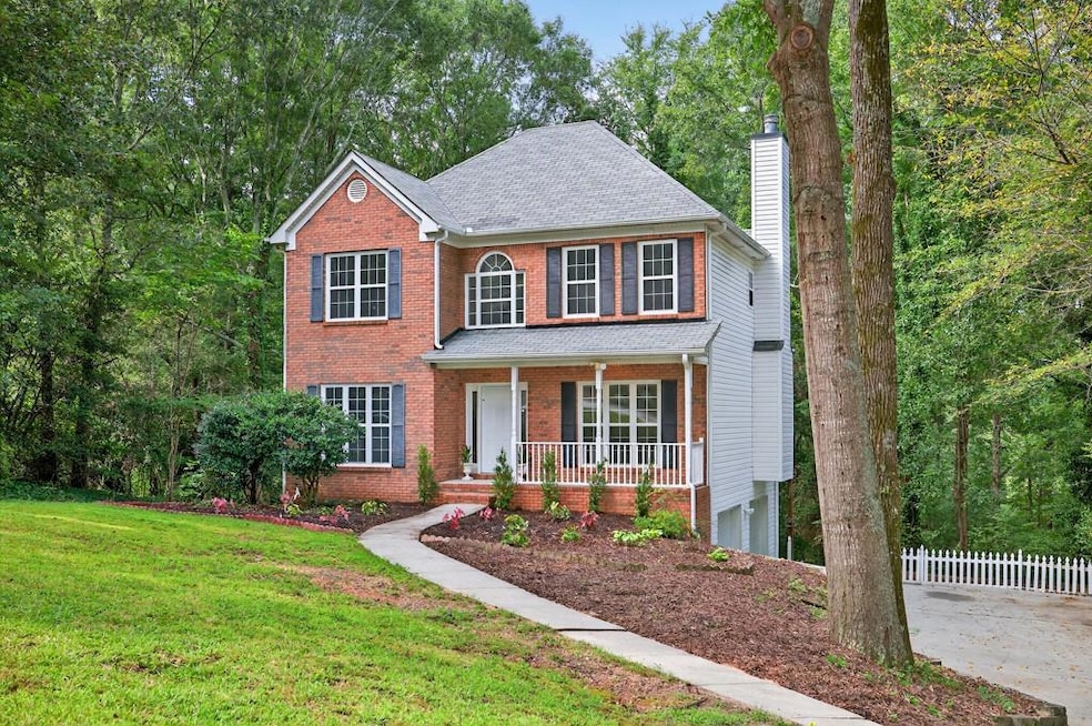


270 Hambridge Ct Unit 1 Lawrenceville, GA 30043
Estimated payment $2,587/month
Highlights
- View of Trees or Woods
- 1.53 Acre Lot
- Deck
- Taylor Elementary School Rated A
- Dining Room Seats More Than Twelve
- Vaulted Ceiling
About This Home
Move-in ready two-story on a private 1.53-acre wooded lot in Hambridge Court. Fresh paint, new flooring, and stylish lighting throughout. Kitchen features quartz counters, stainless steel appliances, and updated finishes. Upstairs, the vaulted primary suite includes a spacious bath with double vanity, garden tub, tiled shower, and XL walk-in closet. Two secondary bedrooms share an updated hall bath. Finished flex room with closet on the lower level makes a perfect office, gym, media room, or 4th bedroom. Enjoy wooded views from the large deck, plus a two-car garage, partial finished basement, newer roof, serviced HVAC (2025), and Collins Hill schools. Convenient to I-85, Hwy 316, and Mall of Georgia.
Home Details
Home Type
- Single Family
Est. Annual Taxes
- $4,158
Year Built
- Built in 1998
Lot Details
- 1.53 Acre Lot
- Private Yard
- Back and Front Yard
Parking
- 2 Car Garage
- Side Facing Garage
- Garage Door Opener
- Drive Under Main Level
- Driveway
- On-Street Parking
Home Design
- Traditional Architecture
- Slab Foundation
- Shingle Roof
- Composition Roof
- Brick Front
- Concrete Perimeter Foundation
Interior Spaces
- 3-Story Property
- Tray Ceiling
- Vaulted Ceiling
- Ceiling Fan
- Raised Hearth
- Fireplace With Gas Starter
- Brick Fireplace
- Double Pane Windows
- Insulated Windows
- Two Story Entrance Foyer
- Family Room with Fireplace
- Dining Room Seats More Than Twelve
- Formal Dining Room
- Views of Woods
- Fire and Smoke Detector
Kitchen
- Open to Family Room
- Eat-In Kitchen
- Gas Cooktop
- Range Hood
- Dishwasher
- Kitchen Island
- Stone Countertops
- White Kitchen Cabinets
- Disposal
Flooring
- Carpet
- Tile
- Luxury Vinyl Tile
Bedrooms and Bathrooms
- Vaulted Bathroom Ceilings
- Dual Vanity Sinks in Primary Bathroom
- Whirlpool Bathtub
- Separate Shower in Primary Bathroom
Laundry
- Laundry Room
- Sink Near Laundry
Finished Basement
- Walk-Out Basement
- Partial Basement
- Garage Access
- Exterior Basement Entry
- Laundry in Basement
Outdoor Features
- Deck
- Covered Patio or Porch
Location
- Property is near schools
- Property is near shops
Schools
- Taylor - Gwinnett Elementary School
- Creekland - Gwinnett Middle School
- Collins Hill High School
Utilities
- Forced Air Heating and Cooling System
- Heating System Uses Natural Gas
- Underground Utilities
- Gas Water Heater
- Septic Tank
- High Speed Internet
- Phone Available
- Cable TV Available
Listing and Financial Details
- Legal Lot and Block 8 / A
- Assessor Parcel Number R7068 112
Community Details
Overview
- Hambridge Court Subdivision
Recreation
- Trails
Map
Home Values in the Area
Average Home Value in this Area
Tax History
| Year | Tax Paid | Tax Assessment Tax Assessment Total Assessment is a certain percentage of the fair market value that is determined by local assessors to be the total taxable value of land and additions on the property. | Land | Improvement |
|---|---|---|---|---|
| 2024 | $4,158 | $148,800 | $33,160 | $115,640 |
| 2023 | $4,158 | $148,800 | $33,160 | $115,640 |
| 2022 | $3,829 | $134,560 | $33,160 | $101,400 |
| 2021 | $2,915 | $88,200 | $18,640 | $69,560 |
| 2020 | $2,934 | $88,200 | $18,640 | $69,560 |
| 2019 | $2,854 | $88,200 | $18,640 | $69,560 |
| 2018 | $2,856 | $88,200 | $18,640 | $69,560 |
| 2016 | $2,499 | $70,800 | $17,000 | $53,800 |
| 2015 | $2,527 | $70,800 | $17,000 | $53,800 |
| 2014 | -- | $65,560 | $20,040 | $45,520 |
Property History
| Date | Event | Price | List to Sale | Price per Sq Ft |
|---|---|---|---|---|
| 09/24/2025 09/24/25 | Price Changed | $425,000 | -5.6% | $182 / Sq Ft |
| 08/14/2025 08/14/25 | For Sale | $450,000 | -- | $193 / Sq Ft |
Purchase History
| Date | Type | Sale Price | Title Company |
|---|---|---|---|
| Deed | $200,000 | -- | |
| Deed | -- | -- |
Mortgage History
| Date | Status | Loan Amount | Loan Type |
|---|---|---|---|
| Open | $196,910 | FHA |
Source: First Multiple Listing Service (FMLS)
MLS Number: 7632133
APN: 7-068-112
Disclaimer: Certain information contained herein is derived from information provided by parties other than Homes.com. All information provided is deemed reliable, but is not guaranteed to be accurate and should be independently verified.
![]() Listings identified with the FMLS IDX logo come from FMLS and are held by brokerage firms other than the owner of this website. The listing brokerage is identified in any listing details. Information is deemed reliable but is not guaranteed. If you believe any FMLS listing contains material that infringes your copyrighted work please visit www.fmls.com/dmca to review our DMCA policy and learn how to submit a takedown request. © 2025 First Multiple Listing Service, Inc.
Listings identified with the FMLS IDX logo come from FMLS and are held by brokerage firms other than the owner of this website. The listing brokerage is identified in any listing details. Information is deemed reliable but is not guaranteed. If you believe any FMLS listing contains material that infringes your copyrighted work please visit www.fmls.com/dmca to review our DMCA policy and learn how to submit a takedown request. © 2025 First Multiple Listing Service, Inc.
- 2680 Whistler Way NE
- 2244 Whistler Way NE
- 2678 Whistler Way NE
- 121 Chantilly Ln
- 438 Russell Rd
- 1660 Cheshire Ct NW
- 1848 Stonebrook Way
- 582 Inwood Trail Unit 1
- 270 Allatoona Rd
- 1300 Ashlyn Ct
- 1340 Ashlyn Ct
- 1339 Ashlyn Ct
- 1190 Ashlyn Ct
- 25 Karen Camille Dr NW
- 1831 Green Oak Cir
- 675 Ambur Cove Way NW
- 1500 Wellston Dr
- 1560 Wellston Dr
- 328 Deerwood Dr
- 812 Brighton Dr NW
