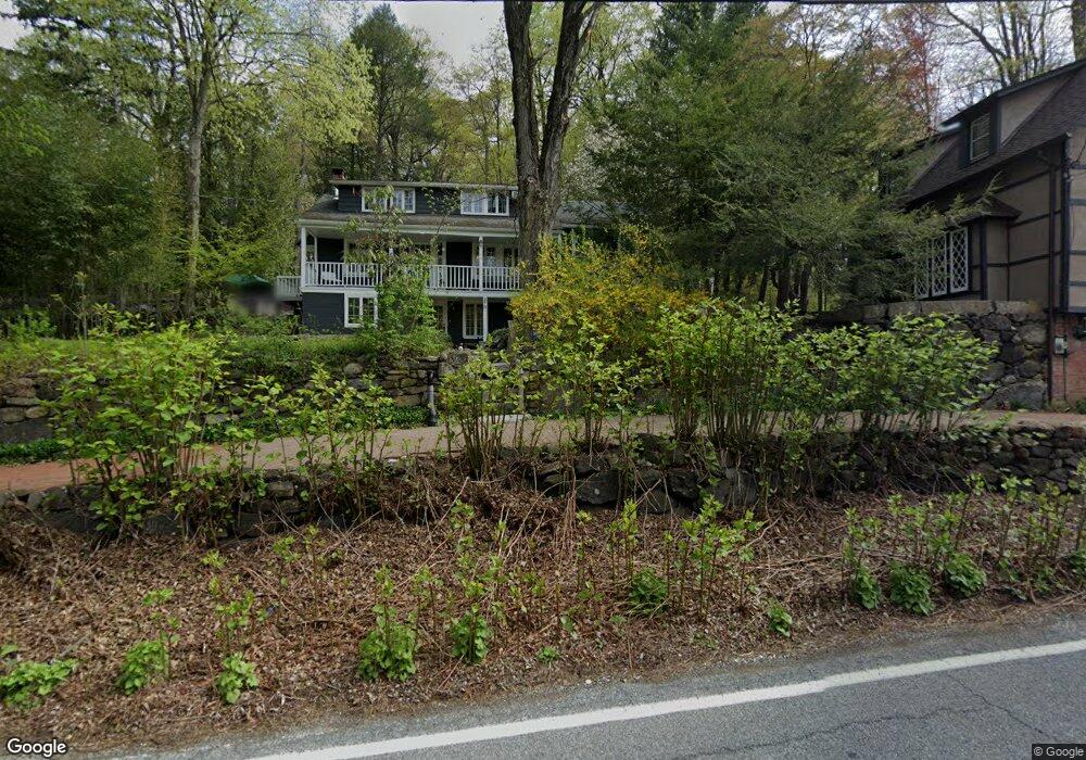
270 Mount Airy Rd W Croton On Hudson, NY 10520
Estimated Value: $905,133 - $1,083,000
4
Beds
3
Baths
2,462
Sq Ft
$407/Sq Ft
Est. Value
About This Home
This home is located at 270 Mount Airy Rd W, Croton On Hudson, NY 10520 and is currently estimated at $1,003,033, approximately $407 per square foot. 270 Mount Airy Rd W is a home located in Westchester County with nearby schools including Carrie E Tompkins School, Pierre Van Cortlandt Middle School, and Ohr Hameir Seminary - Tifereth Israel High School.
Ownership History
Date
Name
Owned For
Owner Type
Purchase Details
Closed on
Aug 30, 2016
Sold by
Bussiere Deborah and Bussiere Benoit
Bought by
Beckwith Laura K and Devoe Yates Iii Walter
Current Estimated Value
Purchase Details
Closed on
Mar 1, 1999
Sold by
Kaiser Robert H and Kaiser Ruth
Bought by
Bussiere Benoit and Bussiere Deborah
Home Financials for this Owner
Home Financials are based on the most recent Mortgage that was taken out on this home.
Original Mortgage
$303,750
Interest Rate
8.21%
Mortgage Type
Purchase Money Mortgage
Create a Home Valuation Report for This Property
The Home Valuation Report is an in-depth analysis detailing your home's value as well as a comparison with similar homes in the area
Home Values in the Area
Average Home Value in this Area
Purchase History
| Date | Buyer | Sale Price | Title Company |
|---|---|---|---|
| Beckwith Laura K | $779,000 | Stewart Title Insurance | |
| Bussiere Benoit | $337,500 | First American Title Ins Co |
Source: Public Records
Mortgage History
| Date | Status | Borrower | Loan Amount |
|---|---|---|---|
| Previous Owner | Bussiere Benoit | $303,750 |
Source: Public Records
Tax History Compared to Growth
Tax History
| Year | Tax Paid | Tax Assessment Tax Assessment Total Assessment is a certain percentage of the fair market value that is determined by local assessors to be the total taxable value of land and additions on the property. | Land | Improvement |
|---|---|---|---|---|
| 2024 | $15,852 | $8,450 | $1,450 | $7,000 |
| 2023 | $15,559 | $8,450 | $1,450 | $7,000 |
| 2022 | $15,201 | $8,450 | $1,450 | $7,000 |
| 2021 | $15,056 | $8,450 | $1,450 | $7,000 |
| 2020 | $14,850 | $8,450 | $1,450 | $7,000 |
| 2019 | $14,672 | $8,450 | $1,450 | $7,000 |
| 2018 | $14,382 | $8,450 | $1,450 | $7,000 |
| 2017 | $4,162 | $8,450 | $1,450 | $7,000 |
| 2016 | $14,063 | $8,450 | $1,450 | $7,000 |
| 2015 | -- | $8,450 | $1,450 | $7,000 |
| 2014 | -- | $8,450 | $1,450 | $7,000 |
| 2013 | -- | $8,450 | $1,450 | $7,000 |
Source: Public Records
Map
Nearby Homes
- 10 Wood Dale Ave
- 196 Furnace Dock Rd
- 14 Amalfi Dr
- 16 Scenic Dr Unit X
- 16 Scenic Dr Unit S
- 16 Scenic Dr Unit N
- 16 Scenic Dr Unit M
- 15 Scenic Dr Unit D
- 15 Scenic Dr Unit K
- 215 Hessian Hills Rd
- 270 Furnace Dock Rd
- 14 Scenic Dr Unit 14T
- 23 Chester Ct
- 13 Scenic Dr Unit M
- 13 Scenic Dr Unit D
- 21 Glengary Rd
- 12 Scenic Dr Unit K
- 65 Furnace Brook Dr
- 34 Mount Airy Rd E
- 5 Robin Ln
- 250 Mount Airy Rd W
- 1 Hale Hollow Rd Unit 3
- 1 Hale Hollow Rd Unit 5
- 1 Hale Hollow Rd Unit 2
- 1 Hale Hollow Rd Unit 1
- 1 Hale Hollow Rd
- 1 Hale Hollow Rd Unit 4
- 255 Mount Airy Rd W
- 215 Colabaugh Pond Rd
- 205 Colabaugh Pond Rd
- 2 Hale Hollow Rd
- 3 Hale Hollow Rd
- 260 Mount Airy Rd W
- 1 Hollis Ln
- 267 Mount Airy Rd W
- 1 W Mount Airy Rd
- 208 Colabaugh Pond Rd
- 212 Colabaugh Pond Rd
- 206 Colabaugh Pond Rd
- 3 Hollis Ln