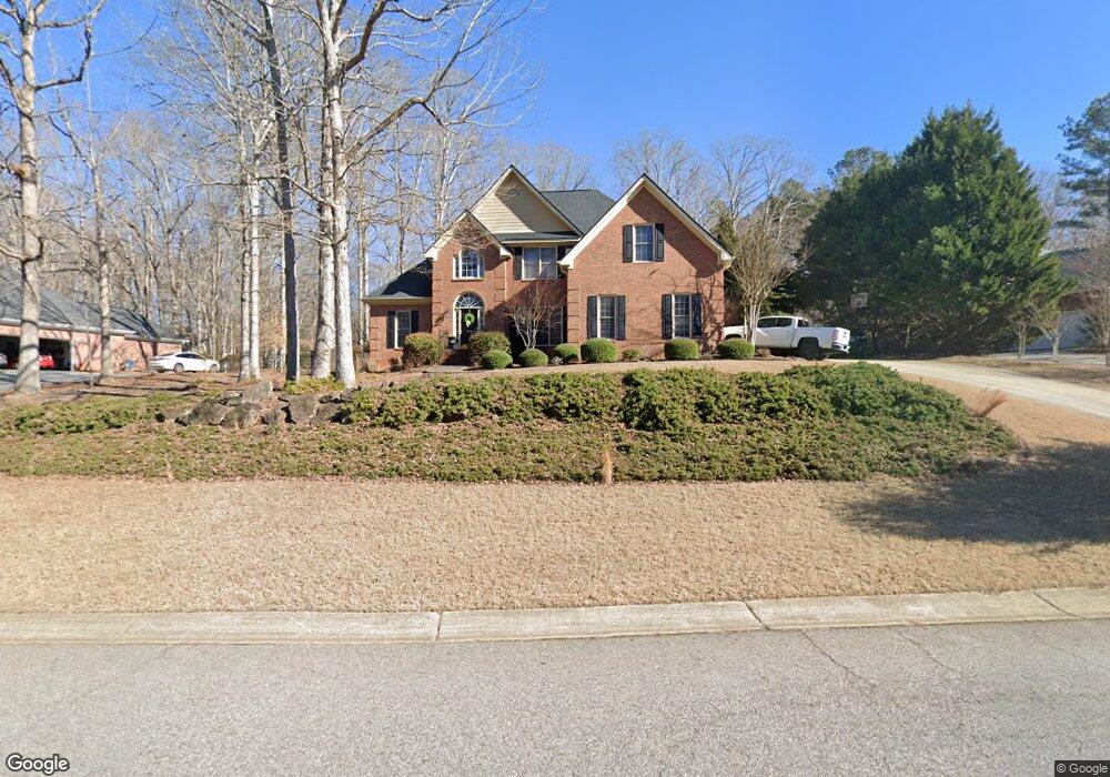
270 River Bottom Rd Athens, GA 30606
Estimated Value: $481,000 - $516,000
5
Beds
3
Baths
2,867
Sq Ft
$173/Sq Ft
Est. Value
About This Home
This home is located at 270 River Bottom Rd, Athens, GA 30606 and is currently estimated at $497,101, approximately $173 per square foot. 270 River Bottom Rd is a home located in Clarke County with nearby schools including Timothy Elementary School, Clarke Middle School, and Clarke Central High School.
Ownership History
Date
Name
Owned For
Owner Type
Purchase Details
Closed on
Nov 17, 2003
Sold by
D & F Construction Company Inc
Bought by
Edwards Melanie and Stark Andrew Davi
Current Estimated Value
Purchase Details
Closed on
Jul 18, 2000
Sold by
Creative Abundance Llc
Bought by
D & F Construction Company Inc
Create a Home Valuation Report for This Property
The Home Valuation Report is an in-depth analysis detailing your home's value as well as a comparison with similar homes in the area
Purchase History
| Date | Buyer | Sale Price | Title Company |
|---|---|---|---|
| Edwards Melanie | $275,000 | -- | |
| D & F Construction Company Inc | $40,000 | -- |
Source: Public Records
Tax History
| Year | Tax Paid | Tax Assessment Tax Assessment Total Assessment is a certain percentage of the fair market value that is determined by local assessors to be the total taxable value of land and additions on the property. | Land | Improvement |
|---|---|---|---|---|
| 2025 | $5,844 | $188,204 | $24,000 | $164,204 |
| 2024 | $5,844 | $177,475 | $24,000 | $153,475 |
| 2023 | $5,546 | $164,483 | $24,000 | $140,483 |
| 2022 | $4,436 | $139,064 | $24,000 | $115,064 |
| 2021 | $4,202 | $124,701 | $24,000 | $100,701 |
| 2020 | $4,152 | $123,204 | $24,000 | $99,204 |
| 2019 | $4,148 | $122,191 | $24,000 | $98,191 |
| 2018 | $3,960 | $116,641 | $24,000 | $92,641 |
| 2017 | $3,726 | $109,755 | $24,000 | $85,755 |
| 2016 | $3,611 | $106,347 | $24,000 | $82,347 |
| 2015 | $3,648 | $107,283 | $24,000 | $83,283 |
| 2014 | $3,606 | $105,896 | $24,000 | $81,896 |
Source: Public Records
Map
Nearby Homes
- 256 Cherokee Ridge
- 175 New Haven Dr
- 470 Huntington Rd Unit 5
- 460 Huntington Rd
- 400 Providence Rd
- 212 Huntington Shoals Dr
- 306 Providence Rd
- 118 Woodhaven Terrace
- 637 Huntington Rd Unit C2
- 637 Huntington Rd Unit 2
- 637 Huntington Rd Unit B1
- 164 Lucy Ln
- 860 Mitchell Bridge Rd Unit 8
- 184 Hillsborough Dr
- 150 The Preserve Dr Unit H2
- 284 Meeler Cir
- 201 Chesterfield Rd
- 170 Huntington Ct
- 575 Vaughn Rd
- 240 W Huntington Rd
- 260 River Bottom Rd
- 280 River Bottom Rd
- 235 New Haven Dr
- 265 River Bottom Rd
- 275 River Bottom Rd
- 250 River Bottom Rd
- 285 River Bottom Rd
- 261 River Bottom Rd
- 261 Riverbottom Creek Rd
- 250 New Haven Dr
- 255 River Bottom Rd
- 305 River Bottom Rd
- 240 River Bottom Rd
- 300 River Bottom Rd
- 245 River Bottom Rd
- 240 New Haven Dr
- 230 Austin Dr
- 215 New Haven Dr
- 220 River Bottom Rd
- 220 River Bottom Rd Unit Lot 23
Your Personal Tour Guide
Ask me questions while you tour the home.