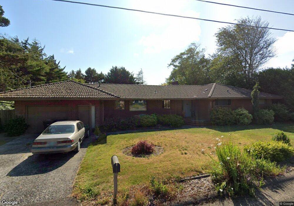
270 SE Penter Ln Newport, OR 97365
Bayfront NeighborhoodEstimated Value: $498,000 - $582,135
3
Beds
2
Baths
1,712
Sq Ft
$317/Sq Ft
Est. Value
About This Home
This home is located at 270 SE Penter Ln, Newport, OR 97365 and is currently estimated at $542,534, approximately $316 per square foot. 270 SE Penter Ln is a home located in Lincoln County with nearby schools including Yaquina View Elementary School, Sam Case Elementary School, and Newport High School.
Ownership History
Date
Name
Owned For
Owner Type
Purchase Details
Closed on
Jul 28, 2006
Sold by
Peterson Louise C
Bought by
Rozell Thomas R and Rozell Angela M
Current Estimated Value
Home Financials for this Owner
Home Financials are based on the most recent Mortgage that was taken out on this home.
Original Mortgage
$230,000
Outstanding Balance
$137,563
Interest Rate
6.69%
Mortgage Type
Purchase Money Mortgage
Estimated Equity
$404,971
Create a Home Valuation Report for This Property
The Home Valuation Report is an in-depth analysis detailing your home's value as well as a comparison with similar homes in the area
Home Values in the Area
Average Home Value in this Area
Purchase History
| Date | Buyer | Sale Price | Title Company |
|---|---|---|---|
| Rozell Thomas R | $320,000 | Wte |
Source: Public Records
Mortgage History
| Date | Status | Borrower | Loan Amount |
|---|---|---|---|
| Open | Rozell Thomas R | $230,000 |
Source: Public Records
Tax History Compared to Growth
Tax History
| Year | Tax Paid | Tax Assessment Tax Assessment Total Assessment is a certain percentage of the fair market value that is determined by local assessors to be the total taxable value of land and additions on the property. | Land | Improvement |
|---|---|---|---|---|
| 2024 | $6,021 | $333,680 | -- | -- |
| 2023 | $5,879 | $323,970 | $0 | $0 |
| 2022 | $5,698 | $314,540 | $0 | $0 |
| 2021 | $5,600 | $305,380 | $0 | $0 |
| 2020 | $5,467 | $296,490 | $0 | $0 |
| 2019 | $5,233 | $287,860 | $0 | $0 |
| 2018 | $5,072 | $279,480 | $0 | $0 |
| 2017 | $5,027 | $271,340 | $0 | $0 |
| 2016 | $4,920 | $263,440 | $0 | $0 |
| 2015 | $4,513 | $253,030 | $0 | $0 |
| 2014 | $4,361 | $242,870 | $0 | $0 |
| 2013 | -- | $254,560 | $0 | $0 |
Source: Public Records
Map
Nearby Homes
- 18 N Coast Hwy
- 24 N Coast Hwy
- 40 N Coast Hwy
- 62 N Coast Hwy
- 68 N Coast Hwy
- 72 N Coast Hwy
- 17 N Coast Hwy
- 80 N Coast Hwy
- 4902 SE Fogarty St
- 92 N Coast Hwy
- 98 N Coast Hwy
- 112 N Coast Hwy
- 246 NE 3rd St
- 61 N Coast Hwy
- 1222 SE 1st St
- 95 N Coast Hwy
- 182 N Coast Hwy
- 184 N Coast Hwy
- 160 N Coast Hwy
- 0 SW Bay Blvd
- 162 SE 11th St
- 248 SE Penter Ln
- 316 SE Penter Ln
- 277 SE Penter Ln
- 138 SE 11th St
- 145 SE 12th St
- 230 SE Penter Ln
- 233 SE Penter Ln
- 147 SE 11th St
- 306 SE 2nd St
- 168 SE 10th St
- 289 SE Penter Ln
- 282 SE Penter Ln
- 127 SE 11th St
- 242 SE 2nd St
- 124 SE 11th St
- 260 SE 2nd St
- 310 SE 2nd St
- 351 SE Penter Ln
- 250 SE 2nd St