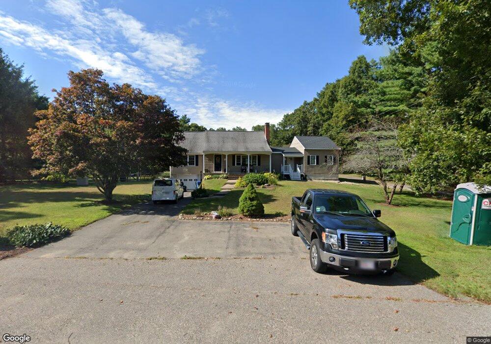
270 Thurston St Wrentham, MA 02093
Estimated Value: $647,000 - $783,981
4
Beds
3
Baths
2,308
Sq Ft
$311/Sq Ft
Est. Value
About This Home
This home is located at 270 Thurston St, Wrentham, MA 02093 and is currently estimated at $717,995, approximately $311 per square foot. 270 Thurston St is a home located in Norfolk County with nearby schools including Delaney Elementary School, Charles E Roderick, and The Sage School.
Ownership History
Date
Name
Owned For
Owner Type
Purchase Details
Closed on
Aug 30, 1999
Sold by
Bartlett Margaret A
Bought by
Munro Frank W and Munro Karen M
Current Estimated Value
Home Financials for this Owner
Home Financials are based on the most recent Mortgage that was taken out on this home.
Original Mortgage
$210,000
Interest Rate
7.53%
Mortgage Type
Purchase Money Mortgage
Create a Home Valuation Report for This Property
The Home Valuation Report is an in-depth analysis detailing your home's value as well as a comparison with similar homes in the area
Home Values in the Area
Average Home Value in this Area
Purchase History
| Date | Buyer | Sale Price | Title Company |
|---|---|---|---|
| Munro Frank W | $250,000 | -- |
Source: Public Records
Mortgage History
| Date | Status | Borrower | Loan Amount |
|---|---|---|---|
| Open | Munro Frank W | $220,000 | |
| Closed | Munro Frank W | $210,000 | |
| Previous Owner | Munro Frank W | $35,000 |
Source: Public Records
Tax History Compared to Growth
Tax History
| Year | Tax Paid | Tax Assessment Tax Assessment Total Assessment is a certain percentage of the fair market value that is determined by local assessors to be the total taxable value of land and additions on the property. | Land | Improvement |
|---|---|---|---|---|
| 2025 | $7,383 | $637,000 | $284,100 | $352,900 |
| 2024 | $7,156 | $596,300 | $284,100 | $312,200 |
| 2023 | $7,070 | $560,200 | $259,200 | $301,000 |
| 2022 | $6,693 | $489,600 | $234,300 | $255,300 |
| 2021 | $6,386 | $453,900 | $210,500 | $243,400 |
| 2020 | $5,492 | $385,400 | $193,000 | $192,400 |
| 2019 | $5,080 | $359,800 | $176,400 | $183,400 |
| 2018 | $5,185 | $364,100 | $176,200 | $187,900 |
| 2017 | $4,905 | $344,200 | $172,800 | $171,400 |
| 2016 | $4,798 | $336,000 | $167,800 | $168,200 |
| 2015 | $4,633 | $309,300 | $161,300 | $148,000 |
| 2014 | $4,588 | $299,700 | $155,200 | $144,500 |
Source: Public Records
Map
Nearby Homes
- 120 Hawes St
- 483 Thurston St
- 65 Pond St
- 362 East St
- 319 Taunton St
- 1 Lorraine Metcalf Dr
- 270 Dedham St
- 10 Nature View Dr
- 15 Nature View Dr
- 25 Foxboro Rd
- 11 Earle Stewart Ln
- 11 Goodwin Dr
- Lot 1 - Blueberry 2 Car Plan at King Philip Estates
- Lot 8 - Blueberry 2 Car Plan at King Philip Estates
- Lot 5 - Hughes 2 car Plan at King Philip Estates
- Lot 6 - Blueberry 3 Car Plan at King Philip Estates
- Lot 2 - Camden 2 Car Plan at King Philip Estates
- Lot 7 - Cedar Plan at King Philip Estates
- Lot 4 - Hemingway 2 Car Plan at King Philip Estates
- Lot 3 - Blueberry 2 Car Plan at King Philip Estates
- 263 Thurston St
- 282 Thurston St
- 271 Thurston St
- 5 Lherault Dr
- 253 Thurston St
- 279 Thurston St
- 15 Lherault Dr
- 245 Thurston St
- 4 Kelsi Way
- 285 Thurston St
- 237 Thurston St
- 10 L'Herault Dr
- 10 Lot 10 L'Herault Dr
- 10 Lherault Dr
- 228 Thurston St
- Lot 3 Kelsi Way
- Lot 1 Kelsi Way
- 299 Thurston St
- 229 Thurston St
- 25 Lherault Dr