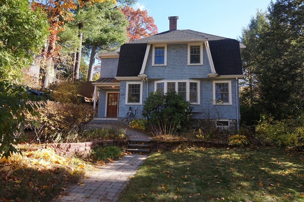


270 Upland Rd Newtonville, MA 02460
Newtonville NeighborhoodHighlights
- Golf Course Community
- Medical Services
- 1 Fireplace
- Cabot Elementary School Rated A
- Property is near public transit
- Mud Room
About This Home
Stunning single family home in a coveted Newton location. Full renovation in 2016. Moments to shops, restaurants, parks, houses of worship, library, public transit, more. First floor features a custom designed open concept kitchen/family room with oversized island, pantry, built-ins and desk area. Kitchen has 2 sinks/ovens. French doors lead directly into the back yard. Living room with fireplace, spacious dining room and half bathroom. Mud room and coat closet complete the floor. Second floor with primary suite featuring office, walk-in closet, double vanity. 3 additional bedrooms, a shared bathroom and laundry complete the floor. Relax and entertain on the blue stone patio in the back yard, with garden area, BBQ and firepit. Blueberries and strawberries grow in the yard and a storage shed is available. Basement has storage and systems. Parking for 2 cars with an electric car charger.
Home Details
Home Type
- Single Family
Est. Annual Taxes
- $14,856
Year Built
- Built in 1910
Lot Details
- 6,946 Sq Ft Lot
- Garden
Parking
- 2 Car Parking Spaces
Home Design
- Entry on the 1st floor
Interior Spaces
- 2,487 Sq Ft Home
- 1 Fireplace
- Mud Room
- Home Office
- Basement
Kitchen
- Range
- Microwave
- Freezer
- Dishwasher
- Disposal
Bedrooms and Bathrooms
- 4 Bedrooms
- Primary bedroom located on second floor
Laundry
- Laundry on upper level
- Dryer
- Washer
Outdoor Features
- Patio
Location
- Property is near public transit
- Property is near schools
Schools
- Cabot Elementary School
- Day Middle School
- Newton North High School
Utilities
- Cooling Available
- Heating System Uses Natural Gas
- High Speed Internet
Listing and Financial Details
- Security Deposit $8,500
- Property Available on 12/1/25
- Rent includes trash collection, garden area, laundry facilities, parking
- Assessor Parcel Number S:22 B:029 L:0023,685687
Community Details
Overview
- No Home Owners Association
- Electric Vehicle Charging Station
- Near Conservation Area
Amenities
- Medical Services
- Shops
Recreation
- Golf Course Community
- Tennis Courts
- Community Pool
- Park
- Jogging Path
- Bike Trail
Pet Policy
- Call for details about the types of pets allowed
Map
Source: MLS Property Information Network (MLS PIN)
MLS Number: 73451850
APN: NEWT-000022-000029-000023
Disclaimer: Certain information contained herein is derived from information provided by parties other than Homes.com. All information provided is deemed reliable, but is not guaranteed to be accurate and should be independently verified.
![]() The property listing data and information, or the Images, set forth herein were provided to MLS Property Information Network, Inc. from third party sources, including sellers, lessors and public records, and were compiled by MLS Property Information Network, Inc. The property listing data and information, and the Images, are for the personal, non-commercial use of consumers having a good faith interest in purchasing or leasing listed properties of the type displayed to them and may not be used for any purpose other than to identify prospective properties which such consumers may have a good faith interest in purchasing or leasing. MLS Property Information Network, Inc. and its subscribers disclaim any and all representations and warranties as to the accuracy of the property listing data and information, or as to the accuracy of any of the Images, set forth herein.
The property listing data and information, or the Images, set forth herein were provided to MLS Property Information Network, Inc. from third party sources, including sellers, lessors and public records, and were compiled by MLS Property Information Network, Inc. The property listing data and information, and the Images, are for the personal, non-commercial use of consumers having a good faith interest in purchasing or leasing listed properties of the type displayed to them and may not be used for any purpose other than to identify prospective properties which such consumers may have a good faith interest in purchasing or leasing. MLS Property Information Network, Inc. and its subscribers disclaim any and all representations and warranties as to the accuracy of the property listing data and information, or as to the accuracy of any of the Images, set forth herein.
- 34 Morton Rd
- 3 Cedar St
- 95 Blake St
- 887 Commonwealth Ave
- 300 Cabot St
- 44 Blake St Unit 2
- 73 Elmore St
- 110 Harvard St
- 61 Lakeview Ave
- 10 Washington Park
- 10 Washington Park Unit 2
- 10 Washington Park Unit 1
- 154 Beaumont Ave
- 22 Walnut Place Unit 1
- 48 Harvard St Unit 1
- 1004 Centre St
- Lots 2 & 3 Chapin Rd
- Lot 3 Chapin Rd
- Lot 2 Chapin Rd
- 96 E Side Pkwy
- 299 Mill St
- 36 Dexter Rd
- 113-115 Withington Rd Unit 113
- 115 Withington Rd
- 115 Withington Rd Unit 1
- 115 Withington Rd Unit 115
- 1789 Commonwealth Ave Unit 3
- 1789 Commonwealth Ave
- 1789 Commonwealth Ave
- 444 Lowell Ave Unit 2
- 73 Elm Rd Unit 4
- 73 Elm Rd Unit 8
- 47 Bridges Ave Unit 49
- 69 Crestwood Rd
- 281 Lowell Ave Unit 1
- 283 Lowell Ave Unit 1
- 76 Highland Ave Unit 1
- 28 Austin St Unit FL4-ID1229
- 28 Austin St Unit FL2-ID976
- 399 Newtonville Ave Unit 2
