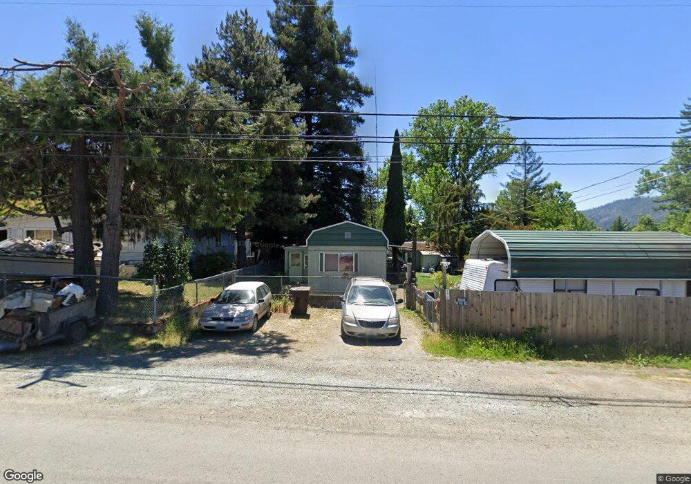
270 Walnut St Myrtle Creek, OR 97457
Estimated Value: $173,734
2
Beds
1
Bath
924
Sq Ft
$188/Sq Ft
Est. Value
About This Home
This home is located at 270 Walnut St, Myrtle Creek, OR 97457 and is currently estimated at $173,734, approximately $188 per square foot. 270 Walnut St is a home located in Douglas County with nearby schools including South Umpqua High School.
Ownership History
Date
Name
Owned For
Owner Type
Purchase Details
Closed on
Jul 23, 2024
Sold by
Ross John T
Bought by
Wilsey Donald Edward and Wilsey Debra Kay
Current Estimated Value
Purchase Details
Closed on
Nov 5, 2010
Sold by
Ross John T
Bought by
Wilsey Donald Edward and Wilsey Debra Kay
Home Financials for this Owner
Home Financials are based on the most recent Mortgage that was taken out on this home.
Original Mortgage
$64,000
Interest Rate
4.33%
Mortgage Type
Seller Take Back
Purchase Details
Closed on
Jan 21, 2010
Sold by
Ross John T and Ross Annaline M
Bought by
Ross John T
Create a Home Valuation Report for This Property
The Home Valuation Report is an in-depth analysis detailing your home's value as well as a comparison with similar homes in the area
Home Values in the Area
Average Home Value in this Area
Purchase History
| Date | Buyer | Sale Price | Title Company |
|---|---|---|---|
| Wilsey Donald Edward | -- | Amerititle | |
| Wilsey Donald Edward | $69,000 | Amerititle | |
| Ross John T | -- | None Available |
Source: Public Records
Mortgage History
| Date | Status | Borrower | Loan Amount |
|---|---|---|---|
| Previous Owner | Wilsey Donald Edward | $64,000 |
Source: Public Records
Tax History Compared to Growth
Tax History
| Year | Tax Paid | Tax Assessment Tax Assessment Total Assessment is a certain percentage of the fair market value that is determined by local assessors to be the total taxable value of land and additions on the property. | Land | Improvement |
|---|---|---|---|---|
| 2024 | $367 | $38,482 | -- | -- |
| 2023 | $356 | $37,362 | $0 | $0 |
| 2022 | $90 | $8,959 | $0 | $0 |
| 2021 | $48 | $4,266 | $0 | $0 |
| 2020 | $48 | $34,193 | $0 | $0 |
| 2019 | $58 | $6,491 | $0 | $6,491 |
| 2018 | $60 | $6,729 | $0 | $0 |
| 2017 | $44 | $31,294 | $0 | $0 |
| 2016 | $46 | $30,383 | $0 | $0 |
| 2015 | $284 | $29,499 | $0 | $0 |
| 2014 | $274 | $28,640 | $0 | $0 |
| 2013 | -- | $27,806 | $0 | $0 |
Source: Public Records
Map
Nearby Homes
- 1042 Cornutt St
- 301 Conrad St
- 1140 Arburnia St
- 972 Arburnia St
- 190 Walnut St
- 1146 Laura St
- 1048 Seeley St
- 119 Walnut St
- 1030 N Old Pacific Hwy
- 1110 N Old Pacific Hwy
- 0 N Old Pacific Hwy Unit 293835119
- 193 Clark St
- 353 Donald Terrace
- 1313 N Old Pacific Hwy
- 1383 N Old Pacific Hwy
- 184 SE Cordelia Dr
- 639 N Old Pacific Hwy
- 613 Irving Dr
- 0 SE Ardis Ave Unit 7 24085450
- 0 SE Ardis Ave Unit 9 24630388