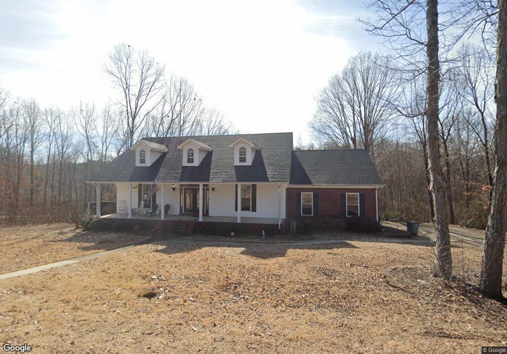
270 Westfork Dr Killen, AL 35645
Estimated Value: $302,000 - $404,000
3
Beds
1
Bath
2,100
Sq Ft
$167/Sq Ft
Est. Value
About This Home
This home is located at 270 Westfork Dr, Killen, AL 35645 and is currently estimated at $350,096, approximately $166 per square foot. 270 Westfork Dr is a home located in Lauderdale County with nearby schools including Brooks Elementary School and Underwood Elementary School.
Ownership History
Date
Name
Owned For
Owner Type
Purchase Details
Closed on
Feb 3, 2021
Sold by
Nuys Ronald E Van and Nuys Sherry R
Bought by
Pruett James and Pruett Sherri
Current Estimated Value
Home Financials for this Owner
Home Financials are based on the most recent Mortgage that was taken out on this home.
Original Mortgage
$241,187
Outstanding Balance
$214,342
Interest Rate
2.6%
Mortgage Type
VA
Estimated Equity
$135,754
Purchase Details
Closed on
Feb 4, 2014
Sold by
Martin Jerry W and Martin Linda F
Bought by
Vannuyes Ronald E
Create a Home Valuation Report for This Property
The Home Valuation Report is an in-depth analysis detailing your home's value as well as a comparison with similar homes in the area
Purchase History
| Date | Buyer | Sale Price | Title Company |
|---|---|---|---|
| Pruett James | $285,000 | None Available | |
| Vannuyes Ronald E | -- | -- |
Source: Public Records
Mortgage History
| Date | Status | Borrower | Loan Amount |
|---|---|---|---|
| Open | Pruett James | $241,187 | |
| Closed | Vannuyes Ronald E | $0 |
Source: Public Records
Tax History
| Year | Tax Paid | Tax Assessment Tax Assessment Total Assessment is a certain percentage of the fair market value that is determined by local assessors to be the total taxable value of land and additions on the property. | Land | Improvement |
|---|---|---|---|---|
| 2025 | -- | $31,560 | $0 | $0 |
| 2024 | -- | $31,200 | $3,000 | $28,200 |
| 2023 | $0 | $2,760 | $2,760 | $0 |
| 2022 | $0 | $24,640 | $0 | $0 |
| 2021 | $760 | $21,920 | $0 | $0 |
| 2020 | $720 | $20,780 | $0 | $0 |
| 2019 | $688 | $19,880 | $0 | $0 |
| 2018 | $665 | $19,200 | $0 | $0 |
| 2017 | $636 | $18,380 | $0 | $0 |
| 2016 | $636 | $18,380 | $0 | $0 |
| 2015 | $636 | $18,380 | $0 | $0 |
| 2014 | $544 | $18,440 | $0 | $0 |
Source: Public Records
Map
Nearby Homes
- 0 Hwy 72 Unit 523004
- 0 Hwy 72 Unit 524420
- 000 Hwy 72
- 500 County Road 396
- 4015 Co Rd 73
- 3442 Highway 43
- 172 Smith Ln
- 93 Isabella Ct
- Lot 27 Cooper Rd
- 135 Oldenburg Dr
- 4370 County Road 34
- 235 Oldenburg Dr
- 7.62 Acres County Road 399
- 529 Dartmoor Dr
- 101 Kentwood Dr
- 153 Kentwood Dr
- 4895 County Road 73
- 47 Briarwood Dr
- 30 Eastwood Ln
- 141 Eastwood Ln
- 277 Westfork Dr
- 000 Westfork Dr
- 0 Westfork Dr
- 00 Westfork Dr
- 375 Westfork Dr
- 215 Westfork Dr
- 339 Westfork Dr
- 400 Westfork Dr
- 211 Westfork Dr
- 485 Westfork Dr
- 155 Westfork Dr
- 436 Westfork Dr
- 545 Westfork Dr
- 462 Westfork Dr
- 117 Westfork Dr
- 490 Westfork Dr
- 625 Westfork Dr
- 3050 County Road 25
- 3160 County Road 25
- 3300 County Road 25
Your Personal Tour Guide
Ask me questions while you tour the home.