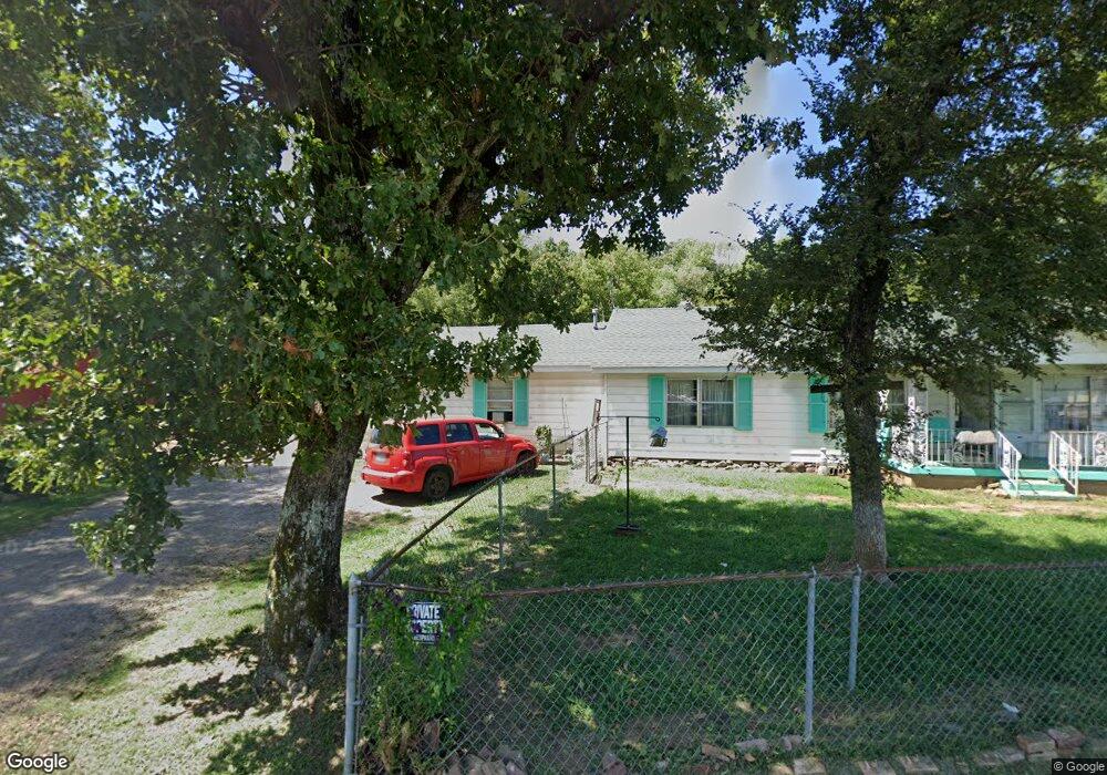
2700 Central St Poteau, OK 74953
Estimated Value: $216,000 - $241,000
3
Beds
2
Baths
1,840
Sq Ft
$126/Sq Ft
Est. Value
About This Home
This home is located at 2700 Central St, Poteau, OK 74953 and is currently estimated at $231,095, approximately $125 per square foot. 2700 Central St is a home located in Le Flore County with nearby schools including Poteau Primary Elementary School, Poteau Upper Elementary School, and Pansy Kidd Middle School.
Ownership History
Date
Name
Owned For
Owner Type
Purchase Details
Closed on
Nov 22, 2022
Sold by
Luttmer Henrietta
Bought by
Robbins Glen R and Robbins Martha A
Current Estimated Value
Purchase Details
Closed on
Jul 16, 2008
Sold by
Odom Mattie Faye
Bought by
Hampton Gary H
Home Financials for this Owner
Home Financials are based on the most recent Mortgage that was taken out on this home.
Original Mortgage
$118,400
Interest Rate
6.09%
Mortgage Type
Future Advance Clause Open End Mortgage
Create a Home Valuation Report for This Property
The Home Valuation Report is an in-depth analysis detailing your home's value as well as a comparison with similar homes in the area
Home Values in the Area
Average Home Value in this Area
Purchase History
| Date | Buyer | Sale Price | Title Company |
|---|---|---|---|
| Robbins Glen R | -- | -- | |
| Hampton Gary H | $148,000 | -- |
Source: Public Records
Mortgage History
| Date | Status | Borrower | Loan Amount |
|---|---|---|---|
| Previous Owner | Hampton Gary H | $118,400 |
Source: Public Records
Tax History Compared to Growth
Tax History
| Year | Tax Paid | Tax Assessment Tax Assessment Total Assessment is a certain percentage of the fair market value that is determined by local assessors to be the total taxable value of land and additions on the property. | Land | Improvement |
|---|---|---|---|---|
| 2025 | $623 | $7,323 | $928 | $6,395 |
| 2023 | $623 | $6,669 | $712 | $5,957 |
| 2022 | $597 | $6,669 | $884 | $5,785 |
| 2021 | $417 | $6,669 | $878 | $5,791 |
| 2020 | $418 | $6,669 | $881 | $5,788 |
| 2019 | $420 | $6,669 | $881 | $5,788 |
| 2018 | $398 | $6,669 | $881 | $5,788 |
| 2017 | $400 | $6,669 | $881 | $5,788 |
| 2016 | $397 | $6,669 | $881 | $5,788 |
| 2015 | $404 | $6,669 | $881 | $5,788 |
| 2014 | $408 | $6,669 | $881 | $5,788 |
Source: Public Records
Map
Nearby Homes
- 2880 Central St
- 108 W Dora Ln
- 102 W Dora Ln
- 401 Crest Ct
- 107 E Dora Ln
- 106 E Dora Ln
- 109 E Dora Ln
- 2902 Ash St
- 2909 Silver Maple Ln
- TBD Hughes Dr
- 103 Myra Ln
- 2917 Silver Maple Ln
- 105 Myra Ln
- 20314 Williams Ln
- 120 Redbud Ln
- 100 Winters Way
- 110 Witteville Rd
- 2200 Redwood Ln
- 20783 292nd St
- 2904 Witteville Dr
- 2900 Central St
- 2650 Central St
- 109 Cutsinger St
- 109 Cutsinger St
- 2600 Central St
- 901 Tarby Rd
- 2704 N Broadway St
- 208 Flanagan Dr
- 920 Tarby Rd
- 206 Flanagan Dr
- 2860 N Broadway
- 111 Williams Ln
- 204 Flanagan Dr
- 107 Cutsinger St
- 111 Cutsinger St
- 2825 N Broadway St
- 105 Cutsinger St
- 103 Cutsinger St
- 2713 N Broadway St
- 202 Flanagan Dr