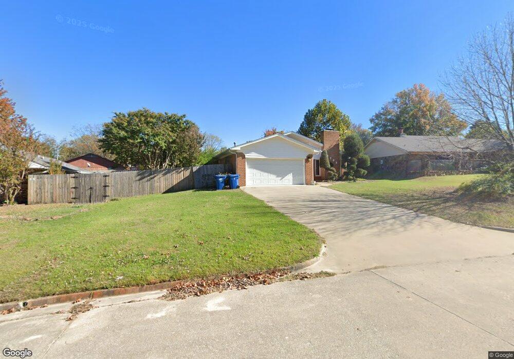
2702 Brookside Cir McAlester, OK 74501
Estimated Value: $165,000 - $185,000
3
Beds
2
Baths
1,429
Sq Ft
$124/Sq Ft
Est. Value
About This Home
This home is located at 2702 Brookside Cir, McAlester, OK 74501 and is currently estimated at $176,627, approximately $123 per square foot. 2702 Brookside Cir is a home located in Pittsburg County with nearby schools including McAlester High School, Mcalester Christian Academy, and Lakewood Christian School.
Ownership History
Date
Name
Owned For
Owner Type
Purchase Details
Closed on
Jun 15, 2021
Sold by
Burton John E and Burton Sharon M
Bought by
Lanham Rebecca A
Current Estimated Value
Home Financials for this Owner
Home Financials are based on the most recent Mortgage that was taken out on this home.
Original Mortgage
$137,464
Outstanding Balance
$123,913
Interest Rate
2.9%
Mortgage Type
FHA
Estimated Equity
$52,714
Create a Home Valuation Report for This Property
The Home Valuation Report is an in-depth analysis detailing your home's value as well as a comparison with similar homes in the area
Purchase History
| Date | Buyer | Sale Price | Title Company |
|---|---|---|---|
| Lanham Rebecca A | $140,000 | First American Title Ins Co |
Source: Public Records
Mortgage History
| Date | Status | Borrower | Loan Amount |
|---|---|---|---|
| Open | Lanham Rebecca A | $137,464 |
Source: Public Records
Tax History
| Year | Tax Paid | Tax Assessment Tax Assessment Total Assessment is a certain percentage of the fair market value that is determined by local assessors to be the total taxable value of land and additions on the property. | Land | Improvement |
|---|---|---|---|---|
| 2025 | $1,219 | $13,870 | $1,634 | $12,236 |
| 2024 | $1,219 | $14,977 | $1,634 | $13,343 |
| 2023 | $1,313 | $15,400 | $1,584 | $13,816 |
| 2022 | $1,348 | $15,400 | $1,584 | $13,816 |
| 2021 | $1,383 | $15,886 | $1,634 | $14,252 |
| 2020 | $799 | $10,112 | $1,634 | $8,478 |
| 2019 | $710 | $9,818 | $1,634 | $8,184 |
| 2018 | $692 | $9,574 | $1,634 | $7,940 |
| 2017 | $676 | $9,295 | $1,634 | $7,661 |
| 2016 | $348 | $6,286 | $807 | $5,479 |
| 2015 | $319 | $6,286 | $807 | $5,479 |
| 2014 | $319 | $6,286 | $807 | $5,479 |
Source: Public Records
Map
Nearby Homes
- 2705 Brookside Cir
- 0 Hardy Springs Cir
- 602 Flamingo Rd
- 2710 Hardy Springs Rd
- 3201 Hardy Springs Rd
- 1910 Cardinal Ln
- 509 Dove Dr
- 1901 Mockingbird Ln
- 1813 Mockingbird Ln
- 1813 Nightingale Cir
- 1003 Sunnybrook
- 1803 S 9th St
- 0 Oklahoma Ave
- 1709 Virginia Dr
- 1710 Louise Dr
- 3101 Hardy Springs Rd
- 3001 Hardy Springs Rd
- 1708 Louise Dr
- 1705 Virginia Dr
- 9 Edgewood Dr
- 2704 Brookside Cir
- 806 Hardy Springs Cir
- 2703 Highland Terrace
- 2705 Highland Terrace
- 808 Hardy Springs Cir
- 2706 Brookside Cir
- 2707 Highland Terrace
- 2708 Brookside Cir
- 2709 Highland Terrace
- 2703 Brookside Cir
- 809 Hardy Springs Cir
- 807 Hardy Springs Cir
- 811 Hardy Springs Cir
- 802 Hardy Springs Cir
- 2710 Brookside Cir
- 805 Hardy Springs Cir
- 2711 Highland Terrace
- 813 Hardy Springs Cir
- 2702 Highland Terrace
- 2700 Highland Terrace
Your Personal Tour Guide
Ask me questions while you tour the home.