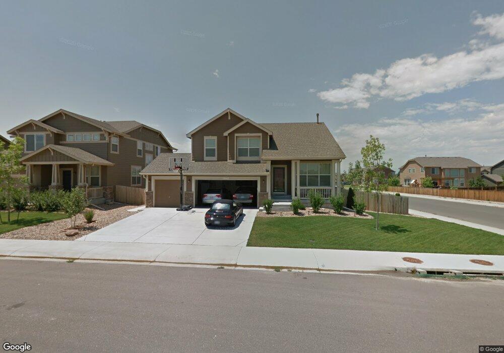
2702 S Muscovey Ln Johnstown, CO 80534
Estimated Value: $569,697 - $596,000
4
Beds
4
Baths
1,957
Sq Ft
$296/Sq Ft
Est. Value
About This Home
This home is located at 2702 S Muscovey Ln, Johnstown, CO 80534 and is currently estimated at $579,924, approximately $296 per square foot. 2702 S Muscovey Ln is a home located in Weld County with nearby schools including Pioneer Ridge Elementary School, Milliken Middle School, and Roosevelt High School.
Ownership History
Date
Name
Owned For
Owner Type
Purchase Details
Closed on
Jul 21, 2025
Sold by
Green Michael D and Green Julie A
Bought by
Green Michael D and Green Julie A
Current Estimated Value
Home Financials for this Owner
Home Financials are based on the most recent Mortgage that was taken out on this home.
Original Mortgage
$50,000
Outstanding Balance
$49,915
Interest Rate
6.84%
Mortgage Type
New Conventional
Estimated Equity
$530,009
Purchase Details
Closed on
Jul 27, 2010
Sold by
The Ryland Group Inc
Bought by
Green Michael D and Green Julie A
Home Financials for this Owner
Home Financials are based on the most recent Mortgage that was taken out on this home.
Original Mortgage
$228,357
Interest Rate
4.76%
Mortgage Type
New Conventional
Create a Home Valuation Report for This Property
The Home Valuation Report is an in-depth analysis detailing your home's value as well as a comparison with similar homes in the area
Home Values in the Area
Average Home Value in this Area
Purchase History
| Date | Buyer | Sale Price | Title Company |
|---|---|---|---|
| Green Michael D | -- | Stewart Title Guaranty Company | |
| Green Michael D | $253,730 | Ryland Title Company |
Source: Public Records
Mortgage History
| Date | Status | Borrower | Loan Amount |
|---|---|---|---|
| Open | Green Michael D | $50,000 | |
| Previous Owner | Green Michael D | $228,357 |
Source: Public Records
Tax History Compared to Growth
Tax History
| Year | Tax Paid | Tax Assessment Tax Assessment Total Assessment is a certain percentage of the fair market value that is determined by local assessors to be the total taxable value of land and additions on the property. | Land | Improvement |
|---|---|---|---|---|
| 2025 | $3,410 | $35,760 | $9,380 | $26,380 |
| 2024 | $3,410 | $35,760 | $9,380 | $26,380 |
| 2023 | $3,202 | $38,650 | $5,750 | $32,900 |
| 2022 | $2,969 | $27,680 | $5,840 | $21,840 |
| 2021 | $3,200 | $28,480 | $6,010 | $22,470 |
| 2020 | $3,009 | $27,550 | $5,580 | $21,970 |
| 2019 | $2,353 | $27,550 | $5,580 | $21,970 |
| 2018 | $2,190 | $25,620 | $5,040 | $20,580 |
| 2017 | $2,226 | $25,620 | $5,040 | $20,580 |
| 2016 | $2,010 | $23,120 | $4,300 | $18,820 |
| 2015 | $2,037 | $23,120 | $4,300 | $18,820 |
| 2014 | $1,550 | $18,150 | $4,300 | $13,850 |
Source: Public Records
Map
Nearby Homes
- 166 Bittern Dr
- 139 Muscovey Ln
- 254 Bittern Dr
- 210 Saxony Rd
- 2507 Rouen Ln
- 370 Saxony Rd
- 2128 Redhead Dr
- 0 Tbd Rd Unit 25813854
- 0 Tbd Rd Unit 11618928
- 1842 Wood Duck Dr
- 1739 Canvasback Dr
- 1519 Mallard Dr
- 9260 Meadow Farms Dr
- 9320 Meadow Farms Dr
- 0 Tbd Cr 15
- 9360 Meadow Farms Dr
- 9411 Meadow Farms Dr
- 9441 Meadow Farms Dr
- 944 Harvard St
- 934 Harvard St
- 2708 S Muscovey Ln
- 189 Bittern Dr
- 104 Muscovey Ln
- 2714 S Muscovey Ln
- 183 Bittern Dr
- 2676 White Wing Rd
- 201 Bittern Dr
- 110 Muscovey Ln
- 2709 S Muscovey Ln
- 2720 S Muscovey Ln
- 177 Bittern Dr
- 2682 White Wing Rd
- 2715 S Muscovey Ln
- 116 Muscovey Ln
- 109 Muscovey Ln
- 2698 White Wing Rd
- 2726 S Muscovey Ln
- 213 Bittern Dr
- 171 Bittern Dr
- 190 Bittern Dr