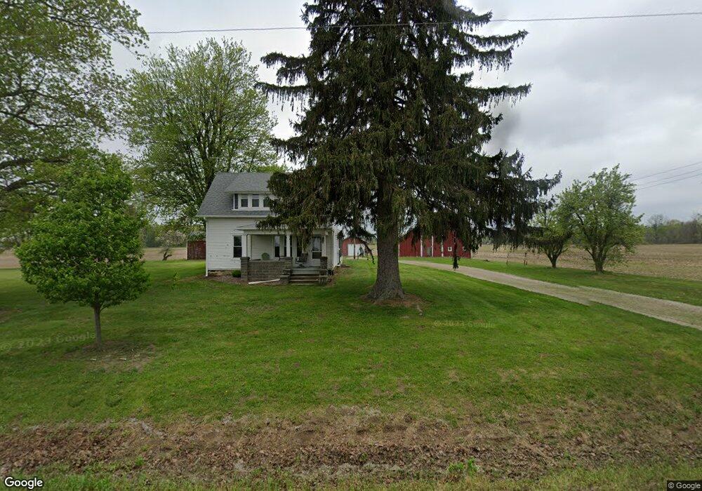
2704 Rogers Hwy Adrian, MI 49221
Estimated Value: $350,526 - $494,000
3
Beds
1
Bath
958
Sq Ft
$417/Sq Ft
Est. Value
About This Home
This home is located at 2704 Rogers Hwy, Adrian, MI 49221 and is currently estimated at $399,842, approximately $417 per square foot. 2704 Rogers Hwy is a home with nearby schools including Tecumseh Middle School and Tecumseh High School.
Ownership History
Date
Name
Owned For
Owner Type
Purchase Details
Closed on
Jul 29, 2014
Sold by
Neuman Richard and Hood Alice E
Bought by
Fisher Mark Land Llc
Current Estimated Value
Home Financials for this Owner
Home Financials are based on the most recent Mortgage that was taken out on this home.
Original Mortgage
$125,000
Outstanding Balance
$68,503
Interest Rate
4.14%
Mortgage Type
Future Advance Clause Open End Mortgage
Estimated Equity
$331,339
Purchase Details
Closed on
Oct 15, 1985
Bought by
Neuman Richard
Create a Home Valuation Report for This Property
The Home Valuation Report is an in-depth analysis detailing your home's value as well as a comparison with similar homes in the area
Home Values in the Area
Average Home Value in this Area
Purchase History
| Date | Buyer | Sale Price | Title Company |
|---|---|---|---|
| Fisher Mark Land Llc | $176,000 | Prestige Title Ins Agency | |
| Neuman Richard | -- | -- |
Source: Public Records
Mortgage History
| Date | Status | Borrower | Loan Amount |
|---|---|---|---|
| Open | Fisher Mark Land Llc | $125,000 |
Source: Public Records
Tax History Compared to Growth
Tax History
| Year | Tax Paid | Tax Assessment Tax Assessment Total Assessment is a certain percentage of the fair market value that is determined by local assessors to be the total taxable value of land and additions on the property. | Land | Improvement |
|---|---|---|---|---|
| 2025 | $2,460 | $176,800 | $0 | $0 |
| 2024 | $1,113 | $164,000 | $0 | $0 |
| 2023 | $2,385 | $158,000 | $0 | $0 |
| 2022 | $1,613 | $136,400 | $0 | $0 |
| 2021 | $1,780 | $130,900 | $0 | $0 |
| 2020 | $2,542 | $129,500 | $0 | $0 |
| 2019 | $152,507 | $125,100 | $0 | $0 |
| 2018 | $2,403 | $125,073 | $0 | $0 |
| 2017 | $3,265 | $118,612 | $0 | $0 |
| 2016 | $3,253 | $118,692 | $0 | $0 |
| 2014 | -- | $95,520 | $0 | $0 |
Source: Public Records
Map
Nearby Homes
- 3125 N Rogers Hwy
- 3198 Leeomi Dr
- 3650 Sutton Rd
- Lot 9 Crestone
- 3284 Sutton Rd
- 3508 N Wilmoth Hwy
- 6392 Mitchell Rd
- 3811 Torin Ln Unit Parcel G
- 4796 Waynick Dr
- 6000 Occidental Hwy Unit 6000 Blk Occidental
- 2600 Blk Sutton Rd Unit Parcel C
- 2000 blk Sutton Rd Unit Parcel B
- 41 Bailey Dr
- 3219 Breckel Hwy
- 2265 Occidental Hwy
- 2263 Sutton Rd
- 1966 Dawson Dr
- 2771 Gady Rd
- 2765 Gady Rd
- 4705 Robin Hood Trail
- 4757 Holloway Rd
- 4759 Holloway Rd
- 4000 Holloway Rd Blk
- 4761 Holloway Rd
- 4741 Holloway Rd
- 4767 Holloway Rd
- 4767 Holloway Rd Unit Lot 11 Meadowview
- 2901 Rogers Hwy
- 4765 Holloway Rd
- 2930 Rogers Hwy
- 4919 Holloway Rd
- 4947 Holloway Rd
- 4865 Holloway Rd
- 4865 Holloway Rd Unit HOLLOWAY
- 4997 Holloway Rd
- 4986 Holloway Rd
- 2501 Rogers Hwy
- 0 Holloway Rd
- 0 Holloway Rd
- 0 Holloway Rd