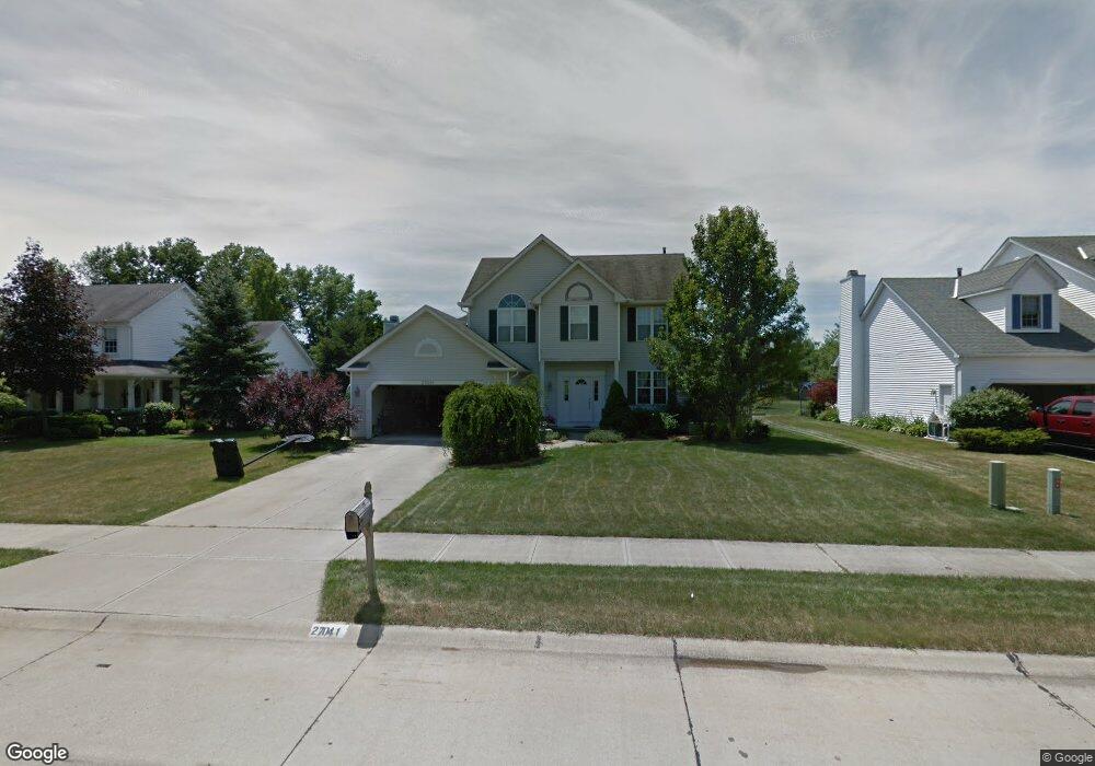
27041 Pondside Point Olmsted Falls, OH 44138
Estimated Value: $365,000 - $453,000
4
Beds
3
Baths
2,180
Sq Ft
$182/Sq Ft
Est. Value
About This Home
This home is located at 27041 Pondside Point, Olmsted Falls, OH 44138 and is currently estimated at $397,780, approximately $182 per square foot. 27041 Pondside Point is a home located in Cuyahoga County with nearby schools including Olmsted Falls Intermediate Building, Falls-Lenox Primary Elementary School, and Olmsted Falls Middle School.
Ownership History
Date
Name
Owned For
Owner Type
Purchase Details
Closed on
Jan 31, 1996
Sold by
Shore West Const Co
Bought by
Swiderski Richard M and Swiderski Sara E
Current Estimated Value
Home Financials for this Owner
Home Financials are based on the most recent Mortgage that was taken out on this home.
Original Mortgage
$175,400
Outstanding Balance
$5,870
Interest Rate
7.24%
Mortgage Type
New Conventional
Estimated Equity
$391,910
Purchase Details
Closed on
Jan 1, 1994
Bought by
Shorewest Const
Create a Home Valuation Report for This Property
The Home Valuation Report is an in-depth analysis detailing your home's value as well as a comparison with similar homes in the area
Home Values in the Area
Average Home Value in this Area
Purchase History
| Date | Buyer | Sale Price | Title Company |
|---|---|---|---|
| Swiderski Richard M | $194,900 | -- | |
| Shorewest Const | -- | -- |
Source: Public Records
Mortgage History
| Date | Status | Borrower | Loan Amount |
|---|---|---|---|
| Open | Swiderski Richard M | $175,400 |
Source: Public Records
Tax History Compared to Growth
Tax History
| Year | Tax Paid | Tax Assessment Tax Assessment Total Assessment is a certain percentage of the fair market value that is determined by local assessors to be the total taxable value of land and additions on the property. | Land | Improvement |
|---|---|---|---|---|
| 2024 | $8,319 | $111,510 | $24,675 | $86,835 |
| 2023 | $8,329 | $89,500 | $20,620 | $68,880 |
| 2022 | $8,068 | $88,800 | $20,620 | $68,180 |
| 2021 | $7,994 | $88,800 | $20,620 | $68,180 |
| 2020 | $7,902 | $77,910 | $18,100 | $59,820 |
| 2019 | $7,160 | $222,600 | $51,700 | $170,900 |
| 2018 | $6,836 | $77,910 | $18,100 | $59,820 |
| 2017 | $6,829 | $71,860 | $17,610 | $54,250 |
| 2016 | $6,798 | $71,860 | $17,610 | $54,250 |
| 2015 | $6,728 | $71,860 | $17,610 | $54,250 |
| 2014 | $6,728 | $69,760 | $17,080 | $52,680 |
Source: Public Records
Map
Nearby Homes
- 7296 Chestnut Ct
- 7224 Pine Woods Way
- 7087 Mackenzie Rd
- 7097 Stearns Rd
- 6926 Mackenzie Rd
- 27069 Oakwood Cir Unit 117W
- 27097 Oakwood Cir Unit 208Z
- 28130 Angela Dr
- 6979 Warrington Dr
- 6752 Cypress Dr
- 29651 Westminster Dr
- 27202 Cook Rd Unit 95
- 27202 Cook Rd Unit 127
- 6706 Crestwood Ln
- 6560 Mackenzie Rd
- 26946 Westwood Ln
- 6556 Louann Dr
- 29880 Westminster Dr
- 42 Periwinkle Dr
- 28628 Aspen Dr
- 27037 Pondside Point
- 27047 Pondside Point
- 27033 Pondside Point
- 27053 Pondside Point
- 27059 Pondside Point
- 27029 Pondside Point
- 27040 Pondside Point
- 27036 Pondside Point
- 27044 Pondside Point
- 27032 Pondside Point
- 27048 Pondside Point
- 27023 Pondside Point
- 27028 Pondside Point
- 27052 Pondside Point
- 27056 Pondside Point
- 27024 Pondside Point
- 27017 Pondside Point
- 27048 Laurel Ln
- 27055 Dogwood Ln
- 27050 Dogwood Ln