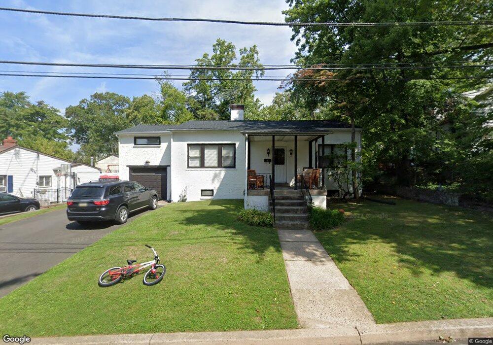
2707 Grant Ave Glenside, PA 19038
Estimated Value: $364,000 - $449,000
3
Beds
1
Bath
1,415
Sq Ft
$291/Sq Ft
Est. Value
About This Home
This home is located at 2707 Grant Ave, Glenside, PA 19038 and is currently estimated at $411,372, approximately $290 per square foot. 2707 Grant Ave is a home located in Montgomery County with nearby schools including Copper Beech Elementary School, Abington Middle School, and Abington Senior High School.
Ownership History
Date
Name
Owned For
Owner Type
Purchase Details
Closed on
Jul 31, 2018
Sold by
Grandy Andrew P and Grandy Sandra L
Bought by
Panella Matthew
Current Estimated Value
Home Financials for this Owner
Home Financials are based on the most recent Mortgage that was taken out on this home.
Original Mortgage
$197,339
Outstanding Balance
$171,381
Interest Rate
4.5%
Mortgage Type
VA
Estimated Equity
$239,991
Purchase Details
Closed on
Oct 27, 1997
Sold by
Grandy Andrew P and Grandy Sandra L
Bought by
Grandy Andrew P and Grandy Sandra L
Create a Home Valuation Report for This Property
The Home Valuation Report is an in-depth analysis detailing your home's value as well as a comparison with similar homes in the area
Home Values in the Area
Average Home Value in this Area
Purchase History
| Date | Buyer | Sale Price | Title Company |
|---|---|---|---|
| Panella Matthew | $191,500 | None Available | |
| Grandy Andrew P | -- | United General Title Ins Co |
Source: Public Records
Mortgage History
| Date | Status | Borrower | Loan Amount |
|---|---|---|---|
| Open | Panella Matthew | $197,339 |
Source: Public Records
Tax History Compared to Growth
Tax History
| Year | Tax Paid | Tax Assessment Tax Assessment Total Assessment is a certain percentage of the fair market value that is determined by local assessors to be the total taxable value of land and additions on the property. | Land | Improvement |
|---|---|---|---|---|
| 2025 | $5,726 | $123,660 | $49,360 | $74,300 |
| 2024 | $5,726 | $123,660 | $49,360 | $74,300 |
| 2023 | $5,487 | $123,660 | $49,360 | $74,300 |
| 2022 | $5,312 | $123,660 | $49,360 | $74,300 |
| 2021 | $5,026 | $123,660 | $49,360 | $74,300 |
| 2020 | $4,954 | $123,660 | $49,360 | $74,300 |
| 2019 | $4,954 | $123,660 | $49,360 | $74,300 |
| 2018 | $4,954 | $123,660 | $49,360 | $74,300 |
| 2017 | $4,808 | $123,660 | $49,360 | $74,300 |
| 2016 | $4,760 | $123,660 | $49,360 | $74,300 |
| 2015 | $4,475 | $123,660 | $49,360 | $74,300 |
| 2014 | $4,475 | $123,660 | $49,360 | $74,300 |
Source: Public Records
Map
Nearby Homes
- 2711 Taft Ave
- 229 Edge Hill Rd
- 342 Cricket Ave
- 221 Central Ave
- 441 Cricket Ave
- 0 Tyson Ave Unit PAMC2163766
- 502 Central Ave
- 624 Hamel Ave
- 2444 Fairhill Ave
- 222 Ruscombe Ave
- 65 Limekiln Pike
- 550 Penn Ave
- 623 Penn Ave
- 722 Maple Ave
- 140 Linden Ave
- 648 N Tyson Ave
- 120 Linden Ave
- 332 Logan Ave
- 0 Girard Ave
- 314 Girard Ave