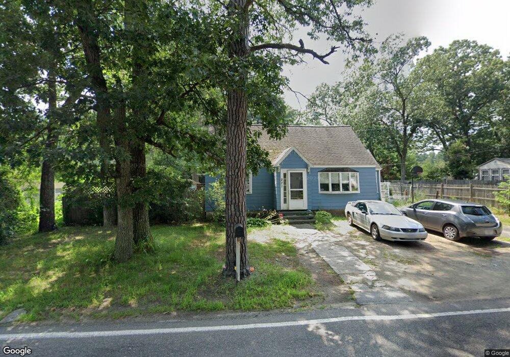
271 Foster Rd Tewksbury, MA 01876
Estimated Value: $587,000 - $683,000
4
Beds
2
Baths
1,402
Sq Ft
$457/Sq Ft
Est. Value
About This Home
This home is located at 271 Foster Rd, Tewksbury, MA 01876 and is currently estimated at $640,380, approximately $456 per square foot. 271 Foster Rd is a home located in Middlesex County with nearby schools including Heath-Brook Elementary School, John W. Wynn Middle School, and John F. Ryan Elementary School.
Ownership History
Date
Name
Owned For
Owner Type
Purchase Details
Closed on
Dec 26, 2006
Sold by
Stanley Joan L and Stanley Robert
Bought by
Stanley Gina and Stanley Joan L
Current Estimated Value
Purchase Details
Closed on
Sep 25, 1998
Sold by
Mallahan John J and Mallahan Anne R
Bought by
Stanley Robert and Stanley Joan L
Create a Home Valuation Report for This Property
The Home Valuation Report is an in-depth analysis detailing your home's value as well as a comparison with similar homes in the area
Home Values in the Area
Average Home Value in this Area
Purchase History
| Date | Buyer | Sale Price | Title Company |
|---|---|---|---|
| Stanley Gina | -- | -- | |
| Stanley Robert | $177,000 | -- |
Source: Public Records
Mortgage History
| Date | Status | Borrower | Loan Amount |
|---|---|---|---|
| Open | Stanley Robert | $307,321 | |
| Previous Owner | Stanley Robert | $47,400 | |
| Previous Owner | Stanley Robert | $29,700 |
Source: Public Records
Tax History Compared to Growth
Tax History
| Year | Tax Paid | Tax Assessment Tax Assessment Total Assessment is a certain percentage of the fair market value that is determined by local assessors to be the total taxable value of land and additions on the property. | Land | Improvement |
|---|---|---|---|---|
| 2025 | $7,169 | $542,300 | $292,800 | $249,500 |
| 2024 | $7,071 | $528,100 | $278,800 | $249,300 |
| 2023 | $6,641 | $471,000 | $253,700 | $217,300 |
| 2022 | $6,386 | $420,100 | $220,400 | $199,700 |
| 2021 | $16,462 | $385,700 | $200,400 | $185,300 |
| 2020 | $5,783 | $362,100 | $190,900 | $171,200 |
| 2019 | $5,612 | $354,300 | $181,700 | $172,600 |
| 2018 | $15,058 | $326,700 | $181,700 | $145,000 |
| 2017 | $4,978 | $305,200 | $181,700 | $123,500 |
| 2016 | $4,856 | $297,000 | $181,700 | $115,300 |
| 2015 | $4,487 | $274,100 | $176,300 | $97,800 |
| 2014 | $4,317 | $268,000 | $176,300 | $91,700 |
Source: Public Records
Map
Nearby Homes
- 70 Ronald Dr
- 27 Marie St
- 6 Stonebury Way Unit 6
- 14 Hinckley Rd
- 31 Marie St
- 1455 Main St Unit 4
- 1455 Main St Unit 10
- 1455 Main St Unit 8
- 8 Boisvert Rd
- 1418 Main St Unit 201
- 142 Patrick Rd
- 1501 Whipple Rd
- 111 Patrick Rd Unit 111
- 1042 Chandler St
- 1334 Main St
- 1325 Main
- 61 Patrick Rd
- 11 Orchard St
- 100 Pine St
- 16 Eagle Dr