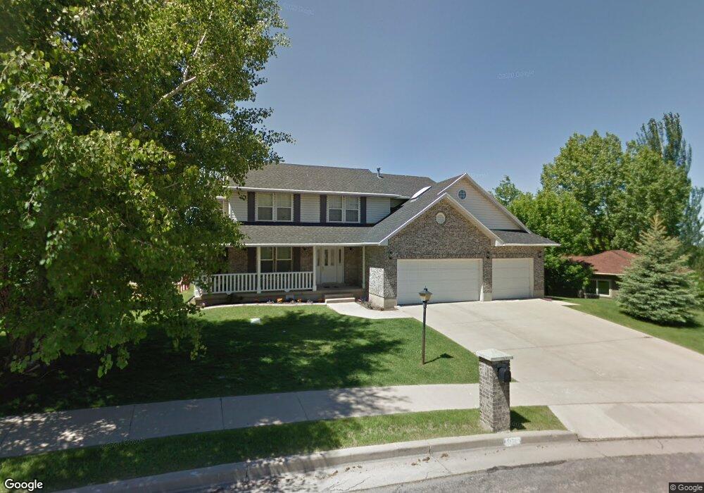
271 N 1480 E Logan, UT 84321
Wilson NeighborhoodEstimated Value: $665,000 - $852,000
6
Beds
4
Baths
4,404
Sq Ft
$169/Sq Ft
Est. Value
About This Home
This home is located at 271 N 1480 E, Logan, UT 84321 and is currently estimated at $745,552, approximately $169 per square foot. 271 N 1480 E is a home located in Cache County with nearby schools including Wilson School, Mount Logan Middle School, and Logan High School.
Ownership History
Date
Name
Owned For
Owner Type
Purchase Details
Closed on
Oct 18, 2024
Sold by
Peacock Anthony A
Bought by
Anthony Peacock Living Trust and Peacock
Current Estimated Value
Purchase Details
Closed on
Mar 13, 2024
Sold by
Anthony A Peacock A and Anthony Gretchen G
Bought by
Peacock Anthony A
Purchase Details
Closed on
Mar 6, 2024
Sold by
Peacock Gretchen
Bought by
Peacock Anthony
Purchase Details
Closed on
Jul 30, 2014
Sold by
Peacock Anthony A and Peacock Gretchen G
Bought by
Peacock Anthony A and Gretchen G Peacock F
Create a Home Valuation Report for This Property
The Home Valuation Report is an in-depth analysis detailing your home's value as well as a comparison with similar homes in the area
Home Values in the Area
Average Home Value in this Area
Purchase History
| Date | Buyer | Sale Price | Title Company |
|---|---|---|---|
| Anthony Peacock Living Trust | -- | None Listed On Document | |
| Peacock Anthony A | -- | None Listed On Document | |
| Peacock Anthony | $318,762 | None Listed On Document | |
| Peacock Anthony A | -- | None Available |
Source: Public Records
Tax History
| Year | Tax Paid | Tax Assessment Tax Assessment Total Assessment is a certain percentage of the fair market value that is determined by local assessors to be the total taxable value of land and additions on the property. | Land | Improvement |
|---|---|---|---|---|
| 2025 | $2,716 | $351,295 | $0 | $0 |
| 2024 | $2,814 | $352,495 | $0 | $0 |
| 2023 | $2,937 | $350,640 | $0 | $0 |
| 2022 | $2,910 | $324,455 | $0 | $0 |
| 2021 | $2,853 | $491,540 | $98,000 | $393,540 |
| 2020 | $2,794 | $433,225 | $98,000 | $335,225 |
| 2019 | $2,921 | $433,225 | $98,000 | $335,225 |
| 2018 | $2,876 | $389,500 | $98,000 | $291,500 |
| 2017 | $2,665 | $190,850 | $0 | $0 |
| 2016 | $2,764 | $190,850 | $0 | $0 |
| 2015 | $2,526 | $174,255 | $0 | $0 |
| 2014 | $2,283 | $174,255 | $0 | $0 |
| 2013 | -- | $174,255 | $0 | $0 |
Source: Public Records
Map
Nearby Homes
- 1387 E 260 N
- 1374 E 260 N
- 147 Winding Way Unit 50
- 128 S 1170 E
- 1034 Thrushwood Dr
- 1045 Fox Farm Rd
- 1374 Maple Dr
- 825 N 1400 E
- 866 Hillcrest Ave
- 1393 Davis Ave
- 28 River Pointe Dr
- 2758 N Canyon Cove Dr
- 2738 N Canyon Cove Dr
- 684 Apple Dr
- 661 E 600 N
- 45 River Circle Dr
- 545 E Boulevard St
- 631 E 600 N
- Cedar Ridge Plan at Foothill Lofts
- Viewside Plan at Foothill Lofts
- 270 N 1430 E
- 263 N 1480 E
- 282 N 1430 E
- 264 N 1430 E
- 280 N 1480 E
- 260 N 1480 E
- 261 N 1430 E
- 200 Quail Way
- 163 Quail Way Unit 115
- 154 Quail Way Unit 110
- 0 Quail Way Unit 113
- 1624 Quail Way
- 155 Quail Way Unit 5
- 1459 E Quail Way
- 1487 E Quail Way
- 273 N 1430 E
- 1473 E Quailway N
- 1473 E Quailway
- 312 N 1430 E
- 1524 Quail Way