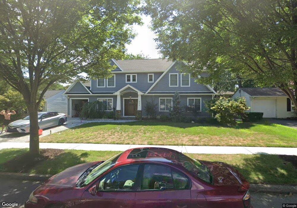
271 Olympia Dr River Edge, NJ 07661
Estimated Value: $915,000 - $1,791,000
Studio
--
Bath
3,268
Sq Ft
$401/Sq Ft
Est. Value
About This Home
This home is located at 271 Olympia Dr, River Edge, NJ 07661 and is currently estimated at $1,309,277, approximately $400 per square foot. 271 Olympia Dr is a home located in Bergen County with nearby schools including Cherry Hill School, River Dell Middle School, and River Dell Regional High School.
Ownership History
Date
Name
Owned For
Owner Type
Purchase Details
Closed on
Sep 23, 1999
Sold by
Derbalian Avedis S and Derbalian Lisa
Bought by
Derbalian Avedis S and Derbalian Lisa
Current Estimated Value
Purchase Details
Closed on
Jan 15, 1999
Sold by
Brescia Joseph A and Brescia Cynthia M
Bought by
Derbalian Avedis S and Bastian Lisa
Home Financials for this Owner
Home Financials are based on the most recent Mortgage that was taken out on this home.
Original Mortgage
$227,000
Outstanding Balance
$52,379
Interest Rate
6.7%
Mortgage Type
Purchase Money Mortgage
Estimated Equity
$1,256,898
Create a Home Valuation Report for This Property
The Home Valuation Report is an in-depth analysis detailing your home's value as well as a comparison with similar homes in the area
Home Values in the Area
Average Home Value in this Area
Purchase History
| Date | Buyer | Sale Price | Title Company |
|---|---|---|---|
| Derbalian Avedis S | -- | -- | |
| Derbalian Avedis S | $255,000 | -- |
Source: Public Records
Mortgage History
| Date | Status | Borrower | Loan Amount |
|---|---|---|---|
| Open | Derbalian Avedis S | $227,000 |
Source: Public Records
Tax History
| Year | Tax Paid | Tax Assessment Tax Assessment Total Assessment is a certain percentage of the fair market value that is determined by local assessors to be the total taxable value of land and additions on the property. | Land | Improvement |
|---|---|---|---|---|
| 2025 | $21,574 | $924,900 | $359,000 | $565,900 |
| 2024 | $21,035 | $544,100 | $206,400 | $337,700 |
| 2023 | $20,132 | $544,100 | $206,400 | $337,700 |
| 2022 | $20,132 | $544,100 | $206,400 | $337,700 |
| 2021 | $18,869 | $544,100 | $206,400 | $337,700 |
| 2020 | $19,424 | $544,100 | $206,400 | $337,700 |
| 2019 | $18,869 | $544,100 | $206,400 | $337,700 |
| 2018 | $12,090 | $356,100 | $206,400 | $149,700 |
| 2017 | $11,972 | $356,100 | $206,400 | $149,700 |
| 2016 | $11,701 | $356,100 | $206,400 | $149,700 |
| 2015 | $11,456 | $356,100 | $206,400 | $149,700 |
| 2014 | $11,477 | $356,100 | $206,400 | $149,700 |
Source: Public Records
Map
Nearby Homes
- 302 Howland Ave
- 285 Wayne Ave
- 457 the Fenway
- 374 Valley Rd
- 12 Gainesborough Terrace Unit 1B
- 81 Eastbrook Dr
- 215 Kensington Rd
- 175 Valley Rd
- 255 Bogert Rd Unit 2A
- 16 Coles Ct
- 409 Windsor Rd
- 378 Windsor Rd
- 42 Howland Ave
- 406 Kinderkamack Rd
- 122 Village Cir E
- 239 Greenway Terrace
- 127 Village Cir E
- 117 Monroe Ave
- 212 Monroe Ave
- 189 Forest Ave Unit 117
- 277 Olympia Dr
- 265 Olympia Dr
- 335 Oak Ave
- 272 Howland Ave
- 278 Howland Ave
- 283 Olympia Dr
- 266 Howland Ave
- 272 Olympia Dr
- 266 Olympia Dr
- 284 Howland Ave
- 278 Olympia Dr
- 262 Olympia Dr
- 289 Olympia Dr
- 284 Olympia Dr
- 290 Howland Ave
- 324 Oak Ave
- 195 Beech Dr S
- 277 Howland Ave
- 205 Beech Dr S
- 271 Howland Ave
Your Personal Tour Guide
Ask me questions while you tour the home.