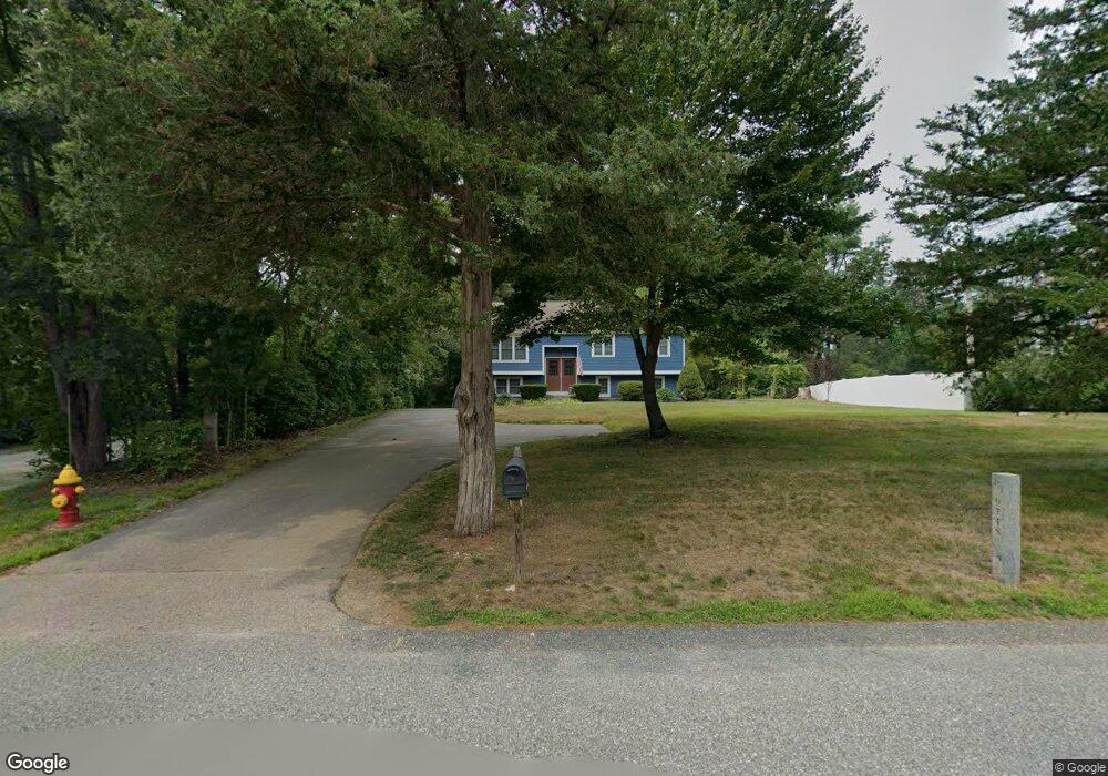
271 Otis St Mansfield, MA 02048
Estimated Value: $659,000 - $951,000
3
Beds
2
Baths
1,779
Sq Ft
$432/Sq Ft
Est. Value
About This Home
This home is located at 271 Otis St, Mansfield, MA 02048 and is currently estimated at $767,713, approximately $431 per square foot. 271 Otis St is a home located in Bristol County with nearby schools including Everett W. Robinson Elementary School, Jordan/Jackson Elementary School, and Harold L. Qualters Middle School.
Ownership History
Date
Name
Owned For
Owner Type
Purchase Details
Closed on
Dec 31, 2003
Sold by
Busa Audry L
Bought by
Gagne Francis and Gagne Vidalia L
Current Estimated Value
Home Financials for this Owner
Home Financials are based on the most recent Mortgage that was taken out on this home.
Original Mortgage
$190,000
Outstanding Balance
$88,609
Interest Rate
5.86%
Mortgage Type
Purchase Money Mortgage
Estimated Equity
$679,104
Create a Home Valuation Report for This Property
The Home Valuation Report is an in-depth analysis detailing your home's value as well as a comparison with similar homes in the area
Home Values in the Area
Average Home Value in this Area
Purchase History
| Date | Buyer | Sale Price | Title Company |
|---|---|---|---|
| Gagne Francis | $340,000 | -- |
Source: Public Records
Mortgage History
| Date | Status | Borrower | Loan Amount |
|---|---|---|---|
| Open | Gagne Francis | $190,000 |
Source: Public Records
Tax History Compared to Growth
Tax History
| Year | Tax Paid | Tax Assessment Tax Assessment Total Assessment is a certain percentage of the fair market value that is determined by local assessors to be the total taxable value of land and additions on the property. | Land | Improvement |
|---|---|---|---|---|
| 2025 | $7,874 | $597,900 | $248,400 | $349,500 |
| 2024 | $7,556 | $559,700 | $248,400 | $311,300 |
| 2023 | $7,325 | $519,900 | $248,400 | $271,500 |
| 2022 | $7,077 | $466,500 | $230,000 | $236,500 |
| 2021 | $6,818 | $443,900 | $201,300 | $242,600 |
| 2020 | $6,768 | $440,600 | $191,700 | $248,900 |
| 2019 | $6,219 | $408,600 | $159,700 | $248,900 |
| 2018 | $5,951 | $382,200 | $152,300 | $229,900 |
| 2017 | $5,741 | $382,200 | $148,100 | $234,100 |
| 2016 | $5,682 | $368,700 | $140,900 | $227,800 |
| 2015 | $5,224 | $337,000 | $140,900 | $196,100 |
Source: Public Records
Map
Nearby Homes
- 176 Elm St
- 451R Gilbert St
- 150 Gilbert St
- 2 Oak St Unit 2D
- 2 Oak St Unit 2A
- 2 Oak St Unit 2C
- 2 Oak St Unit 2B
- 255 Mckeon Dr
- 37 Oakleaf Dr
- 4 Buckskin Dr
- 14 Country Club Way
- 24 Maverick Dr
- 196 Donald Tennant Cir
- 115 Westfield Dr
- 11 Buckthorn Ln
- 250 Mansfield Ave Unit 66
- 4 Village Way Unit F
- 11 Landry Ave
- 21 Shady Ln
- 20 Sperry Ln