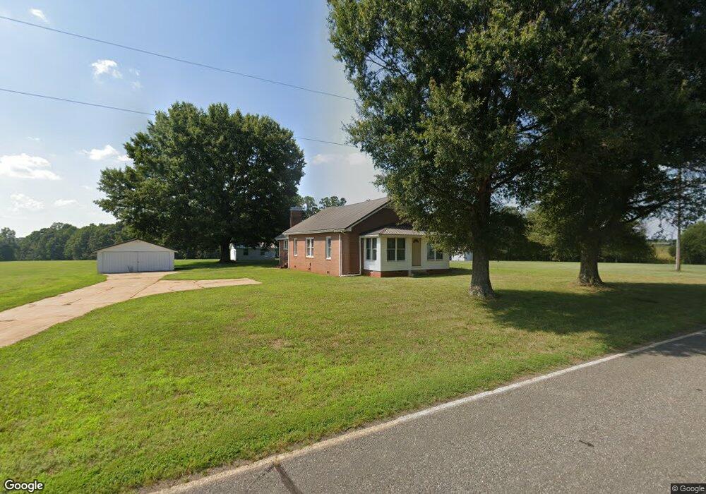
271 Pope Farm Rd Stony Point, NC 28678
Estimated Value: $339,000 - $388,803
3
Beds
1
Bath
1,552
Sq Ft
$231/Sq Ft
Est. Value
About This Home
This home is located at 271 Pope Farm Rd, Stony Point, NC 28678 and is currently estimated at $358,451, approximately $230 per square foot. 271 Pope Farm Rd is a home located in Iredell County with nearby schools including Sharon Elementary School, West Iredell Middle School, and West Iredell High School.
Ownership History
Date
Name
Owned For
Owner Type
Purchase Details
Closed on
Aug 27, 2025
Sold by
Joyce Sonia Elder and Kim Darcy
Bought by
Ashcraft Danny Keith and Ashcraft Shannon Dillard
Current Estimated Value
Purchase Details
Closed on
May 28, 2025
Sold by
Elder Joyce Miller
Bought by
Elder Joyce Miller and Joyce Sonia Elder
Purchase Details
Closed on
Sep 15, 1998
Sold by
Elder Joyce Miller and Elder Ralph Steven
Bought by
Selves Sonia Elder
Purchase Details
Closed on
Dec 1, 1995
Create a Home Valuation Report for This Property
The Home Valuation Report is an in-depth analysis detailing your home's value as well as a comparison with similar homes in the area
Home Values in the Area
Average Home Value in this Area
Purchase History
| Date | Buyer | Sale Price | Title Company |
|---|---|---|---|
| Ashcraft Danny Keith | $350,000 | None Listed On Document | |
| Elder Joyce Miller | -- | None Listed On Document | |
| Elder Joyce Miller | -- | None Listed On Document | |
| Selves Sonia Elder | -- | -- | |
| -- | -- | -- |
Source: Public Records
Tax History Compared to Growth
Tax History
| Year | Tax Paid | Tax Assessment Tax Assessment Total Assessment is a certain percentage of the fair market value that is determined by local assessors to be the total taxable value of land and additions on the property. | Land | Improvement |
|---|---|---|---|---|
| 2024 | $2,117 | $328,510 | $246,070 | $82,440 |
| 2023 | $1,998 | $328,510 | $246,070 | $82,440 |
| 2022 | $1,310 | $199,910 | $147,640 | $52,270 |
| 2021 | $1,310 | $199,910 | $147,640 | $52,270 |
| 2020 | $1,310 | $199,910 | $147,640 | $52,270 |
| 2019 | $1,290 | $199,910 | $147,640 | $52,270 |
| 2018 | $1,232 | $197,520 | $147,640 | $49,880 |
| 2017 | $1,232 | $197,520 | $147,640 | $49,880 |
| 2016 | $1,232 | $197,520 | $147,640 | $49,880 |
| 2015 | $525 | $197,520 | $147,640 | $49,880 |
| 2014 | -- | $198,790 | $147,640 | $51,150 |
Source: Public Records
Map
Nearby Homes
- 1834 Island Ford Rd
- 230 Mock Mill Rd
- 214 Mock Mill Rd
- 462 Mock Mill Rd
- 152 Colonial Heights Ln
- 126 Top Flite Dr
- 163 Whitney Ln
- 112 Robinette Ln
- 0 Lippard Farm Rd
- 127 Walnut Tree Rd
- 129 Broken Arrow Dr Unit 2
- 368 Lippard Farm Rd
- 153 Larue Cir
- 239 Old Lion Rd
- 138 Broken Arrow Dr
- 275 Broken Arrow Dr Unit 26
- 148 Broken Arrow Dr
- 268 Broken Arrow Dr
- 3662 Hickory Hwy
- 260 Broken Arrow Dr
- 270 Pope Farm Rd Unit 276
- 276 Pope Farm Rd
- 256 Pope Farm Rd
- 232 Pope Farm Rd
- 231 Pope Farm Rd Unit 235
- 225 Pope Farm Rd
- 217 Pope Farm Rd
- 213 Pope Farm Rd
- 193 Pope Farm Rd
- 1802 Island Ford Rd
- 150 Sportsman Dr
- 1728 Island Ford Rd
- 175 Wilhelm Ln
- 1712 Island Ford Rd
- 1719 Island Ford Rd
- 133 Sportsman Dr
- 282 Cotton Gin Rd
- 282 Cotton Gin Rd
- 153 Wilhelm Ln
- 400 Cotton Gin Rd