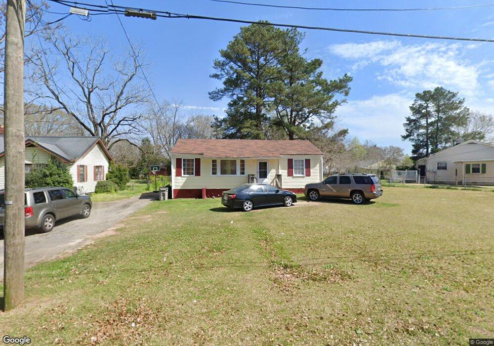
271 Rutland Cir Lagrange, GA 30241
Estimated Value: $91,000 - $158,000
3
Beds
1
Bath
1,000
Sq Ft
$124/Sq Ft
Est. Value
About This Home
This home is located at 271 Rutland Cir, Lagrange, GA 30241 and is currently estimated at $124,045, approximately $124 per square foot. 271 Rutland Cir is a home located in Troup County with nearby schools including Franklin Forest Elementary School, Hollis Hand Elementary School, and Ethel W. Kight Elementary School.
Ownership History
Date
Name
Owned For
Owner Type
Purchase Details
Closed on
Apr 28, 2023
Sold by
Kinney Beatrix G
Bought by
Pastpluto Llc
Current Estimated Value
Purchase Details
Closed on
May 15, 2018
Sold by
Swanson Hilton E
Bought by
Silny Rona
Purchase Details
Closed on
Aug 18, 2009
Sold by
Federal National Mortgage Association
Bought by
Swanson Hilton
Purchase Details
Closed on
Jul 16, 2007
Sold by
Adams Trina
Bought by
Scott Joshua Shane
Home Financials for this Owner
Home Financials are based on the most recent Mortgage that was taken out on this home.
Original Mortgage
$72,000
Interest Rate
6.71%
Mortgage Type
New Conventional
Purchase Details
Closed on
Aug 30, 2002
Sold by
Clifford D Smith
Bought by
Trina L Bonner
Purchase Details
Closed on
Oct 1, 1963
Sold by
Olson Carl J
Bought by
Clifford D Smith
Create a Home Valuation Report for This Property
The Home Valuation Report is an in-depth analysis detailing your home's value as well as a comparison with similar homes in the area
Purchase History
| Date | Buyer | Sale Price | Title Company |
|---|---|---|---|
| Pastpluto Llc | -- | -- | |
| Silny Rona | $62,500 | -- | |
| Swanson Hilton | -- | -- | |
| Swanson Hilton | -- | -- | |
| Scott Joshua Shane | $68,000 | -- | |
| Trina L Bonner | $71,700 | -- | |
| Clifford D Smith | -- | -- |
Source: Public Records
Mortgage History
| Date | Status | Borrower | Loan Amount |
|---|---|---|---|
| Previous Owner | Scott Joshua Shane | $72,000 |
Source: Public Records
Tax History
| Year | Tax Paid | Tax Assessment Tax Assessment Total Assessment is a certain percentage of the fair market value that is determined by local assessors to be the total taxable value of land and additions on the property. | Land | Improvement |
|---|---|---|---|---|
| 2025 | $1,029 | $37,720 | $8,000 | $29,720 |
| 2024 | $924 | $33,880 | $8,000 | $25,880 |
| 2023 | $928 | $34,040 | $7,880 | $26,160 |
| 2022 | $915 | $32,800 | $7,880 | $24,920 |
| 2021 | $779 | $25,840 | $7,880 | $17,960 |
| 2020 | $779 | $25,840 | $7,880 | $17,960 |
| 2019 | $630 | $20,880 | $7,080 | $13,800 |
| 2018 | $630 | $20,892 | $7,092 | $13,800 |
| 2017 | $630 | $20,892 | $7,092 | $13,800 |
| 2016 | $616 | $20,434 | $7,092 | $13,342 |
| 2015 | $617 | $20,434 | $7,092 | $13,342 |
| 2014 | $597 | $19,732 | $7,092 | $12,640 |
| 2013 | -- | $20,646 | $7,092 | $13,554 |
Source: Public Records
Map
Nearby Homes
- 87 Youngs Mill Rd
- 224 Rutland Cir
- 204 Cleveland Dr
- 203 Bonaventure Dr
- 212 Cleveland Dr
- 115 Clara Jean Ct
- 210 Hearthstone Dr
- 110 Lenox Cir
- 5 Curran Ave
- 0 N Barnard Ave
- 107 N Barnard Ave
- 616 S Harlem Cir
- 706 N Harlem Cir
- 4 1/2 Barnard Ave
- 131 Foch St
- 121 de Groat St
- 101 Sarah Ln
- 412 Sweetwood Ct Unit A36
- 109 Sarah Ln
- 304 Bridgette Blvd
- 269 Rutland Cir
- 273 Rutland Cir
- 267 Rutland Cir
- 100 Rutland Cir
- 100 Rutland Cir Unit 8
- 115 Youngs Mill Rd
- 236 Rutland Cir
- 119 Youngs Mill Rd
- 238 Rutland Cir
- 265 Rutland Cir
- 234 Rutland Cir
- 129 Youngs Mill Rd
- 101 Youngs Mill Rd
- 200 Rutland Cir
- 133 Youngs Mill Rd
- 105 Rutland Cir
- 232 Rutland Cir
- 107 Rutland Cir
- 263 Rutland Cir
- 263 Rutland Cir Unit 14
Your Personal Tour Guide
Ask me questions while you tour the home.