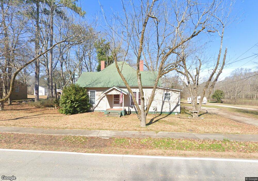
271 S Broad St Bowman, GA 30624
Estimated Value: $134,704 - $184,000
Studio
2
Baths
1,436
Sq Ft
$117/Sq Ft
Est. Value
About This Home
This home is located at 271 S Broad St, Bowman, GA 30624 and is currently estimated at $167,676, approximately $116 per square foot. 271 S Broad St is a home located in Elbert County with nearby schools including Elbert County Elementary School, Elbert County Primary School, and Elbert County Middle School.
Ownership History
Date
Name
Owned For
Owner Type
Purchase Details
Closed on
Apr 26, 2002
Sold by
Randall Shirley T
Bought by
Shirley Shirley T and Shirley Debra S
Current Estimated Value
Purchase Details
Closed on
May 1, 1990
Purchase Details
Closed on
May 17, 1987
Sold by
Bradfiel Louie J
Bought by
Bradfield George F
Purchase Details
Closed on
Oct 1, 1981
Purchase Details
Closed on
Feb 9, 1979
Sold by
Campbell Campbell W and Campbell A
Bought by
Bradfield Louie J
Purchase Details
Closed on
Feb 1, 1979
Purchase Details
Closed on
Sep 1, 1978
Purchase Details
Closed on
Oct 18, 1973
Sold by
Bowman State Bank
Bought by
Segars Thomas H
Purchase Details
Closed on
Jun 17, 1972
Sold by
Burden Harold and Burden Della
Bought by
Segars Thomas H
Purchase Details
Closed on
Aug 11, 1970
Sold by
Dudley Cora
Bought by
Burden Harold and Burden Della
Create a Home Valuation Report for This Property
The Home Valuation Report is an in-depth analysis detailing your home's value as well as a comparison with similar homes in the area
Purchase History
| Date | Buyer | Sale Price | Title Company |
|---|---|---|---|
| Shirley Shirley T | -- | -- | |
| -- | $29,900 | -- | |
| Bradfield George F | -- | -- | |
| -- | -- | -- | |
| Bradfield Louie J | -- | -- | |
| -- | $6,500 | -- | |
| -- | $4,700 | -- | |
| -- | -- | -- | |
| Segars Thomas H | -- | -- | |
| Segars Thomas H | -- | -- | |
| Burden Harold | -- | -- |
Source: Public Records
Tax History
| Year | Tax Paid | Tax Assessment Tax Assessment Total Assessment is a certain percentage of the fair market value that is determined by local assessors to be the total taxable value of land and additions on the property. | Land | Improvement |
|---|---|---|---|---|
| 2025 | $1,337 | $56,123 | $4,600 | $51,523 |
| 2024 | $1,272 | $51,707 | $4,000 | $47,707 |
| 2023 | $1,272 | $51,707 | $4,000 | $47,707 |
| 2022 | $812 | $32,993 | $3,400 | $29,593 |
| 2021 | $818 | $32,993 | $3,400 | $29,593 |
| 2020 | $847 | $30,726 | $4,000 | $26,726 |
| 2019 | $875 | $30,726 | $4,000 | $26,726 |
| 2018 | $894 | $30,726 | $4,000 | $26,726 |
| 2017 | $825 | $26,252 | $4,000 | $22,252 |
| 2016 | $771 | $26,252 | $4,000 | $22,252 |
| 2015 | -- | $26,252 | $4,000 | $22,252 |
| 2014 | -- | $26,252 | $4,000 | $22,252 |
| 2013 | -- | $26,768 | $4,000 | $22,768 |
Source: Public Records
Map
Nearby Homes
- 225 Rehoboth Rd
- 100 S Broad St
- 494 S Broad St
- 0 Bowers St Unit LOT 1-8 10576344
- 0 Bowers St Unit LOT 1-8
- 231 Roosevelt Cir
- 260 Roosevelt Cir
- 0 Five Forks Rd Unit 10619685
- 8714 Georgia 172
- 3065 Sycamore Rd
- 2115 Dusty Rd
- 0 Dusty Rd Unit 10569563
- 0 Dusty Rd Unit 7619983
- 0 Jess Guest Rd Unit CL336922
- 0 Jess Guest Rd Unit 10713982
- 0 Jess Guest Rd Unit 10586921
- 0 Jess Guest Rd Unit CL351681
- 2661 Brickyard Rd
- 0 Fork Creek Rd Unit CL350628
- 0 Fork Creek Rd Unit 7728987
- 283 S Broad St
- S Broad St
- 261 S Broad St
- 298 S Broad St
- 297 S Broad St
- 241 S Broad St
- 307 S Broad St
- 319 S Broad St
- 313 S Broad St
- 322 S Broad St
- 333 S Broad St
- 264 S Broad St
- 340 S Broad St
- 197 S Broad St
- 196 S Broad St
- 351 S Broad St
- 177 S Broad St
- 259 Rehoboth Rd
- 191 Rehoboth Rd
- 45 W Hendricks St
Your Personal Tour Guide
Ask me questions while you tour the home.