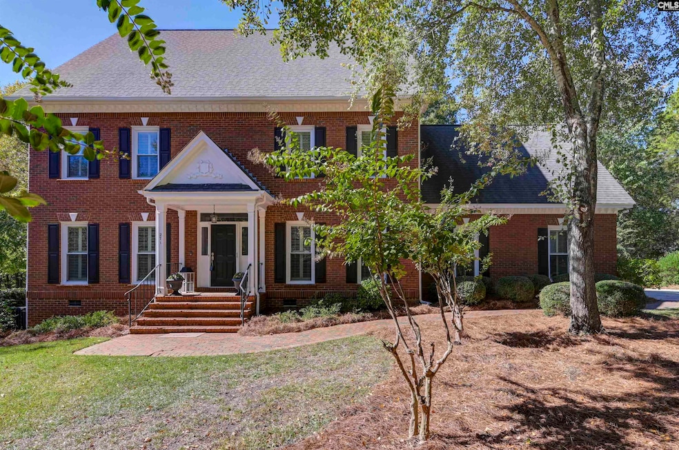
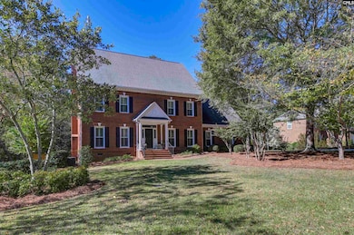
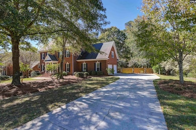
271 Sheringham Rd Columbia, SC 29212
Northwest Columbia NeighborhoodEstimated payment $3,827/month
Highlights
- Deck
- Traditional Architecture
- Screened Porch
- Irmo Elementary School Rated A
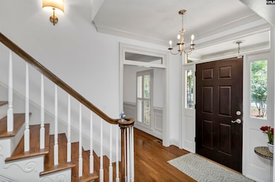
- 1 Fireplace
- Crown Molding
About This Home
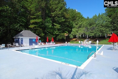
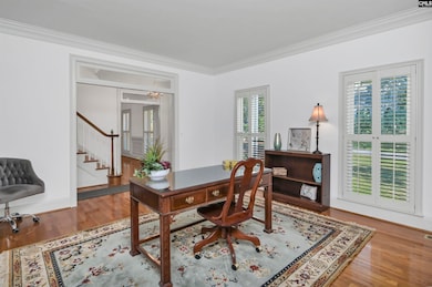
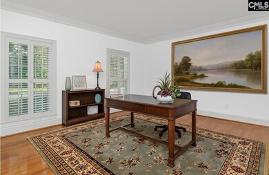
Welcome to 271 Sheringham Road, a stately and spacious home nestled in the sought-after Sheffield neighborhood of Columbia. With over 4,300 square feet of beautifully maintained living space, this home has a perfect blend of elegance, comfort, and everyday functionality. From the moment you step through the front door, you’re greeted by an inviting foyer that opens to formal living and dining rooms accented by hardwood floors, crown molding, and an abundance of natural light. The layout flows seamlessly into a warm and welcoming family room—perfect for relaxing evenings or entertaining guests.At the heart of the home is a thoughtfully designed kitchen featuring ample cabinetry, generous counter space, and a bright casual dining area that connects easily to the main living spaces. The expansive primary suite provides a peaceful retreat complete with a spa-like bathroom and spacious closets. With five to six bedrooms and a large finished room over the garage, this home has flexibility for a home office, guest suite, playroom, or media room—whatever best fits your lifestyle.Outside, the property continues to impress with a large deck, sunroom, and privatebackyard surrounded by mature landscaping—an ideal setting for outdoor entertaining or quiet relaxation. Sitting on more than half an acre, the home provides the space and privacy rarely found in such a convenient Columbia location.The Sheffield neighborhood is known for its established charm, tree-lined streets, and welcoming community atmosphere. Residents enjoy access to exceptional amenities, including a sparkling neighborhood pool and clubhouse, creating the perfect environment for gathering with family, friends, and neighbors. The community also hosts seasonal events and get-togethers that foster a true sense of connection. Located just minutes from shopping, dining, top-rated schools, and Lake Murray, Sheffield has the best of both worlds—peaceful suburban living with easy access to all that Columbia has.With its timeless design, spacious floor plan, and prime location in one of Irmo’s most desirable neighborhoods, 271 Sheringham Road is more than just a house, its home. Disclaimer: CMLS has not reviewed a
Home Details
Home Type
- Single Family
Est. Annual Taxes
- $2,234
Year Built
- Built in 1993
Lot Details
- 0.53 Acre Lot
- Privacy Fence
- Wood Fence
- Back Yard Fenced
- Sprinkler System
HOA Fees
- $77 Monthly HOA Fees
Parking
- 2 Car Garage
Home Design
- Traditional Architecture
- Four Sided Brick Exterior Elevation
Interior Spaces
- 4,317 Sq Ft Home
- 3-Story Property
- Crown Molding
- 1 Fireplace
- Screened Porch
- Crawl Space
- Laundry on main level
Bedrooms and Bathrooms
- 5 Bedrooms
Outdoor Features
- Deck
- Exterior Lighting
Schools
- Irmo Elementary And Middle School
- Crossroad Intermediate
- Irmo High School
- School of Choice Available
Utilities
- Central Heating and Cooling System
Community Details
- Town And Country HOA
- Sheffield Subdivision
Map
Home Values in the Area
Average Home Value in this Area
Tax History
| Year | Tax Paid | Tax Assessment Tax Assessment Total Assessment is a certain percentage of the fair market value that is determined by local assessors to be the total taxable value of land and additions on the property. | Land | Improvement |
|---|---|---|---|---|
| 2024 | $2,234 | $14,597 | $1,600 | $12,997 |
| 2023 | $2,234 | $14,597 | $1,600 | $12,997 |
| 2022 | $2,254 | $14,597 | $1,600 | $12,997 |
| 2020 | $2,360 | $14,597 | $1,600 | $12,997 |
| 2019 | $2,366 | $14,393 | $1,600 | $12,793 |
| 2018 | $8,918 | $21,589 | $2,400 | $19,189 |
| 2017 | $1,982 | $14,045 | $1,600 | $12,445 |
| 2016 | $2,031 | $14,044 | $1,600 | $12,444 |
| 2014 | $2,287 | $15,884 | $2,000 | $13,884 |
| 2013 | -- | $15,880 | $2,000 | $13,880 |
Property History
| Date | Event | Price | List to Sale | Price per Sq Ft |
|---|---|---|---|---|
| 11/25/2025 11/25/25 | Price Changed | $675,000 | -2.2% | $156 / Sq Ft |
| 10/23/2025 10/23/25 | For Sale | $689,900 | -- | $160 / Sq Ft |
Purchase History
| Date | Type | Sale Price | Title Company |
|---|---|---|---|
| Deed | $360,000 | None Available | |
| Deed | $18,000 | -- | |
| Deed | $350,000 | -- |
Mortgage History
| Date | Status | Loan Amount | Loan Type |
|---|---|---|---|
| Open | $260,000 | No Value Available |
Source: Consolidated MLS (Columbia MLS)
MLS Number: 620147
APN: 001940-03-007
Disclaimer: Certain information contained herein is derived from information provided by parties other than Homes.com. All information provided is deemed reliable, but is not guaranteed to be accurate and should be independently verified.
![]() IDX information is provided exclusively for personal, non-commercial use, and may not be used for any purpose other than to identify prospective properties consumers may be interested in purchasing. Information is deemed reliable but not guaranteed.
IDX information is provided exclusively for personal, non-commercial use, and may not be used for any purpose other than to identify prospective properties consumers may be interested in purchasing. Information is deemed reliable but not guaranteed.
- 279 Sheringham Rd
- 256 Sheringham Rd
- 212 Sheringham Rd
- 7841 Irmo Dr
- 345 Amstar Rd
- 132 Systems Ln
- 430 Silver Anchor Dr
- 425 Silver Anchor Dr
- 151 Rocky Creek Trail
- 155 Doverside Dr
- 98 Chadford Rd
- 104 Cranewater Dr
- 0 Weeping Cherry Ln Unit 621407
- 116 Trent House Rd
- 409 Castle Vale Rd
- 100 Kinder Rd
- 103 Cressfell Cir
- 220 Walnut Ln
- 308 Chapelwhite Rd
- 148 Casco Bay Rd
- 589 Glenmanor Dr
- 204 Kemsing Rd
- 2038 Lake Murray Blvd
- 112 Whitby Rd
- 316 Gales River Rd
- 217 Chadford Rd
- 1220 Meredith Dr
- 421 Kingshead Ct
- 436 Harleston Rd
- 28 Dyers Hall Cir
- 241 Friarsgate Blvd
- 2235 Lake Murray Blvd
- 2170 N Lake Dr
- 630 White Falls Dr
- 101 Serpentine Rd
- 124 Shawn Bay Rd
- 10 Market Hall Ct
- 189 Park Pl Dr
- 213 Guild Hall Dr
- 512 Smith's Market Rd
