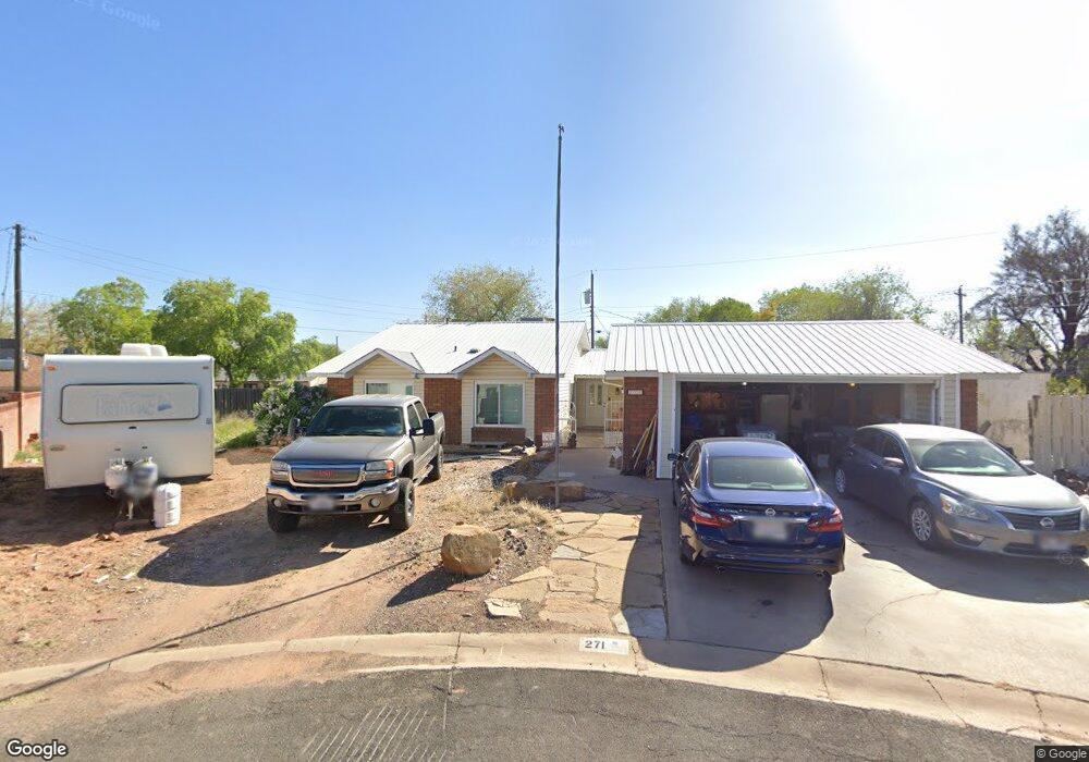
271 W 490 Cir N La Verkin, UT 84745
Estimated Value: $430,000 - $514,000
4
Beds
2
Baths
1,987
Sq Ft
$232/Sq Ft
Est. Value
About This Home
This home is located at 271 W 490 Cir N, La Verkin, UT 84745 and is currently estimated at $460,278, approximately $231 per square foot. 271 W 490 Cir N is a home located in Washington County with nearby schools including La Verkin Elementary School, Hurricane Middle School, and Hurricane High School.
Ownership History
Date
Name
Owned For
Owner Type
Purchase Details
Closed on
May 9, 2012
Sold by
Stratton Justin R
Bought by
Stratton Justin and Stratton Audra
Current Estimated Value
Home Financials for this Owner
Home Financials are based on the most recent Mortgage that was taken out on this home.
Original Mortgage
$121,827
Outstanding Balance
$84,566
Interest Rate
3.94%
Mortgage Type
New Conventional
Estimated Equity
$375,712
Purchase Details
Closed on
Apr 8, 2010
Sold by
Stratton Justin
Bought by
Stratton Justin and Stratton Audra
Home Financials for this Owner
Home Financials are based on the most recent Mortgage that was taken out on this home.
Original Mortgage
$119,340
Interest Rate
5.01%
Mortgage Type
New Conventional
Purchase Details
Closed on
Jun 29, 2009
Sold by
Corisis Deborah Eileen and Florie B Goodman Trust
Bought by
Corisis Deborah Eileen
Create a Home Valuation Report for This Property
The Home Valuation Report is an in-depth analysis detailing your home's value as well as a comparison with similar homes in the area
Home Values in the Area
Average Home Value in this Area
Purchase History
| Date | Buyer | Sale Price | Title Company |
|---|---|---|---|
| Stratton Justin | -- | Atlas Title Co | |
| Stratton Justin R | -- | Atlas Title Co | |
| Stratton Justin | -- | Accommodation | |
| Stratton Justin | -- | Southern Utah Title | |
| Corisis Deborah Eileen | -- | None Available |
Source: Public Records
Mortgage History
| Date | Status | Borrower | Loan Amount |
|---|---|---|---|
| Open | Stratton Justin R | $121,827 | |
| Closed | Stratton Justin | $119,340 |
Source: Public Records
Tax History Compared to Growth
Tax History
| Year | Tax Paid | Tax Assessment Tax Assessment Total Assessment is a certain percentage of the fair market value that is determined by local assessors to be the total taxable value of land and additions on the property. | Land | Improvement |
|---|---|---|---|---|
| 2025 | $2,016 | $264,715 | $60,500 | $204,215 |
| 2023 | $2,010 | $266,530 | $57,750 | $208,780 |
| 2022 | $2,095 | $261,525 | $49,500 | $212,025 |
| 2021 | $1,723 | $316,600 | $50,000 | $266,600 |
| 2020 | $1,635 | $280,900 | $50,000 | $230,900 |
| 2019 | $1,476 | $243,000 | $50,000 | $193,000 |
| 2018 | $1,478 | $119,845 | $0 | $0 |
| 2017 | $1,362 | $110,440 | $0 | $0 |
| 2016 | $1,197 | $93,170 | $0 | $0 |
| 2015 | $1,194 | $89,320 | $0 | $0 |
| 2014 | $1,151 | $84,920 | $0 | $0 |
Source: Public Records
Map
Nearby Homes