Estimated Value: $110,000 - $156,000
3
Beds
1
Bath
913
Sq Ft
$152/Sq Ft
Est. Value
About This Home
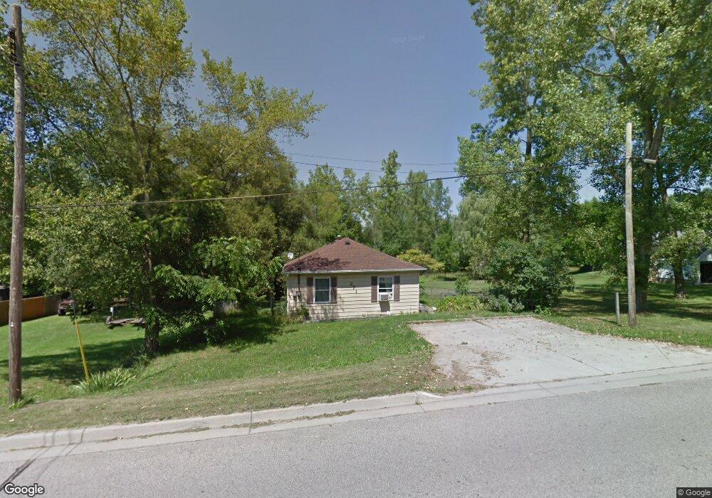
This home is located at 271 W State Rd, Grant, MI 49327 and is currently estimated at $139,228, approximately $152 per square foot. 271 W State Rd is a home located in Newaygo County with nearby schools including Grant Elementary School, Grant Primary Center, and Grant Middle School.
Ownership History
Date
Name
Owned For
Owner Type
Purchase Details
Closed on
Mar 7, 2022
Sold by
Belden Avenue Llc
Bought by
Bosch Zachary R
Current Estimated Value
Purchase Details
Closed on
May 3, 2019
Sold by
West Grant Llc
Bought by
Belden Avenue Llc
Purchase Details
Closed on
Apr 12, 2010
Sold by
Citifinancial
Bought by
West Grant Llc
Purchase Details
Closed on
Jan 3, 2003
Sold by
Higgins Livestock Inc
Bought by
Vanloon Michael Frank
Purchase Details
Closed on
Jul 3, 2002
Sold by
Dreyer John
Bought by
Higgins Livestock, Inc
Create a Home Valuation Report for This Property
The Home Valuation Report is an in-depth analysis detailing your home's value as well as a comparison with similar homes in the area
Purchase History
| Date | Buyer | Sale Price | Title Company |
|---|---|---|---|
| Bosch Zachary R | $126,000 | -- | |
| Belden Avenue Llc | $45,000 | -- | |
| West Grant Llc | $14,000 | -- | |
| Vanloon Michael Frank | $44,900 | -- | |
| Higgins Livestock, Inc | $32,000 | -- |
Source: Public Records
Tax History
| Year | Tax Paid | Tax Assessment Tax Assessment Total Assessment is a certain percentage of the fair market value that is determined by local assessors to be the total taxable value of land and additions on the property. | Land | Improvement |
|---|---|---|---|---|
| 2025 | $1,359 | $51,600 | $0 | $0 |
| 2024 | $13 | $45,500 | $0 | $0 |
| 2023 | $1,330 | $45,500 | $0 | $0 |
| 2022 | $1,445 | $37,500 | $0 | $0 |
| 2021 | $2,033 | $33,400 | $0 | $0 |
| 2020 | $1,992 | $32,900 | $0 | $0 |
| 2019 | $1,300 | $28,900 | $0 | $0 |
| 2018 | $1,286 | $24,500 | $0 | $0 |
| 2017 | $1,247 | $23,800 | $0 | $0 |
| 2016 | $1,237 | $22,500 | $0 | $0 |
| 2015 | -- | $20,200 | $0 | $0 |
| 2014 | -- | $21,100 | $0 | $0 |
Source: Public Records
Map
Nearby Homes
- 11298 S Gordon Ave
- 283 S Jones St
- 140 E Commerce St
- 151 & 153 Clark St
- Lot 19 S Elder Ave
- 2119 W 116th St
- 2308 W 112th St
- 0 W 112th St Unit 26006032
- 500 E 136th St
- 10041 S Mason Dr
- 10021 S Mason Dr
- 953 E 136th St
- 608 E The Ln
- 177 W 96th St
- 3193 W 112th St
- 12449 S Catalpa Ave
- 9425 S Benjamin Dr
- 9500 S Annie Ln
- 998 Thompson Rd
- 1773 N Newaygo Rd
- 309 W State Rd
- 350 State
- 253 W State Rd
- 268 W State Rd
- 240 W State Rd
- 350 W State Rd
- 0 W 120th St Unit 22008777
- 0 W 120th St Unit 72022008777
- 2110 W 120th St
- 2160 W 120th St
- 0 W 120th St Unit PAR C 3474205
- 1523 W 120th St
- 0 W 120th St Unit LOT B 3391043
- 0 W 120th St Unit APP 1 3370967
- 0 W 120th St Unit LOT A
- 234 W State Rd
- 230 W State Rd
- 219 W State Rd
- 29 Western Ave
- 33 Western Ave
Your Personal Tour Guide
Ask me questions while you tour the home.